
La Earthcache / The Earthcache
► Contexte géographique et géologique
Le marais de Goulaine est une vaste zone géographique humide au Sud Est de Nantes, traversé par la Goulaine et présentant une surface de plus de 2000 ha.
Ce marais présente une forme particulière avec un étranglement en son milieu (d'ou son nom, Gula-ana (goulet d’étranglement)) entre des barres granitiques, au niveau du pont de l'Ouen.
Cette particularité géologique est particulièrement visible sur la carte du BRGM :

Géologiquement parlant, la quasi-totalité du marais est constituée d'Alluvions modernes (notation Fz), présentant une origine fluvio-marine qui s'explique par l'histoire tectonique de la région marquée d'une succession de transgressions/régressions marines.
Mais pourquoi un marais à cet endroit, c'est à dire une zone constamment inondée ? Il existe ailleurs des zones dépressionnaires qui ne sont pas pour autant constamment submergées.
L'explication est à chercher dans l'étude pédologique du marais, c'est dire de son sol.
► Quelques définitions pédologiques
- Granulométrie : La classification de la fraction minérale se fait principalement sur le diamètre de ces éléments (granulométrie) :
• les graviers et cailloux (> 2 mm)
• les sables (20 µm-0,2 mm)
• les limons (2 µm-20 µm)
• l'argile granulométrique (< 2 µm)
- Texture : Le niveau de granularité et la proportion de chaque taille d’éléments minéraux détermine la texture du sol (sol sableux, limoneux ou argileux, ainsi que toutes les variantes intermédiaires).

► La perméabilité d'un sol
La perméabilité du sol est la propriété qu'a le sol de transmettre l'eau et l'air. Plus le sol est perméable, plus l'eau s'infiltre.
C'est en observant la texture du sol, sa structure, consistance et l’existence de pores visibles qu'il est possible d'évaluer cette perméabilité.
La taille et le nombre des pores du sol a beaucoup d'importance en ce qui concerne le taux d'infiltration (pénétration de l'eau dans le sol).
En général, plus la texture du sol est fine, plus la perméabilité est faible.

► Variations du niveau d'eau d'un marais
Il existe de nombreux facteurs pouvant expliquer cette variation :
- Le niveau d’imperméabilité de son sol.
- Les conditions climatiques générales (climat de la région, ici un climat océanique caractérisé par de régulières entrées maritimes).
- La saison (variations saisonnières hydrologiques du bassin versant (crues et inondations, ou à l’inverse, déficits estivaux parfois très marqués).
- Des facteurs anthropologiques (existence depuis la crue de 1910 de digues de régulation entre la Goulaine et la Loire.
Ces facteurs de variation ont un impact important sur la marais de Goulaine, qui peut varier d'une surface en eau de 2 000 ha inondée en période basse à plus de 3 200 ha à son niveau le plus haut.
Pour surveiller ces variations de niveau, il existe différents outils de mesure dont le plus simple est l'échelle limnimétrique.
Il s'agit d'une mire graduée placée verticalement ; la graduation est formée de deux bandes de carreaux de dix centimètres de côté ; cette mire est disponible en tronçons.

► Geographical and geological context
The marsh of Goulaine is a vast wet geographical area in the South East of Nantes, crossed by the Goulaine and having a surface of more than 2000 ha.
This marsh has a particular shape with a strangulation in its middle (hence its name, Gula-ana (bottleneck)) between granite bars, at the Ouen bridge.
Geologically speaking, almost all of the marsh is made up of modern alluvial deposits (Fz notation), with a fluvio-marine origin that can be explained by the tectonic history of the region marked by a succession of marine transgressions / regressions.
But why a marsh at this place, ie a constantly flooded area? There are other low-pressure areas that are not constantly submerged.
The explanation is to be found in the pedological study of the marsh, that is to say of its soil.
► Pedological definitions
- Particle size : the classification the mineral fraction is mainly on the diameter (particle size) : :
• gravel and pebbles (> 2 mm)
• sands (20 .mu.m-0.2 mm)
• silts (2 .mu.m-20 .mu.m)
• particle size clay (<2 microns)
- Texture : The level of granularity and the proportion of each size of mineral elements also determine the soil texture (sandy, loamy or clay soil, as well as all the intermediate variants).
► The permeability of a soil
Soil permeability is the property of the soil to transmit water and air. The more permeable the soil, the more water infiltrates.
It is by observing the texture of the soil, its structure, consistency and the existence of visible pores that it is possible to evaluate this permeability.
The size and number of soil pores is of great importance with regard to the rate of infiltration (penetration of water into the soil).
In general, the finer the soil texture, the lower the permeability.
► Variations in the water level of a marsh
There are many factors that can explain this variation:
- The level of impermeability of the soil.
- The general climatic conditions (climate of the region, here an oceanic climate characterized by regular maritime entries).
- Season (seasonal hydrological variations of the watershed (floods and floods, or conversely, summer deficits sometimes very marked).
- Anthropological factors (existence since the flood of 1910 of regulation dikes between the Goulaine and the Loire.
These variation factors have a significant impact on the Goulaine marsh, which can range from a flooded low water surface of 2,000 ha to more than 3,200 ha at its highest level.
To monitor these level variations, there are different measuring tools, the simplest of which is the scale limit.
It is a graduated staff placed vertically; the graduation is formed of two strips of tile ten centimeters in length; this pattern is available in sections.
► Sources bibliographiques / Bibliographical sources
Les Questions / The Questions
La lecture attentive du descriptif de la cache, ainsi qu'une observation des éléments de terrain et un peu de déduction sont normalement suffisants pour répondre aux questions de cette EarthCache.
A careful reading of the description of the cache, as well as observation of terrain features and some deduction is usually sufficient to answer questions of this EarthCache.
Questions pour valider :"Pédologie au Marais de Goulaine"
Questions to validate: "Pedology in the Goulaine Marsh"
L'existence d'un marais « mouillé » (en permanence inondé) est le signe d'une vaste couche superficielle à très faible perméabilité.
Est-ce le cas pour le marais de Goulaine ? Pour déterminer cela, étudions son sol.
Pour cette étude, vous voici au port du Montru, au bord d'un des chenaux qui sillonnent le marais.
The existence of a "wet" marsh (permanently flooded) is a sign of a large surface layer with very low permeability.
Is this the case for the Goulaine marsh? To determine this, let's study his soil.
For this study, here you are at the port of Montru, at the edge of one of the channels that crisscross the marsh.
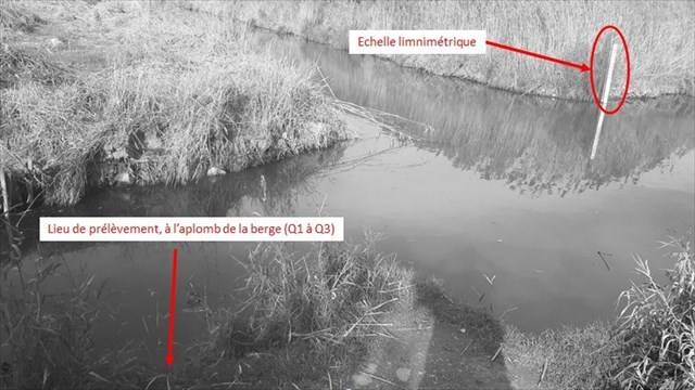
- Question 1 : Observer le sol sur la partie nue au niveau de la partie plongeante de la berge en vous accroupissant au bord de celle-ci.
Voyez-vous des pores au niveau du sol ?
- Question 1 : Observe the ground on the bare part of the diving part of the bank.
Do you see pores at ground level?
- Question 2 : Prenez un peu de sol. Faites le rouler entre vos doigts. Dans quelle classe granulométrique pouvez-vous le ranger ? Caractériser sa texture.
- Question 2 : Take a little soil. Roll it between your fingers. In what size class can you put it away? Characterize its texture.
- Question 3 : En fonction des questions précédentes, caractériser la perméabilité de ce sol. Est-elle cohérente avec la présence du marais de Goulaine ?
- Question 3 : Based on the previous questions, characterize the permeability of this soil. Is it consistent with the presence of the Goulaine marsh?
- Question 4 : Observer l'échelle limnimétrique et noter la hauteur de l'eau du marais à votre passage.
Sachant que la hauteur d'eau était de 1.75 mètres au niveau du port au 01 novembre après un été et un début d'automne en très fort déficit hydrique, donner des hypothèses permettant d'expliquer la différence de niveau entre votre observation et ce niveau de référence.
- Question 4 : Observe the gauge and note the height of the marsh water as you pass.
Knowing that the water level was 1.75 meters at the port level on November 01 after a summer and early autumn with very high water deficit, give hypotheses to explain the difference in level between your observation and this level reference.
Vous pouvez vous loguer sans attendre notre confirmation,
mais vous devez nous envoyer les réponses en même temps soit par mail via notre profil (
fafahakkai), soit via la messagerie geocaching.com (Message Center).
S'il y a des problèmes avec vos réponses nous vous en ferons part.
Les logs enregistrés sans réponses seront supprimés.Une photo de vous ou de votre GPS en Noir et Blanc avec le port du Montru en arrière plan serait la bienvenue, mais n'est pas obligatoire.
You can log this cache without waiting for our confirmation, but you must send us the answers at the same time, by e-mail via our profile (fafahakkai) or by the system of Message Center of geocaching.com.
If there is a problem with your answers we will notify you. The logs recorded without answers will be deleted.
A photo of you or your GPS in Black and White with the port of Montru in the background would be welcomea but is not mandatory.
Rappel concernant les « Earthcaches »: Il n'y a pas de conteneur à rechercher ni de logbook à renseigner. Il suffit de se rendre sur les lieux, de répondre aux questions ci-dessus et de nous renvoyer les réponses.
Reminder concerning "Earthcaches": there is neither a container to look for nor a logbook to sign. One need only go to the location, answer to the differents questions and send us the answers.