Note: A measuring tape is highly recommended for this EarthCache. There are six tasks required for this Earchcache including a photo task.
Lord Meath’s Lodge
This small ruin known as Lord Meath’s Lodge was built in the 19th century and marked the cliff walk boundary between Lord Meath’s estate and that belonging to the Dublin & South Eastern Railway. The lodge operated as a toll station charging a penny per person but not on Fridays, as on this day the cliff walk was closed for the private use of the Brabazon family (Lord Meath of Kilruddery House).
The ruin is of a two-story dormer house that originally had an arched brick doorway, the steps nearby led up into Lord Meath’s estate. The granite probably came from the nearby Dalkey quarry which is only 11 kms away, it is disused now but Granite was quarried there during the 19th century. Other stone was locally sourced. Red bricks used in its construction came from England. The remains of a brick fireplace are also visible.
Building with granite
Granite is one of the most commonly used and widely occurring stones in the world. It is known for its properties of durability and permanency of its colour and texture. Granite has been used as a building material since ancient times and will far outlast the building in which it's installed.
It is an igneous rock (formed from volcanic activity), And is one of the hardest stones available, having a rating of 7 on the Moh's Measurement of Hardness Scale. In contrast, marble is rated only a 3.
Formation Of Granite
Granite is believed to have been formed as long ago as 300 million years. It began as a mass of molten rock, estimated at 1300 -1400 degrees F., formed by volcanic activity about 11-12 miles underground. Forces of nature caused the magma to gradually rise to the surface where it began to cool very slowly over the next million years or so, solidifying into granite. Over time, the land above it eroded, leaving a scattering of granite quarries all over the world, in this map you can see where the granite in Ireland is.
Granite is composed primarily of feldspar, quartz, and mica. It may also contain hints of muscovite, biotite, hornblende, and pyroxene and other minerals. These minerals are what give it its various colours. The white mineral grains in granite are feldspar, our planet's most abundant rock, which makes up about 60% of the earth's surface. The light grey, glass-like veins are quartz, and the black, flake-like veins are biotite or black mica. Other minerals imbue the stone with a rainbow of colours, depending on their source, and these varieties are often given unique names.
Bedrock map of Ireland

Cache Logging Requirements
To log this Earth Geocache, please send me the answers to the following questions, in the correct order via the message centre preferably.
- Which parts of the ruined building is granite?
- Why was it used for these parts of the building?
- Which minerals listed above, that give the granite it’s colours, can you see in this granite?
- Describe the texture of the half cylinder shaped piece of granite.
- Locate the half cylinder shaped piece of granite (opposite old gate post) and estimate the weight of it in Kilograms.
- As per the updated guidelines, a Photo can now be used at part of the logging task. You have two options in regards to the photo:
(a) Take a photo of yourself with Lord Meath's Lodge in the background at GZ.
(b) If you prefer not to take a photo of yourself please take a photo of a personal item with Lord Meath's Lodge in the background at GZ.
Attach the photo to your log, do not send it to me. Please ensure that the photo is taken in close vicinity of Lord Meath's Lodge. Photos taken at other locations along the Cliff Walk including at GC43 will not be accepted.

The weight can be estimated by finding the volume of the rock and multiplying the volume by the rocks Specific Gravity. To Determine The Rocks Volume and subsequence weight, use the formula above or follow the simple steps below and insert your measurements. Measurements should be taken in centimetres.
Step 1 – Find The Radius
To find the radius, measure the diameter of the rock and divide it by 2.
Step 2 – Find The Length
Measure the length of the rock.
Step 3 – Calculate The Volume
Calculate the volume using the measurements taken above and substitute them into the formula below:
0.5 x 3.141 x (radius) x (radius) x (length) = Volume in cubic cm
Note: 0.5 is included in the formula above as this is a half cylinder.
Step 4 – Calculate The Weight
Using the chart below, find the Specific Gravity of Granite. Insert the figures for Volume and Specific into the formula below.
(Volume) x (Specific Gravity) = Weight in grams.
Now convert the weight to Kilograms.
Please Note:
- In regards to Group logs, one message containing the required information is permitted, however the geocaching names of the group members must be stated in the message and each log. Not providing the names of group members may result in logs being mistakenly deleted.
- Each Found log must contain the required photo, see the requirement above for further information.
- Logs without the required information and photo provided will be deleted without notification. If you plan to send the required information at later time, please post a "Write Note" rather than a "Found it" log.
- Don't post photos of the half cylinder shaped piece of granite. Any logs with the piece of granite displayed will be deleted.
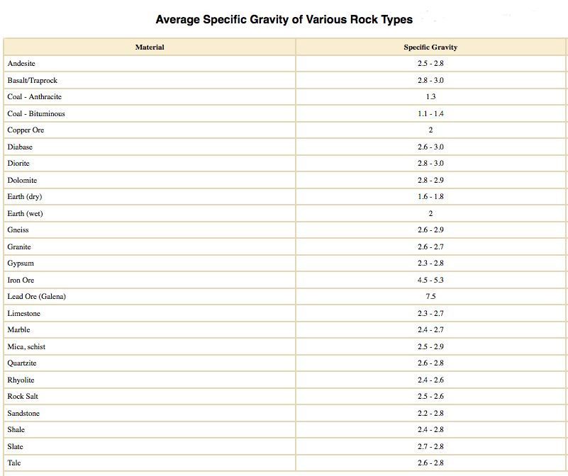 Average Specific Gravity Of Specific Rock Types g/cm3
Cliff Walk Series
The Greystones to Bray Cliff Walk is a beautiful scenic walk that meanders along the east coast of Wicklow between Greystones & Bray. The walk is approxmatly 6K in legnth and is level most of the way. End to end the walk should take approximatly two hours to complete. The walk can be either started at Greystones Harbour, or from Bray at the southern end of the promanade. At the end of the walk you can get the train back to your starting point.
As well as the beautiful scenary the Cliff Walk is home to different types of seabirds and various types of colourful wildflowers. Dolphins, black harbour porpoises and basking sharks are known to swim in the waters around the cliff off of Bray Head.
Here is a complete list of the caches in this series:
There are also a number of caches along the walk that are not part of the series:
|