LA CONFLUENCE GARONNE-ARIEGE :
Située dans la plaine d’inondation de l’Ariège et de la Garonne, la RNR (Reserve Naturelle Régionale) Confluence Garonne-Ariège constitue un lieu patrimonial d’exception en termes écologique et biologique, d’intérêt régional, voire national dans un contexte périurbain prononcé.

Une multitude d’espèces animales et végétales trouve des conditions de vie favorables dans cette mosaïque d’habitats naturels de relativement bonne qualité (corridor fluvial, milieux ouverts ou semi-ouverts, milieux humides, formations boisées, terres agricoles et paysages artificiels). Cette succession de milieux naturels résulte de l’action physique de l’eau et de l’apport de semences par les crues. Inondations, érosions, dépôts, sont à l’origine d’une dynamique créant régulièrement des milieux pionniers, ralentissant une évolution inéluctable vers la forêt.
Sont ainsi protégées les zones humides et boisées des bords de rivière (les ripisylves), lesquelles sont des zones naturelles d'épanchement des cours d'eau en cas de crue.
Le fort courant au niveau de la confluence crée parfois des irrégularités au niveau du lit, et est à l’origine de la création géologique de « marmites » ou « oules » :
FORMATION DES MARMITES (OULES) :
Une marmite (parfois appelée chaudron, marmite du diable ou marmite de géant) est une cavité naturelle percée dans la roche par des cours d'eau, généralement torrentueux, drainant des galets ou du gravier.
Dans le midi de la France, on utilise plutôt le terme d'origine occitane « oule », ou parfois, improprement, « gour ».
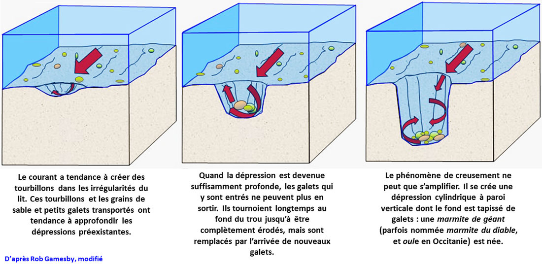
Les marmites se forment généralement dans des boucliers composés de roches anciennes ayant des résistances variées à l'érosion. Des cours d'eau entraînent les galets les plus durs dans des tourbillons, ce qui élargit et creuse les cavités. Ces galets doivent être au moins aussi durs que le fond du torrent. Le mouvement de rotation creuse, à partir d'une irrégularité de relief initiale, une érosion progressive de la roche en forme de marmite.
Dans certaines marmites, les galets peuvent rester longtemps et prendre des formes ovoïdes, avec une section circulaire, et parfois former des sphères presque parfaites. Ces galets sont expulsés lors de crues exceptionnelles et se retrouvent en aval dans le lit de la rivière, facilement reconnaissables parmi les autres galets grâce à leurs formes régulières et à leur poli.
Lorsque le cours d'eau est très incliné, ces marmites peuvent s'étager le long d'une cascade, formant des bassins parfois esthétiques, débordant l'un dans l'autre. Avec la progression de l'érosion, certaines marmites peuvent finalement se percer et se vider partiellement ou totalement selon la taille de l'ouverture et le débit de l'eau.
POUR VALIDER LA CACHE
Rendez-vous aux coordonnées indiquées, et répondez SVP aux questions suivantes en vous aidant du texte plus haut :
- Pourquoi la confluence Garonne-Ariège est-elle propice à la création de marmites ?
- Quelle forme géométrique est créée par le creusement des galets dans une marmite ?
- Apercevez-vous des marmites depuis les coordonnées indiquées ?, expliquez pourquoi. ?
- Devant vous, de quelle matière est constitué le lit de marne au fond de la rivière (aidez vous du panneau pas loin...)?
5) OPTION: si vous le pouvez, prenez-vous (ou votre GPS) en photo près des coordonnées
THE CONFLUENCE GARONNE-ARIEGE :
The CONFLUENCE GARONNE-ARIÈGE is located in the plain of flood of the Ariège and the Garonne rivers; the Confluence Garonne-Ariège RNR (Regional Natural Reserve) constitutes a patrimonial place of exception in ecological and biological terms, regional, even national interest in a pronounced outer-urban context.
A multitude of animal and plant species finds favorable living conditions in this mosaic of natural housing environments of relatively good quality (river corridor, open or semi-open circles, wet circles, woody trainings, farmlands and artificial landscapes). This succession of natural circles results from the physical action of the water and from the contribution of seeds by the floods. Floods, erosions, deposits are at the origin of a dynamics creating regularly circles pioneers, slowing down an inevitable evolution towards the forest
The wet and woody zones of river banks are so protected. They are natural zones of effusion of streams in case of floods.
The important flood at the level of the confluence sometimes creates irregularities at the level of the bed, and is at the origin of the geologic creation of "pots" (”marmites” or "oules" in French language):
MECHANISM OF THE CREATION OF POTS (MARMITES) :
a pot (sometimes called cauldron, devil’s pot or giant's pot) is a natural cavity drilled in the rock by streams, generally torrential, draining pebbles or gravel.
In the South of France, we use rather the term of Occitan origin "oule", or sometimes, improperly, "gour".
Pots form generally in shields consisted of old rocks having resistances varied in the erosion. Streams pull the hardest pebbles in whirlwinds, what widens and digs cavities. These pebbles must be so hard at least as the bottom of the torrent. The movement of rotation digs, from an initial irregularity of relief, a progressive erosion of the rock in the shape of pot.
In some pots, pebbles can stay for a long time and take egg-shaped forms, with a circular section, and sometimes form almost perfected spheres. These pebbles are expelled during exceptional floods and find themselves downstream in the bed of the river, easily recognizable among the other pebbles thanks to their regular forms and to their polished.
When the stream is very oblique, these pots can stage along a waterfall, forming sometimes esthetic ponds, overflowing all in all. With the progress of the erosion, certain pots can finally drill and empty partially or totally according to the size of the opening and the flow of the water.
TO VALIDATE THE CACHE
Please go to the given coordinates and answer to the following questions by helping you of the higher text.
1) Why the Garonne-Ariège conflurnce is convenient to the creation of pots ?
2) What geometrical form is created by the digging of pebbles in a pot ?
3) Can you observe natural pots from the given coordinates ? Please explain why.
4) Of what material is established the bed of marl at the bottom of this river ?
5) OPTION: If possible, please take a photo of yourself (or your GPS) near the coordinates