Les Passes et le Banc d'Arguin
D'une largeur moyenne de 3 kilomètres, le couloir d'entrée du Bassin d'Arcachon est délimité par la Dune du Pilat au sud et par la Pointe du Cap Ferret au nord. Entre ces deux points, de vastes bancs de sable, dont le célèbre Banc d'Arguin, dessinent des passes étroites constituant les seules voies d'accès navigables entre le Bassin d'Arcachon et l'Océan Atlantique.
 With an average width of 3 kilometers, the entrance corridor of the Bassin d'Arcachon is bounded by the Dune du Pilat to the south and the Pointe du Cap Ferret to the north. Between these two points, vast sandbanks, including the famous Banc d'Arguin, draw narrow passes constituting the only navigable access routes between the Bassin d'Arcachon and the Atlantic Ocean

Les Passes du Bassin d'Arcachon
Elles sont les chenaux de vidange du Bassin d'Arcachon, qui permettent aux navires venant de l'océan Atlantique de pénétrer dans le Bassin.
Quatre fois par jour, entre 200 et 400 millions de m3 d'eau rentrent et sortent du bassin d'Arcachon sous l'action de la marée, à une vitesse moyenne de 2 mètres par secondes. . L'entrée du bassin d'Arcachon est large de plusieurs kilomètres mais elle est encombrée par des bancs de sable prolongeant la pointe du Cap Ferret ainsi que par un grand banc émergeant en permanence au milieu : le Banc d'Arguin. Les passes elles-mêmes sont donc relativement étroites et surtout très mouvantes ; historiquement deux passes s'ouvrent alternativement selon un cycle qui dure de 70 à 80 ans : l'une au sud longe la côte et la Dune du Pilat, l'autre passe au nord du banc d'Arguin.
The Bassin d'Arcachon passes are the drainage channels of the Bassin d'Arcachon, which allow ships coming from the Atlantic Ocean to enter the Basin.
Four times a day, between 200 and 400 million m3 of water flows in and out of the Arcachon basin under the action of the tide, at an average speed of 2 meters per second. . The entrance to the Arcachon basin is several kilometers wide but it is encumbered by sandbanks extending the point of Cap Ferret and by a large bench permanently emerging in the middle: the bench of Arguin. The passes themselves are therefore relatively narrow and above all very moving; historically two passes open alternately in a cycle that lasts from 70 to 80 years: one south along the coast and the dune of the Pilat, the other passes north of the bank of Arguin.

Une physionomie changeante
L'aspect des Passes et des bancs de sable qui les jalonnent varie tellement que les marins hésitent à se fier aux bouées...
Ce caractère mouvant résulte de deux phénomènes naturels:
- En premier lieu, il est la conséquence d'un important courant marin orienté nord-sud qui longe la côte Atlantique depuis l'Estuaire de la Gironde jusqu'au Bassin d'Arcachon. Ce courant charrie en effet chaque année près de 600 000 m3 de sable. Or ce sable a tendance à s'agglutiner sur les bancs qui jalonnent l'entrée du Bassin, modifiant du même coup la morphologie des passes.
- Le second phénomène tient au jeu des marées, dont la puissance tend au contraire à éroder et à fragiliser les bancs de sable. Le sable soulevé par les marées est ainsi "repris" par le courant côtier, et se déplace de nouveau vers le sud avant finalement de s'accumuler vers la Dune du Pilat.
De l'action conjointe de ces phénomènes résulte l'existence des bancs de sables présents dans les passes, dont...Le Banc d'Arguin
A changing physiognomy
The appearance of the Passes and the sandbanks that dotted them varied so much that the sailors hesitated to trust the buoys ...
This shifting character results from two natural phenomena:
- Firstly, it is the result of an important north-south oriented marine current that runs along the Atlantic coast from the Gironde estuary to the Bassin d'Arcachon. This current carries in fact every year nearly 600 000 m3 of sand. This sand tends to agglutinate on the benches which mark the entrance to the basin, thus modifying the morphology of the passes.
- The second phenomenon is due to the tides, whose power tends to erode and weaken the sand banks. The sand raised by the tides is thus "taken up" by the coastal current, and moves again towards the south before finally accumulating towards the Dune of the Pilat.
From the joint action of "these phenomena results the existence of the sandbanks present in the passes, of which ... Le Banc d'Arguin
Le Banc d'Arguin
Plus grand banc de sable de la côte Aquitaine. Sa forme change et évolue constamment selon les vents, tempêtes et marées, ses dimensions à marée basse sont approximativement 5 kilomètres de long sur 1 kilomètres de large.
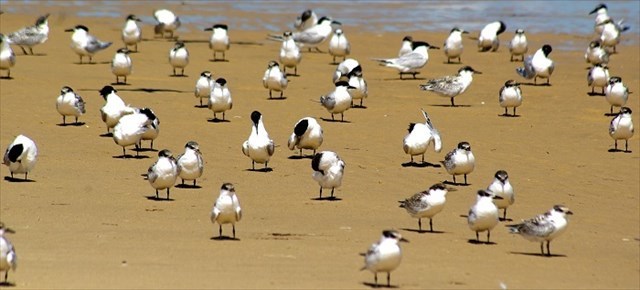
Il est aussi une zone de repos protégée pour un grand nombre d’espèces d’oiseaux migrateurs. Il abrite ainsi chaque année au printemps la plus importante colonie de sternes Caugeks d’Europe (hirondelles de mer). Le Banc d’Arguin est d’ailleurs classé réserve naturelle depuis 1972. Le banc est une réserve naturelle essentiellement ornithologique.
Les 3 zones du banc d'Arguin :
– Une zone sub-littorale d’une profondeur de 20 mètres qui est la partie immergée en permanence. Ses fonds sont couverts de grandes zostères (sorte d’algue d’un centimètre de large et d’une trentaine de long) qui créent un vaste herbier marin
– Une partie délimitant les plages et les étendues de sable visibles ou non en fonction des marées. Cette zone du banc d’Arguin est souvent modifiée par la nature (vent/marées)
– Le sommet des bancs de sable, peuplé par une végétation typique des dunes du littoral atlantique. On y retrouve essentiellement des oyats qui fixent les petites dune de sable pour qu’elles aient moins de prises au vent.
D'autres bancs de sable ponctuent l'entrée du Bassin, plus ou moins visibles selon les marées: Banc du Toulinguet, Banc du Chien.
Le Banc d'Arguin
The Banc d'Arguin is located at the gateway to the Bassin d'Arcachon, at the foot of the Dune du Pilat and facing the Pointe du Cap Ferret, the Banc d'Arguin is the largest sandbank on the Aquitaine coast. Its shape changes and evolves constantly according to the winds, storms and tides, its dimensions at low tide are approximately 5 kilometers long and 1 kilometers wide.
It is also a protected rest area for a large number of migratory bird species. It hosts each year in spring the largest colony of European Caught Terns (Sea Swallows). The Banc d'Arguin is also listed as a nature reserve since 1972. The bench is a nature reserve is essentially ornithological.
The 3 zones of the bank of Arguin:
- A sub-littoral zone with a depth of 20 meters which is the part immersed permanently. Its bottoms are covered with large eelgrass (a kind of seaweed one centimeter wide and thirty long) which create a vast marine herbarium
- A part delimiting the beaches and the stretches of sand visible or not according to the tides. This area of the bench of arguin is often modified by nature (wind / tides)
- The top of the sandbanks, populated by vegetation typical of the dunes of the Atlantic coast. There are basically oyats which fix the small sand dunes so that they have less catches to the wind.
Other sandbanks punctuate the entrance to the Bassin, more or less visible according to the tides: Banc du Toulinguet, Banc du Chien.
Validation de la cache
Le meilleur point de vue sur les Passes et le Banc d'Arguin est incontestablement la Dune du Pilat.
Rendez vous à l'étape 2, ce qui vous permettra de répondre à la dernière question.
Pour valider cette cache, vous devrez répondre aux questions suivantes :
1 - Combien de m3 d'eau transitent par les Passes à chaque marée ?
2 - Quel qualificatif caractérise principalement les Passes ?
3 - Comment expliquer la présence de ces bancs de sables ici, et leur constante évolution?
4 - Combien de bancs de sable distincts comptez vous depuis ce point d'observation ?
Loguez cette cache 'Found it" et envoyez moi vos propositions de réponses soit via mon profil, soit via la messagerie geocaching.com (message center) et je vous contacterai en cas de problème.
Validation conditions
The best point of view on the Passes and the Bench of Arguin is undoubtedly the Dune of the Pilat.
Go to step 2, which will allow you to answer the last question.
To validate this cache, you will need to answer the following questions:
1 - How many m3 of water pass through the Passes at each tide?
2 - What is the main characteristic of the Passes?
3 - How can we explain the presence of these sand banks here, and their constant evolution?
4 - How many separate sandbanks do you have from this observation point?
Log in this 'Found it' cache and send me your suggestions for answers either via my profile or via the geocaching.com message center and I will contact you if there is a problem.