This EarthCache will take you to Brent Tor, which is famous for its small 13th Century church perched on top of the tor. The tor, and the church, can be seen on the sky line from much of the western side of Dartmoor. Apart from its location there are a couple of items of note within the graveyard. The first is the sundial, which is fixed to the southern side of the church. Based on the date, 1694 carved into it, it is thought to be the oldest sundial in Devon. The second is also on the southern side of the church and is the grave of Ingaret Stella Van Der Post, who is claimed to be a direct descendant of Robert Giffard, the churches founder. As well as this historic church there is some important archaeology on the tor. As you arrive it quickly become apparent that there are a lot of definite earthworks. These are thought to be a mixture of an Iron Age hillfort, and a possible site of a medieval fair.
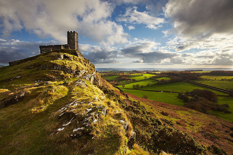
As well as this being one of the more accessible and photogenic of the Dartmoor tors it is also unusual geologically. Dartmoor is famous for its beautiful, and often inhospitable, granite landscape dominated by tors. These tors were created because the granite geology is very resistant to weathering. Brent Tor is one of the few tors on Dartmoor that is not made of granite. Brent Tor is made from basaltic lava that flowed into a shallow sea some 350 million years ago. As the lava flowed out into the sea some solidified, whilst others broke up thanks to the explosive cooling. The lava that solidified formed pillow lavas that are called this because of the pillow shaped structures due to their cooling by the sea water. This material formed a mound on the sea floor that was then eroded and moved by the sea currents down the slope. Over time this was covered by later sediments. After the land became above sea level these softer sediments were eroded, leaving the harder lava was left behind leaving the tor standing high above the surrounding land.
As mentioned this site demonstrates the reworking effect of underwater currents as down the slopes. There is a 'volcaniclastic apron', which means a surrounding spread of loose volcanic debris. The resulting tor is mainly composed of coarsely bedded volcaniclastic material that have a southerly dip. On the southern slopes, below the 13th century chapel, there are hyaloclastites. When underwater vents and volcanoes let lava into the sea, as is the case at Brent Tor, the quenching and fragmentation cause the formation of angular glassy fragments called hyaloclastite. The rest of the tor is made up of a mixture of these graded hyaloclastites and pillow breccias. Pillow breccias are breccias, which is a conglomerate consisting of angular inclusions, that display the 'pillow' structures present in pillow lavas.
Breccias can be both sedimentary and volcanic in their formation, and in the case of the material forming Brent Tor it is the latter. During the flowing of the magma/lava into the sea from the volcanic vent, fragments of already/previously formed rocks can get carried along by the flow. This can result in the fragments shattering due to the intense heat. After the flow comes into contact with the water, and therefore cooling down, these rock fragments become inclusions within the newly formed breccia.
To log this EarthCache go to the posted coordinates and the church waypoint and send me a message or email answering these following questions
Posted coordinates
1) Look at the rock face and describe the appearance and feel of the rock face. (E.G. is it 'bubbly' or smooth)
2) Are there any inclusions within the rock face, and if so describe them and if they differ from the surrounding volcanic rock.
Head towards the church waypoint
3) Look at the 36 steps before the gate. Are they made from the same geology as the tor?
4) Look at the material used to construct the church. Based on what you can see do you think it is made from the same geology as the tor?
5) Go inside the porch of the church and look at the small plaque on the wall. What does it say?
Bonus question (not required). If you are able to what is the geology of the 36 steps?