 SK: SK:
Touto keškou Vás chcem priviesť k jednému z najvyšších miest Slovenska (2.634 m.n.m.) a zároveň jedným z najkrajších výhľadov.
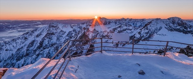
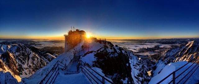
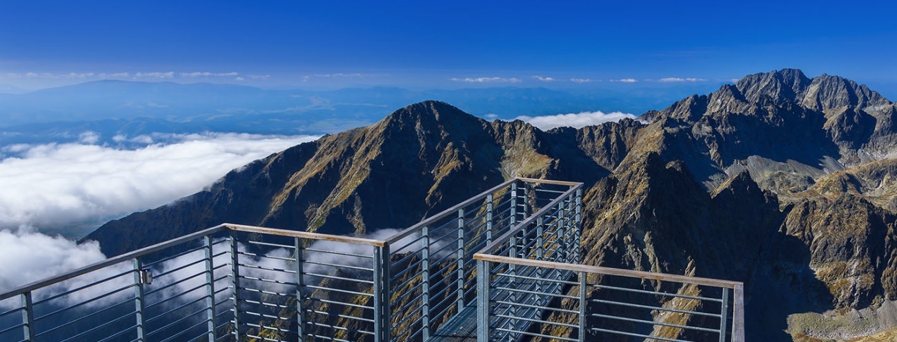
Lomnický štít tvorí strechu Slovenska. Z jeho vrcholu je vidno krásy Tatier. Pri troche šťastia máte nebo pod nohami a Vy si pripadáte ako anjel (bez krídiel). Z oblakov vyčnievajú len vrcholky slovenských dominant. Táto dominanta Tatier je najnavštevovanejším z dvojtisícoviek, lebo na jej vrchol sa od 19. decembra 1941 dostanú lanovkou bez námahy aj neturisti. (Prevádzková doba lanovky a cenník)
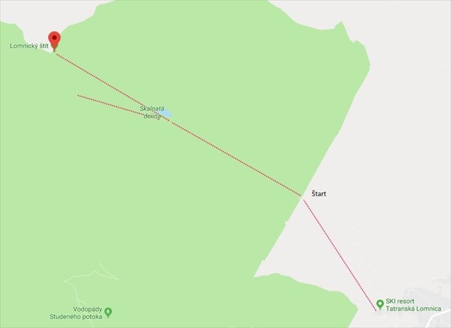
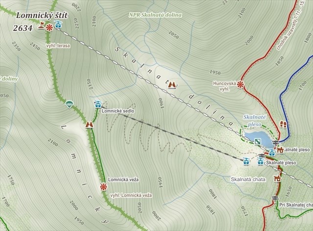
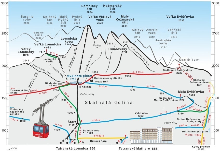
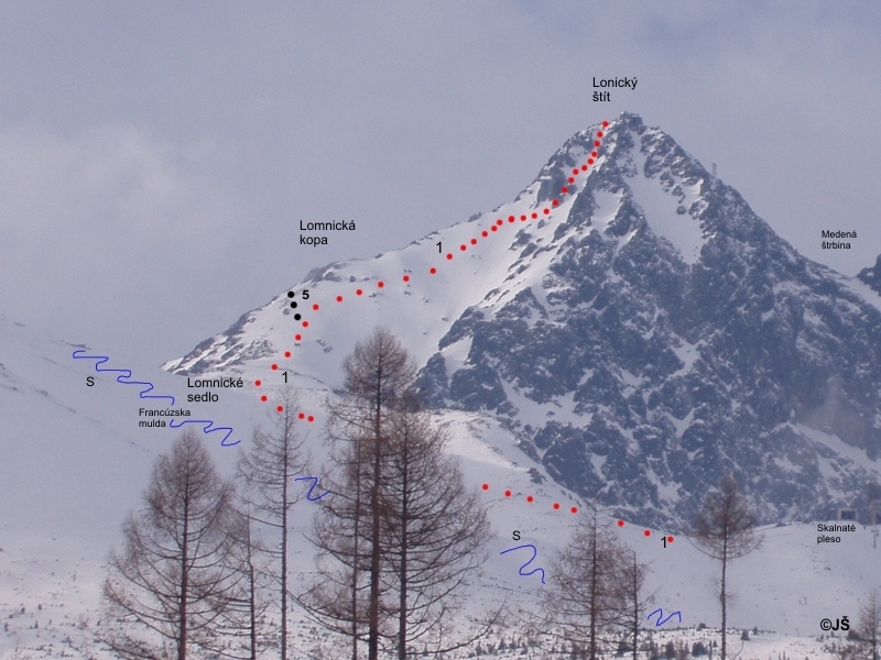
Na vrchol sa dostanete buď lanovkou zo Skalnatého plesa, ktorá bola považovaná v čase výstavby za najmodernejšiu v Europe, alebo po neznačenom turistickom chodníku z Lomnického sedla, ale len v sprievode s horským vodcom. Kto si chce šetriť nohy, využije lanovku do sedla.
Tatranská Lomnica 910 m n.m. -> Skalnaté pleso (1 750 m n.m.)-> Lomnické sedlo 2 190 m n.m.
Najvyššie položená stavba:
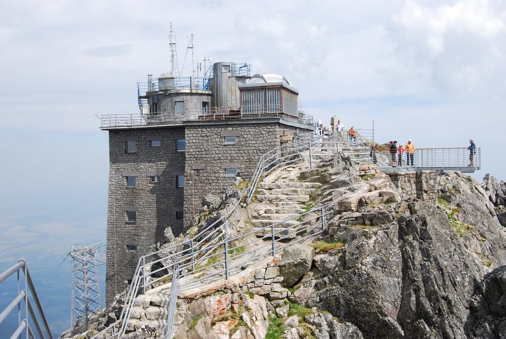
Od r.1957 je na vrchole Observatórium Lomnický štít , ktoré je najvyššie položenou stavbou na Slovensku. Nachádzajú sa tu astronomické a meteorologické pracoviská SHMÚ a aj televízna retranslačná stanica.
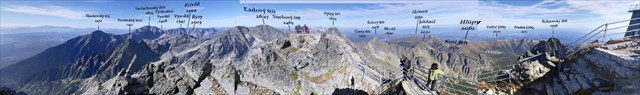
Tri hrebene:
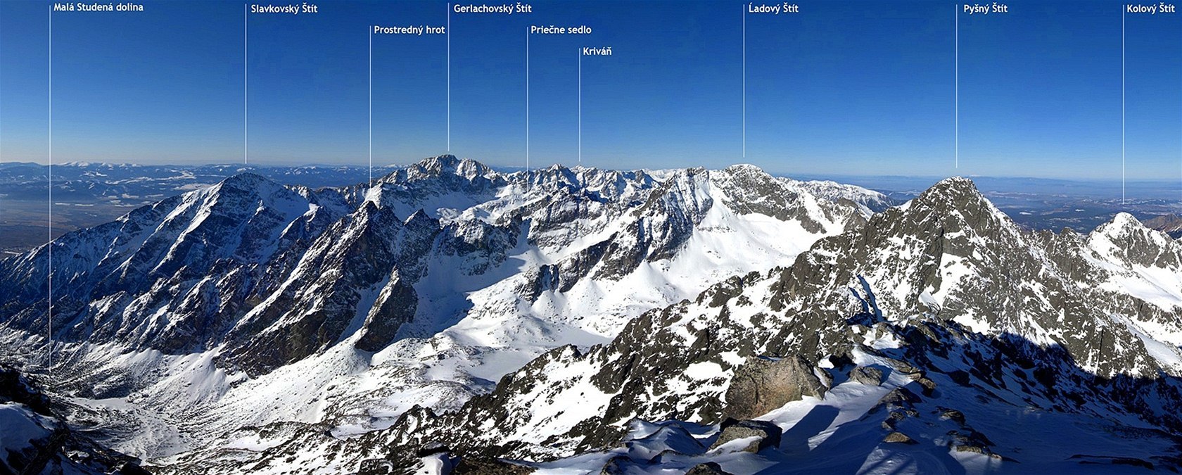
Z vrcholu, pripomínajúceho trojhrannú pyramídu, vedú tri hrebene:
• severozápadný k Pyšnému štítu, Malému Pyšnému štítu, Spišskému štítu po Baranie sedlo a ďalej cez Baranie rohy pokračuje hlavným hrebeňom Tatier na západ
• severovýchodný, vedúci cez Vidlový hrebeň (Západná, Veľká a Východná Vidlová Veža) a Kežmarský štít ku Huncovskému štítu alebo cez Malý Kežmarský štít k Veľkej Svišťovke
Vďaka svojej vysokej polohe, expozícii, turistickej náročnosti a úžasným výhľadom patrí k tomu najkrajšiemu, čo v Tatrách máme. Pozrite si video
• južný, Lomnický hrebeň, vedúci cez Lomnickú kopu, Lomnické sedlo, Veľký Lomnický hrb, ponad Zamkovského chatu po Lomnickú vyhliadku
Ako to je s prvenstvom:
V minulosti bol považovaný za najvyšší štít Vysokých Tatier. Až neskôr keď sa presadila téza, že „všetko čo má svoje pomenovanie, je považované za vrchol“, zaradilo Lomnický štít na 2.miesto hneď za Gerlachovskú vežu (2.655 m.n.m.).
Ako vzniklo jeho meno:
Lomnický štít si počas histórie prešiel rôznym pomenovaním.
V 18.storočí ho označovali ako „Kežmarský štít“
Za otca súčasného pomenovania môžeme považovať Juraja Buchholtza st., ktorý náízov Lomnický štít použil v diele „Das weit und breit erschollene Zipser Schnee-Gebürg“ z roku 1719. Nový názov sa však ujímal veľmi pomaly.
Ešte v 19.storočí poľský geolog píše o ňom ako Krapak – pravdepodobne transkripcia Karpát.
Názov Lomnický štít sa ustálil v prvej polovici 19. storočia, keď sa štítom dávali mená podľa dedín, v ktorých chotároch sa nachádzali (r.1947).
V dávnom ľudovom názvosloví sa stretnete aj s menom Dedo.
Podnebie:
Pred výstupom na vrchol (aj lanovkou) odporúčam vziať teplé oblečenie. Aj v lete je dobré vziať si niečo proti vetru. Vo výškach sa počasie rýchlo mení a vrchol Lomnického štítu má drsné, studené podnebie. Charakteristické sú vysoké atmosférické zrážky v zimných mesiacoch.
V rokoch 2000 – 2012 bola:
• priemerná teplota: −3 °C
• maximálna teplota: +18,3 °C (30/07/2005)
• minimálna teplota: −29,2 °C (28/02/2005)
• zrážky: 1 900 mm
• maximálna snehová pokrývka: 410 cm (25/03/2009)
• najchladnejší mesiac: február
• najteplejší mesiac: júl, august
• najsuchší mesiac: september, október
PODMIENKA PRE ZALOGOVANIE:
POVINNÉ:
Do logu priložiť fotku seba S RUKAMI NAD HLAVOU DO TVARU STRECHY, pri tabule LOMNICKÝ ŠTÍT 2634m. ( podľa vzorovej fotky). Kto sa nerád ukazuje na fotkách, môže si premalovať tvár . Za pekného počasia urobte širší záber, kde je vidno pohorie a krásne výhľady. Pri hmle, foto z blízka pri zábradlí s nápisom. Bez tohoto budú logy ZMAZANÉ !
DOBROVOĽNÉ:
Poteší viac fotiek z okolia a uvedenie 3 vonkajších teplôt namerané v Tatranskej Lomnici, Na Skalnatom plese a na vrchole Lomnického štítu. (postačia odhadované / pocitové).
Virtuálna odmena - 2017/2018
Táto virtuálna cache vznikla ako súčasť limitovanej edície vytvorených medzi 24. augustom 2017 až 24. augustom 2018. Príležitosť založiť virtuálnu cache dostalo iba 4 000 kešerov . Viac informácií o virtuálnych odmenách sa dočítate v blogu Geocachingu.

Ďakujem za Vašu návštevu a pekné fotky, ktoré priložíte.
|
 EN: PEAK of LOMNICKÝ EN: PEAK of LOMNICKÝ
With this cache i would like to bring you to one of the highest places in Slovakia (2.634 m) and also with one of the most beautiful views.
Peak of Lomnický creates the roof of Slovakia. From his peak u can see beauty of High Tatras. With bit of luck you can have the sky under your legs and you can feel like the angel (without wings). From the clouds protrude only the highest peaks of those Slovak dominant mountains. This significant mountain of High Tatras is one of the most visited from those above 2000m thanks to his connection with cable car, which from 19th December 1941 brings to the top without extra effort also tourists with no extra climbing experience. (operating hours cable car and pricing)
U can get to the top with ride on this mentioned cable car from tarn of Skalnate, which was in the time of his construction considered one of the most modern mountain car cable design in Europe, or u can hike up on not signed touristic route from sadle of Lomnicky, but only with registered mountain guide! Who wants to safe their legs, will use cable car from:
Tatranska Lomnica ( 910 m) -> Tarn of Skalnate (1 750 m)-> Saddle of Lomnicky (2 190 m).
The highest building:
In year 1957 has been built on the top of the Peak of Lomnicky the Observatory, which holds the record of the highest placed building in Slovakia. You can find here not only observatory terrace but it holds also Office of astronomical and meteorogical institut of Slovakia and television retranslation station.
Tree Peaks:
From the top which reminds of the tree pyramids continue those tree peaks:
• Northwestern One towards Peak of Pyšný, Little Peak of Pyšný, Peak of Spiš until Saddle of Aries and later through Horns of Aries continues with main ridge of Tatras to the west
• Northeastern One goes through Ridge of Vidly (Western, Big and Eastern Tower of Vidly) and Peak of Kežmarský towards Peak of Huncovský or through Little Peak of Kežmarský to Big Svišťovka.
• Southern One, Ridge of Lomnický, continues through Heap of Lomnický, Saddle of Lomnický, Big Hump of Lomnický, above Chalet of Zamkovský until Vista of Lomnický.
How is it with primacy:
In the past this peak was considered the highest peak of High Tatras. Only later on when was delivered new thesis that „everything what has a geografical naming is considered to be the summit“ ranked Peak of Lomnicky on 2nd place behind Tower of Gerlachovský (2.655 m).
How was created his Geografical name:
Peak of Lomnicky went through history with many different geografical namings. In 18th century was marked as „Peak of Kežmarský“
As founding father of his current geografical naming we can consider mr. George Buchholtz snr., who used the naming of Peak of Lomnický in his oeuvre „Das weit und breit erschollene Zipser Schnee-Gebürg“ dated 1719. But this new naming took a time to be accepted. Still in 19th century polish geolog has mentioned this peak as Krapak – most likely transcription of Carpathians.
The naming Peak of Lomnický took the roots only in middle of 19h century, when peaks were named after names of villages in whose extravilan they belonged to (r.1947).
In old folks nomenclature we can also found name "Dedo". (Grandfather)
Climate
Before your planned ascent to the top (even by cable car) we recommend to take warm clothings. Even in hot summer is good to take something against strong winds. Here in the highest place the weather is changing fast and your visit of the top place like Peak of Lomnický can welcomes you with rough cold climate. Typical are very high levels of atmosheric precipitation in winter months. In 2000 – 2012 were:
• the average temperature: −3 °C
• maximum temperature: +18,3 °C (30/07/2005)
• minimum temperature: −29,2 °C (28/02/2005)
• precipitation: 1 900 mm
• maximal snow cover: 410 cm (25/03/2009)
• the coldest month: february
• the hottest month: july, august
• the driest month: september, october
LOG IN CONDITIONS:
MANDATORY:
To accept the log you need to attach photo of yourself at the posted coordinates with your hands joined above your head (like a small roof above your head)- at the LOMNIC SHADE board 2634m (see sample photo) . Anyone who does not like photo, can edit the face (to clean).
VOLUNTARY:
More photos and Play that you are meteorologist and in your log add 3 outside temperatures measurred in Tatranska Lomnica, Tarn of Skalnate and on the top of Peak of Lomnicky. (can made by your personal estimatings)
Virtual Reward - 2017/2018
This Virtual Cache is part of a limited release of Virtuals created between August 24, 2017 and August 24, 2018. Only 4,000 cache owners were given the opportunity to hide a Virtual Cache. Learn more about Virtual Rewards on the Geocaching Blog.
Thank you for visiting and photos.
|
 DE: DE:
Mit diesen Geocache möchte ich Euch mit einem der höchsten Orte in der Slowakei ( 2634 m ü.M. ) und gleichzeitig einer der schönsten Aussichtspunkte bekannt machen.
Die Lomntzer Spitze ist das Dach der Slowakei. Von ihrer Spitze aus, ist die herrliche Hohe Tatra sichtbar. Bei etwas Glück habt Ihr den Himmel zu Füßen und Ihr fühlt Euch wie Engel ( aber ohne Flügel ). Aus den Wolken türmen sich nur die Gipfel der slowakischen Dominanten. Dieser Gipfel ist die am meisten besuchte Spitze der Zweitausender, weil zum Gipfel ab dem 19.12.1941 auch Nichttouristen mit der Seilbahn kommen können.
Zum Gipfel kommt man entweder mit der Seilbahn vom Skalnaté pleso ( Bergsee ), oder zu Fuß über einen unausgeschilderten Touristenweg vom Lomnitzer Sattel aus, aber nur in Begleidung eines Bergführers. Diese Seilbahn war zur Zeit ihrer Erbauung die Modernste in Europa. Wer aber seine Füße schonen will, benutzt die Seilbahn zum Sattel.
Tatranska Lomnica 910 m ü.M. – Skalnaté pleso ( Bergsee ) 1750 m ü.M.- Lomnické sedlo ( Sattel) 2190 m ü.M.
Das höchstgelegene Bauwerk :
Ab 1957 befindet sich auf dem Gipfel der Lomnitzer Spitze ein Observatorium, welches gleichzeitig das am höchsten gelegene Bauwerk der Slowakei ist. Hier befindet sich der astronomische und meterologische Arbeitsbereich des SHMÚ, sowie auch eine Fernsehrelaisstation.
Drei Kämme:
Vom Gipfel aus erstrecken sich, wei bei einer dreiseitigen Pyramide, drei Kämme:
• Nordwestlich zum Pyšnému štítu ( Stolze Spitze ), Malému Pyšnému štítu ( Kleine Stolze Spitze ), Spišsky štít über den Baranie sedlo ( Schafssattel) und weiter über Baranie rohy ( Schafshörner ) und weiter über den Hauptkamm der Tatra nach Westen
• Nordöstlich entlang über den Vidlový hrebeň ( Vidlovy Kamm ) ( West, Großer und Ostturm ) und Kežmark Spitze zur Huncovspitze oder über die Kleine Kežmarkspitze zur Großen Svišťovka ( Murmeltier )
• Südlich, der Lomnitzer Kamm, weiter über den Lomnitzer Berg, Lomnitzer Sattel, Großer Lomnitzer Buckel, entlang der Zamkovy Hütte zur Lomnitzer Aussicht
Wie ist es mit der Erstbenennung :
In der Vergangenheit nam man an, es sei der höchste Berg der Hohen Tatra. Erst später setzte sich die These durch „ das alles, was einen Namen hat ist als Gipfel anzusehen „ dadurch kam die Lomnitzer Spitze auf den 2. Platz, gleich hinter dem Gerlachturm ( 2655 m ü.M. ).
Wie entstand der Name:
Historisch durchläuft die Lomnitzer Spitze verschiedene Bezeichnungen. Im 18.Jahrhundert wurde sie als Keschmarkspitze bezeichnet. Als Vater der jetzigen Bezeichnung können wir Juraj Buchholtz annehmen, welcher diese Bezeichnung in seinem Werk „ Das weit und breit erschollene Zipser Schnee-Gebürg „ aus dem Jahre 1719 verwendete.Diese Bezeichnung setzte sich aber nur sehe langsam durch. Erst im 19. Jahrhundert schrieb ein polnischer Geologe die Bezeichnung wie Krapak – möglicherweise eine Ableitung des Wortes Karpaten.
Die Bezeichnung Lomnitzer Spitze setzte sich erst in der 1. Hälfte des 19. Jahrhunderts durch, als der Gipfel den Namen des Dorfes bekam, das am Fuße des Bergel liegt ( 1947 ).
Inder Sprache der Einheimischen ist auch der Name Dedo ( Großvater ) gebräuchlich.
Klima:
Bevor man zum Gipfel aufsteigt ( auch mit der Seilbahn ) muß man sich mit warmer Bekleidung versorgen. Auch im Sommer sollte man sich gegen den Wind schützen. In dieser Höhe ändert sich das Wetter sehr schnell und auf dem Gipfel der Lomnitzer Spitze herrscht ein raues und kaltes Klima. Charakteristisch sind große atmosphärische Niederschläge in den Wintermonaten.
In den Jahren 2000 – 2012 war:
• Durchschnittliche Temperatur : - 3°C
• Maximale Temperatur : + 18,3°C ( 30.7.2005 )
• Minimale Temperatur : - 29,2°C ( 28.2.2005 )
• Niederschlag : 1900 mm
• Maximale Schneehöhe : 410 cm (25.3.2009 )
• Kälteste Monat : Februar
• Wärmste Monate : Juli, August
• Trockenste Monate : September, Oktober
Bedingungen zum loggen:
PFLICHT:
Zum loggen ist es notwendig, ein Foto mit dem HAND auf dem Kopf. Die Form des DACHES. auf dem LOMNIC SHADE Board 2634m (siehe Beispielfoto). Wer es nicht mag, kann ein Gesicht machen
FREIWILLIGE:
Mehr Fotos und Spielt wieMeteorolog und ins Logbuch schreibt 3 Außentemperaturen, gemessen in Tatranská Lomnica, am Skalnatom plese ( Bergsee ) und auf dem Gipfel der Lomnitzer Spitze (geschätzte oder gefühlte Temperaturen).
Virtuelle Belohnung - 2017/2018
Dieser virtuelle Cache entstand im Rahmen einer Limited Edition, die zwischen dem 24. August 2017 und dem 24. August 2018 erstellt wurde. Nur 4.000 Caches wurden die Möglichkeit gegeben, einen virtuellen Cache zu erstellen. Erfahre mehr über virtuelle Belohnungen im Geocaching-Blog.
Danke für den Besuch und Fotos.
|