This virtual cache is based on a road rally concept; you will have to complete two straight line maps. Drive the route of the first map and then take a short walk following the second map to find the cache. For the driving, it is recommended having both a driver and navigator. Read all instructions before attempting the cache.
Please follow the:

If you like this one, you may want to try one or more of these caches
Map Travel Instructions:
First some simple suggestions, definitions and rules
A straight-line map is a simplified drawing of how a mapped route would look if it was a piece of string that was then pulled straight, with all of the connecting paths still attached. The straight line represents the path being traveled (although the actual route will not look anything like the diagram). To the left or right of the central line are "branches". These are paths you should ignore. See examples of turns at the bottom of this description.
It can be useful to print both maps and the worksheets
For both maps 1 and 2 a "Path" is defined as blacktop or concrete.
For map 1
- You will drive from point "A" to point "B", following the first straight-line map below.
- An intersection is defined as where you encounter a stop light or regular stop sign.
- There is one exception for map 1, which is not considered an intersection. It is not an intersection if you pass a school or pedestrian stop sign located either in the middle or to the side of the road.
For map 2
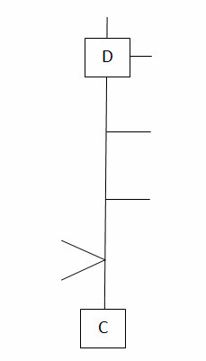
- You will walk from point "C" to point "D", following the second straight-line map below.
- An intersection is defined as a cross-walk with markings on pavement or an intersecting driveway.
To find your start location (point "A") go to the posted coordinates. There you will find a brass medallion (Note – there is no parking at the posted coordinates. You should park at the suggested parking waypoint and walk to the coordinates).
On the medallion you will find a 10 digit number. Disregard the hyphens in the number. Record the numbers in the table

- Waypoint "A" on the map is the center of an intersection.
- Waypoint "A" = N 41 48. " [ H ] [E-J] [ F ] W 088 0 [ L ]. [F+H] [ N ] [ J ].
- Leave the intersection on a heading of J L K. Best if you know what that direction is before getting there with your car.
Map 1 Driving

- Wayoint "B" on the map is the center of the last intersection.
- When you reach Waypoint "B" make a note of the total miles driven. Then park your car in a legal parking spot.

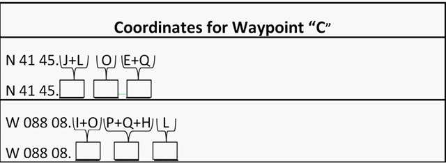
- From the numbers gathered, calculate the coordinates for waypoint "C" the start of the walking map.

Map 2 Walking

- Waypoint "C" is the center of a sidewalk
- Go to waypoint "C"
- Make your heading approximately (M) (J+L) (N) and follow map 2 to waypoint "D"
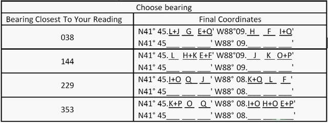
- At waypoint "D", get the bearing to waypoint "C"
- Use the table below to complete the calculation of the coordinates to cache location.

To Log This Cache:
- Go to final coordinates. Locate the marker on the North side of the path, which has a word that starts with "LAND" (Note - that is not the full word).
- Message/Email us the the significance of this marker
The following will be cause for deleting your log:
- Failure to message/email your answer
- Posting of any images of the cache location or images along the route
- Any spoilers included in your log. There must not be any reference to what this cache is about. Feel free to simply state "Found It" or how far off the your calculated coordinates were from the marker (reception can be bad in the area).
Examples Of How To Read Map
