De la place du Canal de Bourgogne dans l'Auxois
Which place take canal of Burgundy in the Auxois?
Partout où l'Homme a été confronté au sol ou au sous sol, il en a exploité les ressources, il l'a adapté et s'y est adapté en se pliant à ses contraintes, celle du relief, de l'eau, et de la pierre,etc...
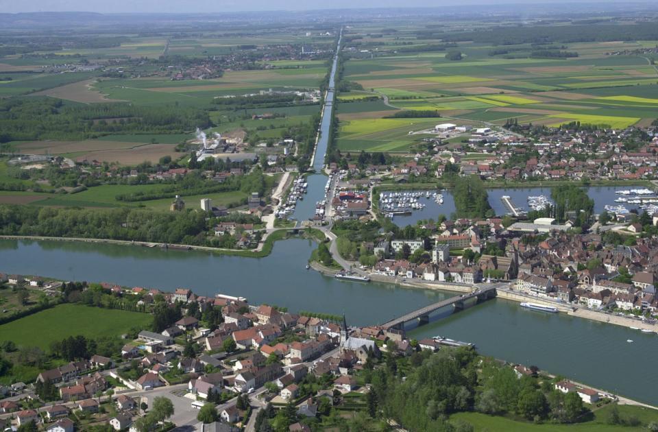
Depuis cette station de lecture il est possible d'observer un paysage façonné par l'Homme selon les principes énoncés ci dessus singulièrement avec le passage du canal de Bourgogne.
De manière générale, la présence de calcaire en Auxois, fait naître une multiplicité de sources à flanc de coteaux, plus particulièrement au pied des falaises du Haut-Auxois.
Cette organisation caractéristique des paysages du Pays de l’Auxois Morvan est due à la dépression péri-morvandelle. Ainsi, l’Auxois constitue « un îlot de fertilité enfermé entre les terres froides et granitiques du Morvan au Sud-ouest, et les terres sèches et calcaires du Châtillonnais au Nord-est
Al’inverse, le sous-sol du Morvan est propice à la stagnation de l’eau, créant ainsi des prairies marécageuses (appelées les « mouilles ») et des étangs.
On rencontre ainsi une dualité géologique entre deux entités fortes :
– D’un côté, l’Auxois, qui correspond à une région géologique spécifique (pendant la période jurassique du lias, entre 205 et 175 millions d’années, qui a donné des sous-sols principalement marneux et argileux, ainsi qu’une dalle de calcaire gris-bleu) ;
– De l’autre, le massif de Morvan, qui a subi de nombreuses transformations physiques causées par l’érosion. Seule une petite partie du Morvan se trouve en Côte-d’Or et concerne le territoire du Pays de l’Auxois Morvan (cantons de Saulieu, Précy-sous-Thil et de Liernais). Comme pour l’ensemble du massif du Morvan, le sous-sol y est essentiellement cristallin (présence de granite et de gneiss).
Cette rencontre entre le granite et l’argilo-calcaire, se retrouve dans les paysages et dans l’architecture du Pays.
Un des grands traits qui caractérise l’hydrologie de l’Auxois Morvan, est plus une construction humaine que ‘’naturelle’’ : c’est le canal de Bourgogne. Celui-ci traverse 6 cantons sur 90 km.
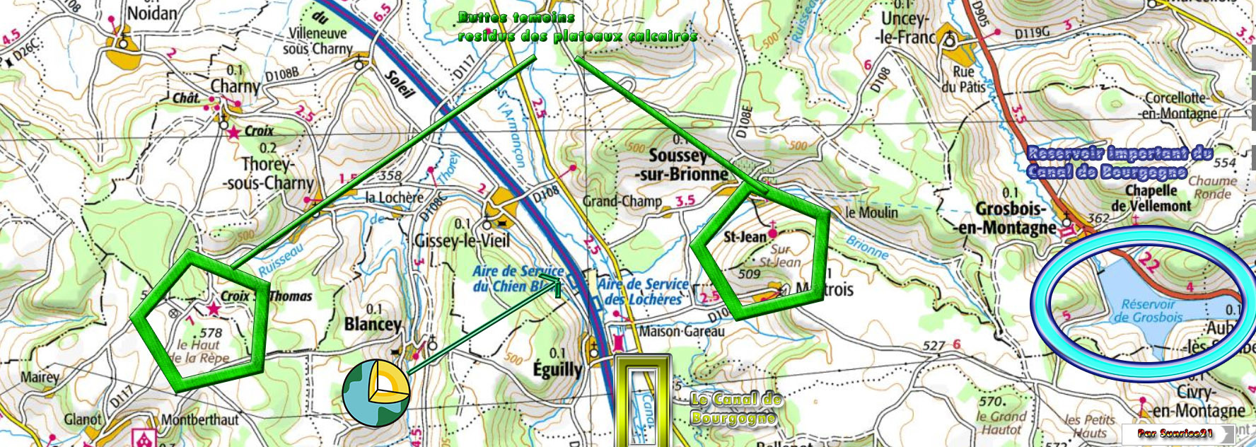
Le canal de Bourgogne représente une emprise sur le paysage et l’environnement. Il s’adjoint 6 réservoirs, dont l’eau est prélevée dans trois rivières. Son alimentation en eau est assurée dans ses parties les plus élevées par 5 réservoirs reliés au canal par des rigoles d'une longueur totale d’environ 70 km. D’un côté, les réservoirs de Grosbois-en-Montagne (8,6 millions de m²), de Chazilly (5 millions de m²) et de Cercey (3,5 millions de m²), se déversent dans le bief de partage de Pouilly-en-Auxois. La rigole du réservoir de Grosbois traverse la montagne de Soussey par un souterrain long de 3 705 m.
Les données naturelles initiales ont profondément été modifiées par de nombreux aménagements au cours des siècles, tant le franchissement du Seuil de Bourgogne a imposé de multiples travaux, routiers, autoroutiers, fluviaux et ferroviaires
Ainsi, Le Canal de Bourgogne franchit le Seuil de Bourgogne par l’Auxois à 378 m. par un célèbre tunnel souterrain appelé « voûte » de 3,3 km (J.F.Bligny, 2009, pp. 63 à 80) Mais à Buffon il se détourne de la vallée de l’Armançon car cette dernière traverse au niveau de Semur en Auxois un défilé dans les granites du Morvan beaucoup trop étroits et trop durs pour laisser place au passage d’un canal. Il était en effet préférable de creuser à Pouilly en Auxois un tunnel de 3,3 km dans les calcaires jurassiques.
Cependant, l’encaissement de l’Armançon dans ces granites a permis en amont de Semur de construire un lac de barrage de 3 millions de m3 à Pont et Massène pour contribuer à alimenter côté Bassin Parisien le Canal de Bourgogne.
La construction du Canal de Bourgogne, effectuée de 1772 à 1832 a permis un véritable exploit historique : établir une communication fluviale entre l’Océan Atlantique, la Manche et la Méditerranée.
Wherever Man has been confronted with the soil or underground, he has exploited the resources, adapted and adapted to it by adapting himself to his constraints, that of relief, water, and Stone, etc ...
From this reading station it is possible to observe a landscape shaped by man according to the principles stated above singularly with the passage of the Canal de Bourgogne.
In general, the presence of limestone in the Auxois, gives rise to a multiplicity of springs in hillsides, more particularly at the foot of the cliffs of Haut-Auxois.
This characteristic organization of the landscapes of the Pays de l'Auxois Morvan is due to the peri-morvandel depression. Thus, the Auxois constitutes "an island of fertility enclosed between the cold and granitic lands of the Morvan to the southwest, and the dry and calcareous lands of the Châtillonnais to the northeast
On the other hand, the subsoil of the Morvan is conducive to the stagnation of water, creating marshy meadows (called "wetlands") and ponds.
There is thus a geological duality between two strong entities:
On the one hand, the Auxois, which corresponds to a specific geological region (during the Jurassic period of the lias, between 205 and 175 million years ago, which gave mainly marly and clayey subsoils, Gray-blue limestone slab);
- On the other hand, the Morvan massif, which has undergone many physical transformations caused by erosion. Only a small part of the Morvan is in Côte-d'Or and concerns the territory of the Pays de l'Auxois Morvan (cantons of Saulieu, Précy-sous-Thil and Liernais). As for the whole of the Morvan massif, the subsoil is essentially crystalline (presence of granite and gneiss).
This encounter between granite and clay-limestone, is found in the landscapes and in the architecture of the Country.
One of the main features that characterizes the hydrology of the Auxois Morvan is more a human than a "natural" construction: it is the Burgundy canal. It crosses 6 cantons over 90 km.
The Burgundy Canal represents a grip on the landscape and the environment. It has 6 reservoirs, the water of which is taken from three rivers. Its water supply is ensured in its highest parts by 5 reservoirs connected to the canal by channels of a total length of about 70 km. On the one hand, the reservoirs of Grosbois-en-Montagne (8.6 million m²), Chazilly (5 million m²) and Cercey (3.5 million m²) Pouilly-en-Auxois. The gully of the Grosbois reservoir crosses the Soussey mountain by an underground passage 3 705 m long.
Initial natural data have been profoundly modified by numerous developments over the centuries, as the crossing of the Seuil de Bourgogne has imposed multiple works, road, motorway, river and railway
Thus, the Canal of Burgundy crosses the Seuil of Burgundy by the Auxois to 378 m. By a famous underground tunnel called "vault" of 3.3 km (JFBligny, 2009, pp. 63 to 80) But in Buffon it turns away from the valley of the Armançon because the latter crosses at the level of Semur in Auxois Defiled in the granites of the Morvan much too narrow and too hard to make way for the passage of a canal. Indeed, it was preferable to dig a 3.3 km tunnel in the Jurassic limestones at Pouilly en Auxois.
However, the collection of the Armançon in these granites enabled Semur to build a 3 million m3 dam reservoir at Pont and Massène to help supply the Bassin Bourgogne.
The construction of the Canal of Burgundy, carried out from 1772 to 1832, enabled a real historical feat: to establish a river communication between the Atlantic Ocean, the Channel and the Mediterranean.
Sources
|
infoterre.brgm.fr
http://www.persee.fr/doc/ingeo_0020-0093_1937_num_2_3_6327
http://www.bassin-armancon.fr/fic_bdd/pdf_fr_fichier/14129308530_2014_0605_Gerard_MOTTET_Etude_du_bassin_hydrographique_de_l%5C_Armancon.pdf
Lacs, forets et rivieres de Bourgogne, Edition Mars et Mercure, M Amiot et A Brunaud p 56
http://www.cen-bourgogne.fr/
|
Rappel concernant les « Earthcaches »: Il n'y a pas de conteneur à rechercher ni de logbook à renseigner. Il suffit de se rendre sur les lieux et d'éxécuter les requêtes du geocacheur.
Loguez cette cache "Found it" et envoyez-moi vos propositions de réponses soit via mon profil, soit via la messagerie geocaching.com (Message Center), EN PRECISANT LE NOM ET CODE GC DE LA CACHE et je vous contacterai en cas de problème.
Il est aussi apprécié d'avoir des photos des géocacheurs sur les lieux des EarthCache. Sentez vous inspiré de poster des photos de vous lors de cette visite ( optionnelle mais sympa)
---
Reminder concerning "Earthcaches": there is neither a container to look for nor a logbook to sign.
Log in this cache " Found it " and send me your answers proposals or via my profile or via geocaching.com messaging (Message Center ) , BY PROVIDING THE NAME AND GC CODE OF THE CACHE and I will contact you in case of problems .
We also enjoy seeing photographs of people visiting this EarthCache. Please feel free to log photos of your visit...(this is entirely optional but funny)
Grâce à votre observation et aux panneaux d'informations, répondez aux question ci dessous:

With your observation and information panels, answer the questions below:
QUESTIONS
| Sous quelle formation geologique a été construit le Canal depuis votre point d observation ? |
Under what geological formation was the Canal built from your observation point? |
| Quelles buttes ( autre que celles du descriptif) est il possible d'observer ? |
What mounds (other than those of the descriptive) is it possible to observe? |
| Qu'a été construit à Gissey en rapport avec le canal? Avec quelle roche? |
What was built at Gissey in connection with the canal? With wich rock ? |
| Facultatif : Une photographie ? |
Optionnal : A photo ? |