
Rocks on the surface of the earth can reveal many "secrets" about the past; you only have to take a close look at them. For example, grinding traces can be an indication of the activity of an ice-age glacier, or fossil imprints in a rock can give information about extinct ancient organisms. And wavy surface structures in the stone – so called ripple marks - point to the presence of running water million years ago. How these ripple marks are created and how they can differ is the subject of this EarthCache and should be illustrated by an example at the bridge at Fassfern.
Different forms of ripple marks
Ripple marks are sediment structures usually made of a sandy material and indicate agitation by water (currents or waves) or wind. Depending on the development there are two basic forms of ripple marks - the symmetrical and asymmetrical ripple marks.
Symmetrical ripple marks (also called wave-formed or bidirectional) are formed when the flow oscillates over the sandy/sedimentary ground. This means that the flow is alternately coming from different directions. So the the reciprocating movements of the waves create symmetrical waveforms with equal slopes on the ground.
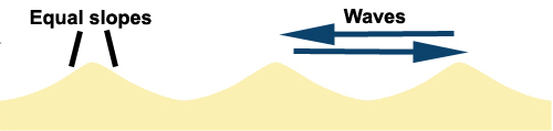
Symmetrical ripple marks
To form asymmetrical ripple marks (also called current or unidirectional) it needs a constant flow from one direction. The result is a structure with parallel waveformes, in which the up-current side is flat and slowly rising, while the down-current side drops steeply. This special form makes it possible to determine the direction of an ancient current.
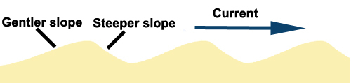
Asymmetrical ripple marks
When viewed from above ripple marks can show a variety of forms. They can be relatively straight or sinuous – so called straight ripples (a) marks or sinuous ripples marks (b) – or even form a pattern of unconnected arcuate forms – named linguoid ripple marks (c). The relationship between these types is to be related to the duration of the flow and its velocity. Straight ripples – for example - tending to evolve into linguoid forms through time and at higher velocities.
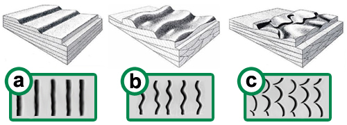
Different types of ripple marks: a) straight b) sinuous c) linguoid
EarthCache
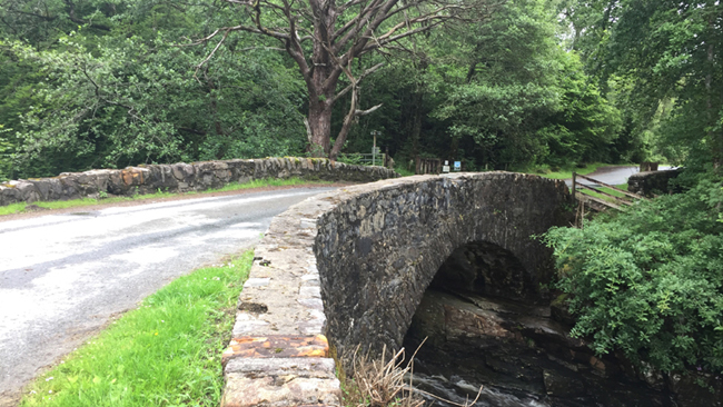
This EarthCache leads you to Fassfern bridge, where you will find an example for this special geological phenomenon. Here you can spot ripple marks in a hard Moine schist, which is visible at one of the riverbanks. Originally the schist was sandstone, which was deposited close to an ancient sea-shore, a billion years ago. The sandstone, a sedimentary rock, was deeply buried beneath the Caledonian mountain range and was subjected to elevated temperatures and pressures for millions of years. Under this conditions a process called “metamorphism”, altered the mineralogy, texture, and chemical composition of the sandstone and recrystallized it to form schist, a metamorphic rock, without destroying the ripple marks.
All conclusions for this EarthCache can be drawn from your on-site observations at Fassfern bridge and with the help of the listing-texts and -graphics. There is no need to climb down the bridge! All you need is to look over the edge of the bridge! You can park your vehicle close to the listing-coordinate at a parking area on the western side of the road.
To log this EarthCache you need to answer to the following questions:
Questions & Tasks:
- Have a look over the edge of the bridge to the nearby river banks. On which side of the bridge can you spot ripple marks in the stonelayers of the river bank? At the northwestern, northeastern, southwestern or southeastern side?
- Describe the stonelayers with ripple marks at this place! What kind of ripple can you discover here? Are they symmetrical or asymmetrical?Straight, sinuous or linguoid?
- What can be concluded based on the ripple? What can they tell us about the past of this area?
- Take a picture of yourself, your team and/or a personal item (for example your GPS), which clearly shows that you actually visited Fassfern Bridge and place it on your log! Please don't spoil any answers with your photo(s)!
Please send your answers via mail or message-center via my profile. After(!) you have sent the answers to me, you can directly log the cache as found. If there are any problems, I will contact you. Logs without a photo and/or answers are deleted without warning!
Additional information:
- Watch out while leaning over the edge of the bridge!
- You don’t have to climb down the bridge!!!
- Watch out for the passing traffic!
- The ripple marks cannot be spotted neither by night nor by snow!
Sources
Fettes, D.J. & Harris, A.L., Synthesis of the Caledonian Rocks of Britain, 1984
Goudie, Andrew; Physische Geographie, Spektrum, 1995
Leser, Hartmut; Wörterbuch Allgemeine Geographie, 1997
McCann, Tom, Geologie im Gelände, 2015
Reineck, H.-E. & Singh, I.B., Depositional Sedimentary Environments, 1978 ⊃1;
http://lochabergeopark.org.uk/explore-lochaber/lochaber-geotrails/road-to-the-isles/ (08/2017)
https://en.wikipedia.org/wiki/Ripple_marks (08/2017)
Own photos