 L'image conservée d'un fond marin
Une page de l'histoire de la Terre :
L'exploitation du grès à Hettange-Grande a permis aux géologues d'étudier et de reconstituer l'histoire d'une période des temps géologiques située il y a environ 200 millions d'années.
À cette époque, au début du Jurassique, les terres émergées ne sont composées que de deux grands continents Laurasia et Gondwana, séparés par un étroit bras de mer, la Téthys, et entourée d'un immence océan recouvrant le reste du globe, la Panthalassa.
Alors que ces deux continents s'éloignent l'un de l'autre (par le jeu de la tectonique des plaques), la mer théthysienne se déploie vers l'ouest entre les massifs montagneux environnants, plus ou moins émergés à l'époque (Bohême, Eifel, Hunsrück, Ardenne et Massif Central). Le climat est alors tropical.
C'est dans cet environnement, à l'interface entre les milieux marin et continental, que se sont formées les roches visibles sur le territoire de la réserve naturelle.
Partons à présent à la découverte de ce fond marin !
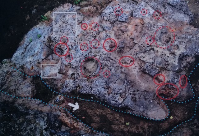
Sur la discontinuité face à vous, différentes structures sont visibles : des petites déformations circulaires liées à l'activité des organismes marin à l'hettangien et des cavités apparues suite à la disparition de nodules ferrugineux.
Rappel concernant les « Earthcaches »: Il n'y a pas de conteneur à rechercher ni de logbook à renseigner. Il suffit de se rendre sur les lieux et d'exécuter les requêtes du propriétaire de la cache. Loguez "Found it" et envoyez-vos réponses au poseur soit par mail ou soit par la messagerie geocaching.com (Message Center), je vous contacterai en cas de problème. Bon Earthcaching!
Questions :
1. Quel est le nom des deux types de structures visibles ici ?
2. Comment a été formée la rigole ?
3. Comment se sont formés les nodules ferrugineux ?
4. À quoi correspond chacune des zones sur la photo ? (légende du panneau d'information)
Optionnel : une photo de vous et/ou de votre GPS sur les lieux
 The conserved image of a seabed
A page in the history of Earth:
The exploitation of sandstone at Hettange-Grande allows geologists to study and reconstruct the history of a period of the geological times: there are about 200 million years.
At that time, in the early Jurassic period, emerged lands were composed of only two large continents, Laurasia and Gondwana, separated by a narrow inlet, the Tethys, and surrounded by an imminent ocean covering the rest of the globe. Panthalassa.
As these two continents moved away from one another (tectonic plates movement), the 'théthysienne' sea unfolds to the west between the surrounding mountainous massifs, more or less emerged at that time (Bohemia, Eifel, Hunsrück, the Ardennes and Massif Central). The climate was then tropical.
It is in this environment, at the interface between the marine and continental environments, that rocks which are visible on the territory of the nature reserve were formed.
Let's start now to discover this seabed!
Sur la discontinuité face à vous, différentes structures sont visibles : des petites déformations circulaires liées à l'activité des organismes marin à l'hettangien et des cavités suite à la disparition de nodules ferrugineux.
On the discontinuity vis-à-vis you, different structures are visible: small circular deformations linked to the activity of the marine organisms to the hettangien and cavities formed after the disappearance of ferruginous nodules.
Reminder on "Earthcaches": There is no container or logbook on the given coordinates. Just visit the site and answer the questions by e-mail or by the Message Center.There is no need to wait for my reply, feel free to log immediately after. If the answers are incorrect, I will let you know. Happy caching!
Questions :
1. What are the names of the two types of structures visible here?
2. How was formed the rivelet?
3. How were formed ferruginous nodules?
4. Give me the meaning of each aera of the following photo. (legend on the information board)
Optional: a photo of you and/or your GPS on the spot