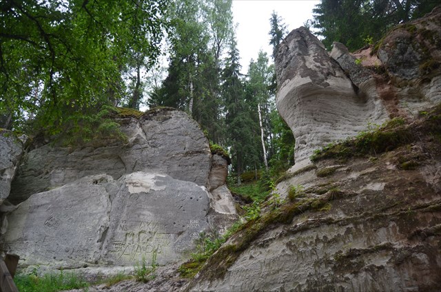
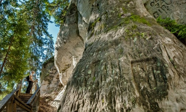
Sietiņiezis (arī Sietiņš un Sietnis) ir aptuveni 400 metrus garš un līdz 15 m augsts baltā devona smilšakmens atsegums, ģeoloģiskais un ģeomorfoloģiskaisdabas piemineklis Gaujas labajā krastā, Vaidavas pagastā, Kocēnu novadā, Latvijā. Lielākais baltā smilšakmens atsegums Baltijā. Atrodas Gaujas nacionālā parka teritorijā apmēram 1 km uz austrumiem no "Sietiņu" mājām un 16 km attālumā no Valmieras. Pirms sabrukšanas 20. gadsimta 70. gados uz Sietiņieža virsotni vedusi arka (dižākā dabiskā arka). Velve bijusi līdz 4 m plata. Sietiņieža nosaukums, iespējams, radies no ieža izskata, kura virsma klāta ar savvaļas bišu veidotiem caurumiņiem, kas veido it kā "sietiņu". Objekta apkārtne labiekārtota ar tūrisma infrastruktūru.
Viens no Latvijas skaistākajiem iežiem, dēvē arī par vienu no augstākajiem. Devis nosaukumu tuvējām Sietiņu mājām, nosaukums cēlies no tā, ka iezis bagātīgi izrobots. Ārkārtīgi daudzveidīgs, te daudzas dīvainas formas, alas, stabi, nišas, veidojas arka, skatu punkts no augstākās vietas.
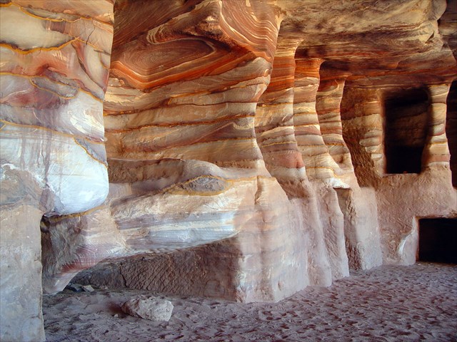
Pirmais posms - vienlaidu, apakšā gandrīz vertikāla 200 m gara, ap 13 m augsta lēzeni ieliekta krauja, kur no ūdens līmeņa līdz 6 m augstumam atsedzas dzeltenīgi balti Gaujas svītas smilšakmeņi. Atsegumā redzamas noslīdeņu krokas, dubults slīpslāņojums, melni smago minerālu koncentrātu slānīši, izskalojuma virsmas un māla olīši. Virs tiem seko 6 - 7 m augsts trešās terases aluviālo sanesu slānis. Šī daļa radusies Gaujai noārdot senielejas trešo, smilšakmeņos iegrauzto terasi.
Otrais posms sākas vairāk uz dienvidiem. Te smilšakmens atsegumi ir tālāk no upes. Kraujas apakšējā daļa apaugusi ar krūmiem un kokiem, no upes gandrīz neredz. Šī daļa ir saposmota, vietām klints līdz 15 m augsta. Daudz dažāda platuma plaisas. Tās bojā klinšu kāpēji, pa tām kāpelējot, kaut arī te kāpelēt aizliegts. Ir ierīkotas takas pa augšu un apakšu. Te atradās Latvijas dižākā dabiskā arka. Blakus atrodas ala, kam abi gali vaļā, kā arī 15 m augsts smilšakmens stabs. Bez tam jāpiemin arī Velna papēdis - plaisu ierobežots smilšakmens izcilnis ar platformu galā, kas ar laiku var kļut par smilšakmens stabu. Tālāk dienvidos - sengrava, kas beidzas ar lielu vertikālu trīsstūrveida plaisu. Sietiņiezī atrodamas divas prāvas nišas. Sufozijas piltuves, no kurām lielākā ir 7 m dziļa, diametrs 8 metri.
Kopumā atsedzas 34 m smilšakmeņu slāņkopa, kas veido Gaujas svītas augšdaļu un Amatas svītas apakšējo, 7,8 m biezo, irdeno slāni. Ziemeļdaļā atsedzas senākie ieži, te daudz māla saveltņu, smago minerālu kārtiņas. 150 m tālāk ir neliela okera atradne, ko veidojuši avoti.
Sietiņieža dabiskā arka (nepastāv) - sabruka 1975. gada vasarā. Velve bijusi 4 m plata. Bijusi izcilākais Sietiņieža veidojums. Bijusi daudzkārt lielāka par Liepas Ellītes arkām. Šī arka bija izveidojusies šaurā, upei paralēlā smilšakmeņu šķautnē, kuru no ielejas nogāzes norobežo sengrava ar piltuvveida padziļinājumu. Arkas augstums no nogāzes pamatnes bija 7 m. Caur to gāja 5 m augsta un līdz 8 m plata eja, kuras velves platums bija 4 m, biezums 2 m. Pāri arkai gāja norobežota tūristu skatu taka. Arka palielinājās, nogrūstot šmilšakmeņiem no velves apakšas, ko paātrināja uzrakstu skrāpētāji. Tagad arkas vietā smilšakmens šķautnē liels robs. Tepat līdzās veidojas jauna arka. (10. avots).
Sietiņieža Velnala - Sietiņieža D daļas ziemeļos, pie iegruvuma, 10,5 m gara. Ala unikāla ar to, ka tai abi gali vaļēji - te veidojas arka netālu no bijušās Sietiņieža arkas vietas. Pie ieejas ala ir plaša un augsta (5 m plata, 4 m augsta, 2,5 m dziļa), tālāk sašaurinās (30 cm augsta, 70 cm plata), līdz otrā pusē atkal veido piltuvi (dziļums 8 m, platums līdz 13 m), kas uztver visus sniega un lietus ūdeņus, kas tekot caur alu, to paplašina. Alas augstums 1,2 m, grīdas platība 25 m2.
Stabs - blakus iegruvumam un alai atgādina milzīgu, 15 m augstu "cukurbieti". Tas stāv vertikāli, ar vienu sānu nedaudz turēdamies pie klints sienas.
Divas nišas D daļā.
Trīsstūrveida plaisa - niša. Sietiņiezi te šķērso interesanta sengrava, kas smilšakmeņu sienā izveido lielu robu. Roba apakšējā daļā smilšakmenī radusies liela, vertikāla trīsstūrveida plaisa.
DEVONS
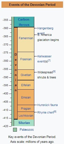
Devons ir ceturtais ģeoloģiskais periods paleozoja ērā, kurš ilga apmēram 56 miljonu gadu (no 416 līdz 359,2 Ma). Tam dots Devonas (Anglijā) nosaukums, kur pirmoreiz šī perioda ieži tika pētīti.
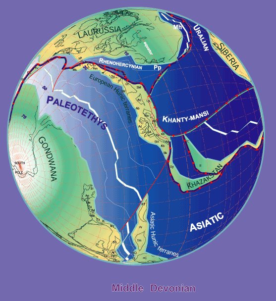
Devona perioda nogulumi veidojās Kaledonijas krokošanās cikla beigās, kad notika plašu Zemes garozas rajonu celšanās. Ar to ir saistīta biezu terigēno nogulumu, t.s. seno sarkano (angl. Old Red) smilšakmeņu slāņkopu veidošanās. Vidējā un sevišķi vēlajā devonā ģeosinklināļu apgabalos un platformās norisinājās galvenokārt Zemes garozas grimšanas procesi. Epikontinentālās jūras klāja lielu Austrumeiropas un Ziemeļamerikas, Austrālijas u.c. platformu daļu. Devonā raksturīga arī vulkānisma aktivizācija atsevišķos ģeosinklināļu rajonos.
Arī Latvijas teritorijā ir plaši pārstāvēti devona nogulumi, kas atrodas tieši zem kvartāra nogulumiem. Tie veidojās sakarā ar to, ka zemes virsmu mūsdienu Latvijas teritorijā virs Baltikas kontinenta pamatklintāja klāja sekla jūra, kurā veidojās biezs nogulumiežu slānis. Tikai Latvijas dienvidrietumu daļā devona nogulumus sedz vēlāko ģeoloģisko periodu slāņkopas.
SMILŠAKMENS
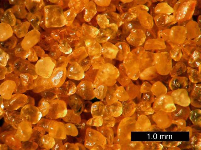
Smilšakmens ir drupiezis, kas ir veidojies, sacementējoties smiltīm. Smilšakmeņus klasificē pēc graudu sastāva — izšķir kvarca, kvarca-laukšpatu, arkozos, polimiktos un tufogēnos smilšakmeņus. Tāpat tos var klasificēt arī pēc graudu lieluma, ģeoloģiskā vecuma, cementa sastāva un derīgā komponenta.
Smilšakmens atsegumi ir vērojami pie ūdens, piemēram, upju krastos. Dažkārt lieli smilšakmens apjomi ir atrodami vietās, kur agrāk ir bijušas nelielas jūras.
UZDEVUMS
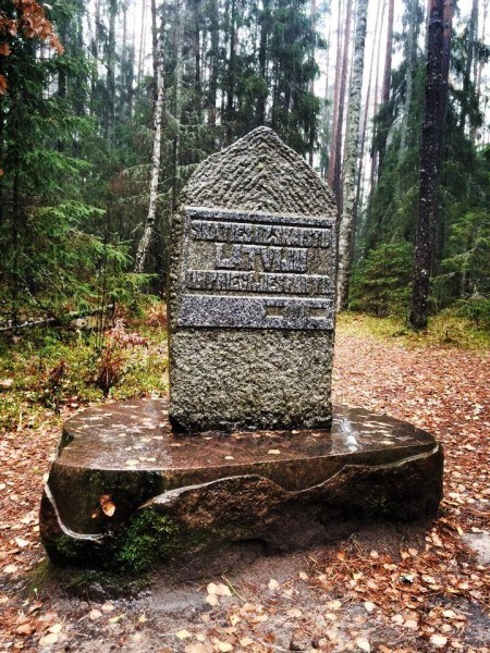
1. No kura gada Sietiņiezis atrodas Valsts aizsardzībā?
2. Kurā gadā uzstādīja granīta piemiņas plāksni?
3. Kurā gadā sabruka arka?
4. Kāpēc šo periodu, kad veidojusies klints, sauc par Devona periodu?
5. Kāda struktūra ir klintij? Rupja, smalka vai vidēja raupjuma?
6. Kas īpašs notika uz Zemeslodes Devona periodā?
7. Bildīte ar Tevi pie piemiņas plāksnes padarīs tavu ierakstu skaistāku!
Atbildes sūti uz manu profilu, es apsolos atbildēt pēc iespējas ātrāk.
ENGLISH
The Sietiņiezis (also called Sietinš and Sietnis) is a white Devon period sandstone, about 400 meters long and up to 15 meters high, a geological and geomorphological monument on the right bank of the Gauja River, Vaidavas parish, Kocēni region, Latvia. The largest white sandstone outcrop in the Baltics. Located in the territory of the Gauja National Park, about 1 km east of the "Sietiņi" house and 16 km from Valmiera. Before the collapse of the 70s of the 20th century, there was an arch (the largest natural arch) was driven to the top of Sietiņiezis. Velve was up to 4 m wide. The name of the sieve is probably derived from a rocky look, whose surface is surrounded by bee-shaped holes. The surrounding area is well-equipped with a tourist infrastructure.
One of Latvia's most beautiful rocks is also called one of the highest. Har gived name to the nearby Sietiņi houses, the name comes from the fact that the rock is abundantly excavated. Extremely diverse, there are many strange shapes, caves, poles, niches, arches, a point of view from the highest place.
The first stage consists of a continuous, bottom almost vertical 200 m long, about 13 m high, flattened concourse, where the yellowish-white Gauja's sandstone is revealed from a water level up to 6 m high. At the outskirts, there are ductile folds, double sill, black smelter of heavy mineral concentrates, scouring surfaces and clay olives. Above them is a 6 to 7 m high third layer terraced alluvial layer. This part was created by the river Gauja to demolish the third, sandstone-covered terrace of the ancient valley.
The second stage begins more south. The sandstone outcrops are further from the river. The bottom of the cliff is overgrown with shrubs and trees, almost not seen from the river. This part is tufted, places rock up to 15 m high. Lots of different latitude cracks. They destroy rock climbers by climbing them, even though climbing here is forbidden. Trails are arranged up and down. Here was the largest natural ark in Latvia. Nearby there is an open-air cave and a 15-meter sandstone pillar. In addition, the Devil's Heel - a cracked sandstone with the platform on top, which may eventually become a sandstone pillar, should also be mentioned. Further south, the valley ends with a large vertical triangle. There are two niches in Sietiniezis. The Sufic Funnels, of which the largest is 7 meters deep, has a diameter of 8 meters.
In total, 34 m of sandstone layer is discovered, forming the upper part of the Gauja suite and the lower, 7.8 m thick, undiluted layer of the Amata suite. The northern part reveals the oldest rocks, there are many clay sparrows, heavy mineral layers. 150 m further is a small ocher deposit made by sources.
The Sietiniezis natural arch (does not exist) collapsed in the summer of 1975. Arch was 4 m wide. It was the finest form of Sietiniezis. It was many times larger than the Liepas Ellite's arches. This arch was formed on a narrow, river parallel to the edge of the sandstone, which is surrounded by valley slopes with a funnel recess. The height of the arch from the base of the slope was 7 m. It was followed by a 5 m high, and up to 8 m wide passage with a 4 m wide chassis, a thickness of 2 m. Behind the archway was a narrow tourist track. The arch grown, cutting off the sandstone from the bottom of the vault, accelerated by the scrapers. Now there is a big rub in the edge of the sandstone. There is a new arch next to it.
Sietinieza Velnala - Northern part of Sietiņiezis D, at the embankment, 10.5 m long. The area is unique with the fact that both of them can be loose - this is where the arch is formed near the former Sietiniezis arch. At the entrance, the cave is wide and high (5 m wide, 4 m high, 2.5 m deep), then narrow (30 cm high, 70 cm wide), until the other side again forms a funnel (depth 8 m, width Up to 13 m), which captures all the snow and rain waters that flow through the beer, extends it. Cave height 1.2 m, floor area 25 m2.
The stables are adjacent to the embankment and the cave resembles a huge 15-meter "sugar beet". It stands vertically, with one side slightly holding onto the rock wall.
Two niches in part D
Triangular gap - niche. Here Sietiniezis are crossed by an interesting walley, which creates a huge gap in the sandstone wall. In the lower part of the robot, a large, vertical, triangular gorge has appeared in the sandstone.
DEVONIAN
The Devonian is a geologic period and system of the Paleozoic, spanning 60 million years from the end of the Silurian, 419.2 million years ago (Mya), to the beginning of the Carboniferous, 358.9 Mya. It is named after Devon, England, where rocks from this period were first studied.
The first significant adaptive radiation of life on dry land occurred during the Devonian. Free-sporing vascular plants began to spread across dry land, forming extensive forests which covered the continents. By the middle of the Devonian, several groups of plants had evolved leaves and true roots, and by the end of the period the first seed-bearing plants appeared. Various terrestrial arthropods also became well-established.
Fish reached substantial diversity during this time, leading the Devonian to often be dubbed the "Age of Fish". The first ray-finned and lobe-finned bony fish appeared, while the placodermi began dominating almost every known aquatic environment. The ancestors of all four-limbed vertebrates (tetrapods) began adapting to walking on land, as their strong pectoral and pelvic fins gradually evolved into legs. In the oceans, primitive sharks became more numerous than in the Silurian and Late Ordovician.
The first ammonites, species of molluscs, appeared. Trilobites, the mollusk-like brachiopods and the great coral reefs, were still common. The Late Devonian extinction which started about 375 million years ago severely affected marine life, killing off all placodermi, and all trilobites, save for a few species of the order Proetida.
The palaeogeography was dominated by the supercontinent of Gondwana to the south, the continent of Siberia to the north, and the early formation of the small continent of Euramerica in between.
SANDSTONE
Sandstone is a clastic sedimentary rock composed mainly of sand-sized (0.0625 to 2 mm) mineral particles or rock fragments.
Most sandstone is composed of quartz and/or feldspar because they are the most resistant minerals to weathering processes at the Earth's surface, as seen in Bowen's reaction series. Like uncemented sand, sandstone may be any color due to impurities within the minerals, but the most common colors are tan, brown, yellow, red, grey, pink, white, and black. Since sandstone beds often form highly visible cliffs and other topographic features, certain colors of sandstone have been strongly identified with certain regions.
Rock formations that are primarily composed of sandstone usually allow the percolation of water and other fluids and are porous enough to store large quantities, making them valuable aquifers and petroleum reservoirs. Fine-grained aquifers, such as sandstones, are better able to filter out pollutants from the surface than are rocks with cracks and crevices, such as limestone or other rocks fractured by seismic activity.
Quartz-bearing sandstone can be converted into quartzite through metamorphism, usually related to tectonic compression within orogenic belts.
TASK
1. From which year Sietiņiezis is in the National Defense?
2. In what year were installed granite memorial plaques?
3. What year did the arch collapse?
4. Why is this period when the rock is formed, called the Devonian period?
5. What is the structure of the rock? Coarse, fine or medium roughness?
6. What happens so special on the Earth in Devonian period?
7. The picture with you on the memorial plaque will make your recording more beautiful!
Answers send to my profile, i will contact you.