Željnske jame
Željnske jame se nahajajo na območju gozdnega rezervata v bližini vasi Željne pri Kočevju. Največja značilnost jam je, da so zelo plitko pod površjem. Imajo tanek strop in številna naravna okna. zato si vse lahko ogledamo od spodaj in od zgoraj. Jamski stropovi so debeli le 2 do 5 metrov. So izjemno zanimiv, okrog 1600 m dolg vodoraven jamski sistem Rudniškega potoka z več vhodi. Potok se pretaka pod Kočevskim Rogom proti Podturnu, kjer se pojavi v potoku Radeščica, pritoku Krke. Sistem Željnskih jam je bil včasih prehoden in je imel značaj razvejanega tunela od Ciganskih jam do Jame pri koritu. Prehod skozi rove, po katerih teče Rudniški potok, danes onemogoča židko blato, ki je nastalo iz odloženega premogovega prahu. Kapniki so le na posameznih mestih v jami, saj temperatura zaradi prepiha ni stalna in se giblje od 6 do 12 °C. Jama je poleti zanimiva zaradi igre senc, pozimi pa v njej lahko vidimo ledene kapnike.
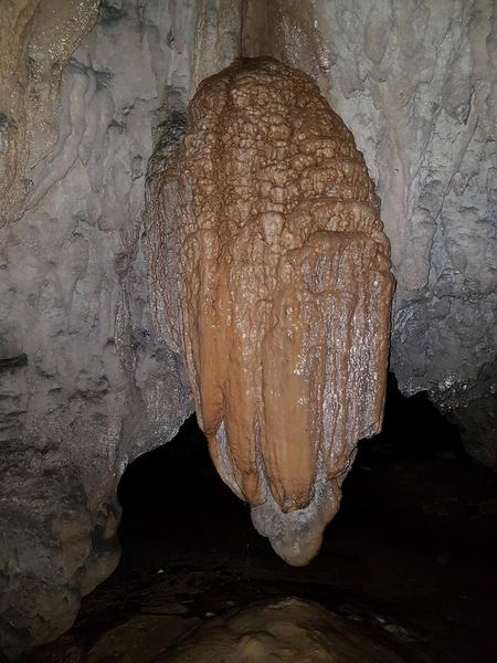
Kapnik v Stranski jami, april 2017
Za oznako teh jam uporabljamo množinsko obliko - Željnske jame. Ime je pojasnjeno ob vstopu v to kraško jamo. Potok je izdolbel jamo v tanko plast apnenca, ker pa jamski strop ni bil povsod enakomerno trden in debel, da bi zdržal lastno težo, je tako nastalo več udorov. Tako je jamski rov večkrat prekinjen, kar pomeni, da kompleks tvori večje število jam. Tem skalnim odprtinam pravimo naravna okna in mostovi. Za katero ime se odločimo, je odvisno, ali naredi na nas večji vtis odprtina ali skalni obok. V prvem primeru govorimo o oknu, v drugem pa o mostu. V Željnskih jamah je obilica obojega. Že takoj na začetku gremo pod širok obok (most) pod katerim je informacijska tabla, v večjo dvorano s stranskima oknoma. Rov vodi v temo, a se že na koncu sveti odprtina naslednjega podora. Šibka svetloba je dovolj, da se prebijemo skozi temni del, lahko pa si olajšamo pot z baterijsko svetilko. Pot se zvije čez s praprotmi in z drugim zelenjem poraščeni vrhnji del nekdanjega stropa in se mimo naravnega mostovja spet spusti v Veliko dvorano. Tu bi gotovo potrebovali svetilko, če ne bi bilo treh odprtin v stropu. Stožci skalovja pod njimi pojasnjujejo, da so to ostanki stropa. V najnižjem delu teče potok, črne usedline pa so ostanek premogovega prahu, ki ga je voda nanesla iz bližnjega premogovnika. Jamarji so raziskali še več delov jame, običajnemu obiskovalcu pa ne preostane drugega, kot da se vrne po isti poti. Do tako imenovanega Črnega rova pa je vseeno moč priti ob predhodni najavi pri članih Jamarskega društva Netopir iz Kočevja.
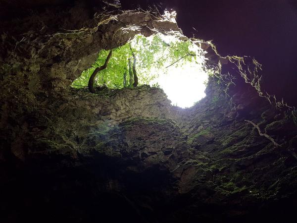
Naravno okno, julij 2017
Nekdaj pa so jame naseljevali Romi in jih uporabljali kot bivališče ali pa kot hlev za konje. Začetni del jamskega sistema Željnskih jam je tako dobil ime Ciganske jame, ki je tudi najbolj znan del jam. Jame povezujejo številni rovi, znana sta Črni in Blatni rov.
Jame so bile naseljene že v mlajšem paleolitiku - gravettienska kultura - za kar nam pričajo arheološki ostanki, ki potrjujejo, da je skoraj pred 20.000 leti v Ciganski jami živel ledenodobni človek. Med izkopavanji, ki jih je v istoimenski jami pod vodstvom Mitje Brodarja vršila SAZU med leti 1963 – 1976 so namreč našli ostanke oglja, živalskih kosti in preko 1400 predmetov. Največ je neuporabnih odbitkov, od kamenega orodja pa so pogosta strgala, kline, praskala ter nekaj koščenih šil, kar priča o lovski postojanki. Kosti alpskega svizca in severnega jelena potrjujejo, da je bila takrat klima prehladna za gozd. Pokrajina je imela značaj tundre, alpski ledeniki pa so segali daleč v doline.
Željnske jame so prvič popisali in narisali pred 250 leti. To je storil dvorni matematik in naravoslovec Jožef Anton Nagel, ki je prišel na Štajersko in Kranjsko, da bi tam preučil naravne znamenitosti in potem poročal o rezultatih svojih raziskav. Svoja spoznanja je opisal v delu z naslovom "Opis naravnih znamenitosti Kranjske".
V času turških vpadov je obzidje, ki je pred vhodom v Veliko dvorano vidno še danes, služilo kot obramba pred napadi. Med drugo svetovno vojno, pa so se tu skrivali prebivalci okoliških vasi pred bombardiranjem.
Željnske jame so na seznamu najpomembnejše naravne dediščine Slovenije in z odlokom Občine Kočevje razglašene za naravni spomenik lokalnega pomena. Zaradi številnih udorov so nastala številna naravna okna in mostovi, ki dajejo Željnskim jamam zaradi igre svetlobe, ki zato nastaja, poseben čar. Jame imajo zato več vhodov in so razmeroma lahko dostopne, vegetacija v njih pa je vzorčni primer vseh možnih oblik prilagajanja rastlin na življenje v odvisnosti od svetlobe.
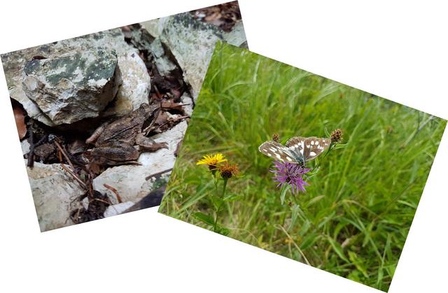
Vse posebnosti jamskega okolja izhajajo iz tega, da je jama bolj ali manj zaprt prostor, kjer je dokaj stalna temperatura, vlaga in tema. Zaradi tega v jamah ni zelenih rastlin, ki proizvajajo hrano za druga živa bitja. Vendar so se na te življenske razmere privadile različne živali, kot so pajki, kobilice, netopirji, žabe, in komarji, ki se v jame umikajo pred vročino.
Celoten jamski sistem je danes močno poškodovan. Lahka dostopnost jam je privabljala številne obiskovalce, ki so si svetili z baklami in zadimili sigo, lomili kapnike, pisali po stenah ali pa v jamah našli odlagališče za najrazličnejše odpadke. Premogov prah, ki ga je v jame naplavil Rudniški potok, je zamašil rove in prizadel nekdaj bogato podzemno favno. Tako je izginila tudi človeška ribica, ki jo sedaj iz podzemlja naplavijo le visoke vode.
Viri
- http://www.kocevje.info/zeljnske-jame/
- https://sl.wikipedia.org/wiki/%C5%BDeljnske_jame
- http://www.kam.si/izleti/zeljnske_jame_igre_svetlobe_in_teme.html
- Informativne table pred jamo
NALOGE ZA VPIS ZAKLADA
Svojo pot začnite na podanem parkirišču, kjer se odpravite po poti označeni z zelenimi oznakami za jame. Dodan je tudi trailhead
Za vpis tega zemeljskega zaklada boste morali najprej odgovoriti na spodnja vprašanja. Odgovore najdete na terenu, orientirajte se po dodanih waypoints. Odgovore nama pošljite preko sporočila na geocaching strani.
PRED VHODOM
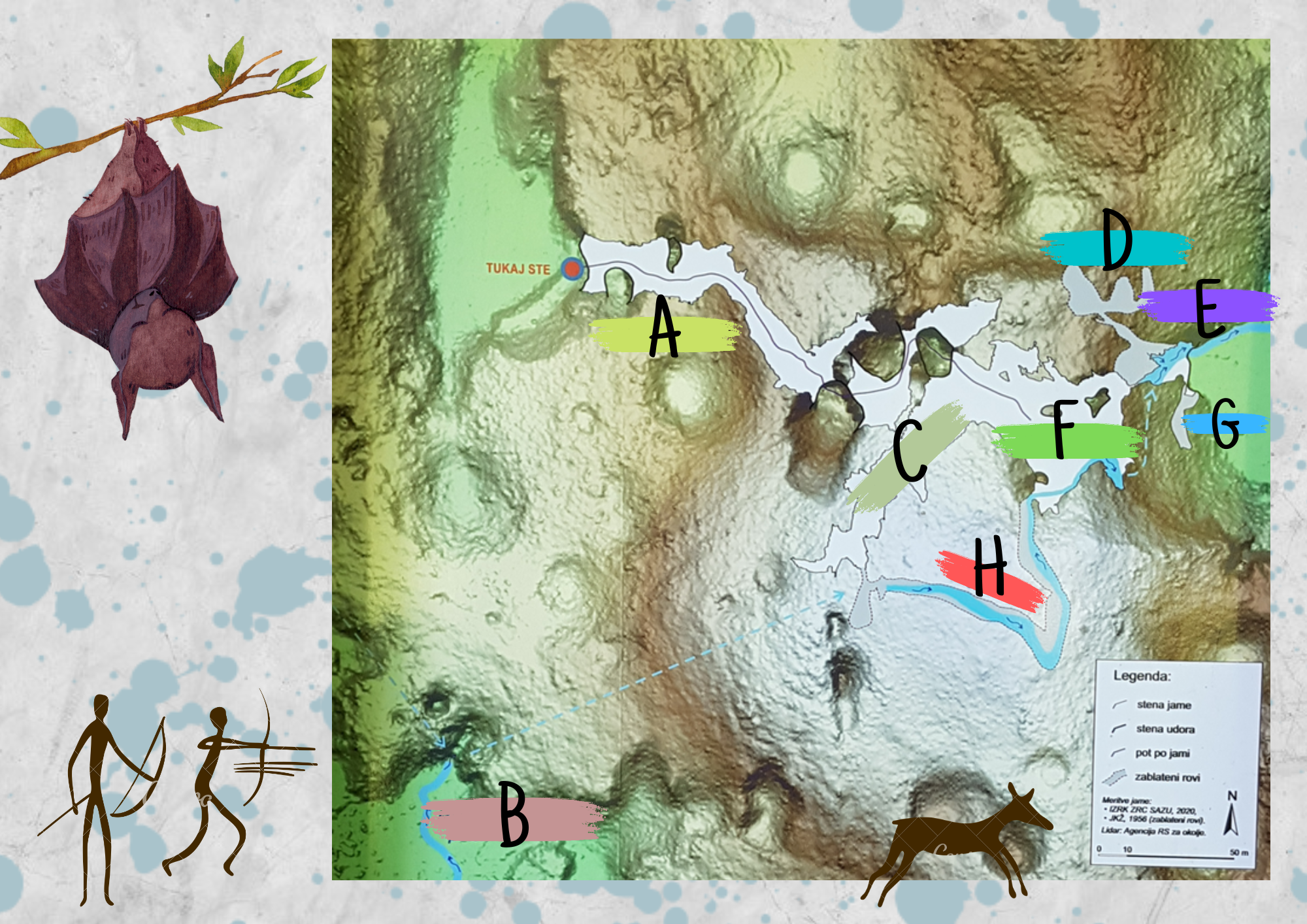
1. Tik pri vhodu najdeš tudi zemljevid območja. Izpolni spodnjo sliko (A - H).
VHOD V VELIKO DVORANO
2. Vstopi v Veliko dvorano. Oceni dolžino in širino največjih dveh oken v jami.
3. V jami boš opazil ograjen predel. Kaj misliš, da ograjuje? Pomagaj si z opisom zaklada
Ko odpošljete odgovore lahko zaklad takoj vpišete kot najden. Vsi logi brez spremljajočega emaila s pravilnimi odgovori bodo izbrisani brez predhodnega opozorila. Prav tako bodo izbrisani logi ali slike, ki bodo vsebovali odgovore na katerokoli izmed spodnjih vprašanj.
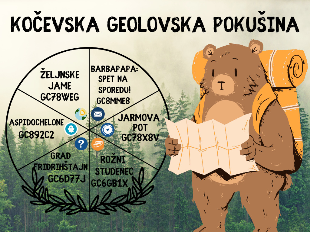
Ta zakladek je eden izmed šestih zakladov kočevske geolovske pokušine. Več informacij in seznam zakladov najdete TUKAJ. Če najdete vseh šest zakladov na seznamu, si lahko na svoj profil dodate spodnji banner (povezava posodobljena 31.3.2024), tako da si v opis svojega profila dodate besedilo:
<p style="text-align:center;"><a href="https://www.geocaching.com/plan/lists/BMBP5TX?sort=name&sortOrder=asc&skip=0&take=20" target="_blank"><img src=" https://img.geocaching.com:443/d3664d6e-34ae-458e-8d0f-0c34214886a7.png " alt="Kočevska geolovska pokušina banner: Please contact the owners if the image does not display or check if a new link has been added on the cache page (GC8MME8)." /></a></p>
Željne caves
Željne caves are located in a forest reserve near the village Željne. The cave's most unique attribute
is the fact they are located right below the surface. They have thin ceilings and numerous naturally
occurring windows. These allow us to view the cave system from above, not just from the inside. The
thickness of the ceilings is 2 to 5 meters. The caves are an approximately 1600 meters long
horizontal cave system, created by “Rudniški potok” (rudniški = of the mine, potok = creek) with
multiple entrances. In the past, the entire cave system was open so one could walk through it. Now,
the tunnels through which the creek still runs have become blocked by coal dust from a mine that
used to operate nearby (Now the Lake of Kočevje). Cave formations (stalactites, stalagmites) occur
in few areas of the cave, since the temperature is not constant and ranges from 6 to 12 degrees
because of a constant draft. During winter, some stalactites and stalagmites form from ice.
A cave formation in the Side cave, April 2017
When talking about the caves, we use the plural form – Željne caves, not cave. The reason becomes
apparent, when entering the caves. When the creek was carving out the caves in the thin layer of
limestone, the ceiling was weaker and thinner in some parts, becoming too heavy to hold its weight,
thus collapsing. This created many interruptions in the cave tunnel, which broke the single cave into
multiple caves. Places where the ceiling collapsed are known as windows and bridges (depending
on your perspective). Željne caves have plenty of both. Right from the start a person walks under an
arch (bridge), where an information board is located, and into a large chamber with side windows.
The chamber continues into darkness, but light coming from another window at the far end lets in
enough light to enable a person to walk through. The path continues over the collapsed remains of
the ceiling, which are now overgrown with ferns and other plant life. Walking past other natural
bridges, a person enters the Great chamber. A flashlight would be a must here, if it weren’t for the
three natural windows. Piles of rock beneath them are evidence of the collapsed ceiling. The lowest
part of the chamber is a creek bed, with black coal dust clearly visible. Cave explorers have
searched deeper, but for non-professionals the path ends here.
Natural window, July 2017
In the past, the caves were inhabited by the Roma and used as a place of residence or as a stable
for horses. The starting part of the cave system of Željne Caves was thus named the Gypsy Cave,
which is also the most famous part of the caves. The caves are connected by many tunnels, the
known ones being the Black tunnel and Mud tunnel.
The caves were already inhabited in the younger Paleolithic - a gravettian culture - as witnessed by
archaeological remains confirming that people lived in the Gypsy cave almost 20,000 years ago,
during the ice age. Among the excavations carried out by the SAZU in the Gypsy cave under the
leadership of Mitja Brodar between 1963 and 1976, they found remains of charcoal, animal bones
and over 1400 objects. Most of them were unusable fragments of stone tools, most often scrapers,
wedges and some bone needles, which implies the area used to be a hunting outpost. The bones of
the alpine marmot and reindeer confirm that the climate was too cold at that time for forestation. The
landscape had the properties of tundra, and the alpine glaciers reached far into the valleys.
The caves were first described and drawn 250 years ago. This was done by court mathematician
and naturalist Jožef Anton Nagel, who came to Styria and Carniola to study the natural sights there
and then report on the results of his research. He described his findings in a book titled "Opis
naravnih znamenitosti Kranjske".
At the time of the Turkish invasions, the wall, which is located in front of the Great hall and is still
visible today, served as a defense against attacks. During the Second World War, the people of the
surrounding villages used the cave system to hide from the ongoing bombing.
Željnske caves are listed as the most important natural heritage of Slovenia and by the decree of the
municipality of Kočevje declared a natural monument of local significance. Due to numerous ceiling
collapses, a number of natural windows and bridges have been formed, which give Željne caves a
special charm. The caves therefore have several entrances and are relatively easy to access. The
vegetation in them is a model example of all possible forms of plant adaptation to life depending on
the availability of light.
All the features of the cave arise from the fact that the Karst cave is more or less confined space,
where temperature, humidity and darkness are fairly constant. Because of the darkness there is no
vegetation which would produce food for other living creatures. But a variety of animals got used to
these conditions. Among them are different spiders, crickets, bats, frogs, and mosquitoes, which are
retreating from the heat.
However, the whole cave system is badly damaged today. The easy accessibility of the caves
attracted many visitors who damaged the cave formations, wrote on walls, or disposed of various
waste. Coal dust, which was washed into the caves by the Rudniški potok, clogged the tunnels and
affected the rich underground fauna. This is how the Olm (Proteus anguinus) disappeared from the
cave and can now only be seen when washed up from the underground by high waters.
TASKS FOR LOGGING THIS EARTHCACHE
Start your path at the designated parking area and follow the path with green markers. We also added a trailhead.
To log this earthcache you'll first have to provide answers to the questions below. The answers can
be found at the location, use the waypoints for easier orientation. Message us the answers
through the geocaching page.
IN FRONT OF THE ENTRANCE
1. Find the map located next to the entrance. Fill out the map on the picture below (A - H).
THE GREAT CHAMBER ENTRANCE
2. Enter the Great chamber. Estimate the length and width of the two largest windows in the
chamber.
3. There is a fenced area in the cave. What do you think is beyond the fence? Consult the
description.
After sending the answers you can then freely log this cache without any further permission. Logs
without the accompanying email with the correct answers will be deleted without warning.
Logs and pictures containing the answers will also be deleted.