So, What is the difference?:
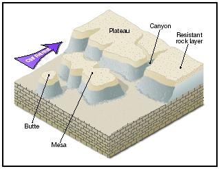
In laymen’s terms, a butte is a small flat-topped or pointed hill or mountain. A mesa is a medium size flat-topped hill or mountain. And a plateau is a really big flat-topped hill or mountain. However, the true definitions are elegant and fascinating and encompass some of the most amazing landscape in the Southwest. Buttes are geologic features up to hundreds of feet high with steep sides, narrow pointed tops or very small flat tops. Buttes are what is left of what was once a mesa; the rest of it has been eroded away. Paria Canyon contains the spectacular Coyote Buttes Special Management Area. The notorious sandstone buttes (North and South Coyote Buttes) sit at the bottom of Utah’s Grand Staircase-Escalante National Monument and the upper section of Arizona’s Paria Canyon-Vermillion Cliffs Wilderness. The buttes and surrounding canyons contain a unique feature called The Wave, a multi-colored chute that has been cut into a sandstone mountain.
A mesa started life as a flat plain or as part of a plateau. Rivers and streams have eroded away the surrounding area, leaving a flat-topped mountain. Typically, mesas have much larger tops that a butte, and many feel that a mesa can only be called that if standing water can sometimes be found. The Grand Mesa is an outstanding example of this kind of feature. The Colorado River shaped the canyons to the north of the mesa, while the Gunnison River shaped the south side, leaving a large flat-topped mesa in between. The surface area of Grand Mesa covers more than 500 square miles.
The definition difference between a butte and a mesa most likely originated right here in the Southwest. Early settlers said that if you could find game on top, it was a mesa. Eventually that definition translated to the idea that if you could graze cattle (and find water) it was a mesa, not a butte.
A plateau is an area of land that with a relatively level surface raised sharply above the adjacent terrain on at least one side and the surface area of the top of the mesa can be huge. For example, the Colorado Plateau covers portions of southeastern Utah, northern Arizona, northwestern New Mexico and western Colorado. It covers more than 130,000 square miles (only four states in the U.S. cover a larger area). When the rest of the western United States began to rise or uplift some 10 million years ago due to continental drift, the Colorado Plateau region remained stable – perhaps “floating” on a cushion of molten rock. Though ringed by volcanic features, very few volcanoes, managed to penetrate into the interior of the plateau.
Plateaus change there shape and size over time due mainly to erosion. There are three main types of soil erosion:
- Wind erosion: Wind erosion is the removal soil particles by the force and kinetic energy of the wind. These soil particles are transported and deposited when the wind energy drops.
- Gravity erosion: Mass movement of soil occurs on steep slopes under the influence of gravity. The process involves the transfer of slope-forming materials from higher to lower grounds due to self weight.
How to Claim this Earthcache:
In order to claim the find, send me an email using the link just belot the Earthcache title with the answers to the following questions:
Send me your answers BEFORE logging the find.
1) Are you standing on a plateau, a mesa or a butte?
2) What type of environmental factor shaped this elevated area?
3) If you look to the East/Southeast, the grounds seems to be at a __________ elevation than where you are standing.
4) If you look West, the ground seems to be at a __________ elevation than where you are standing.
5) (Optional) Post a picture of yourself and your GPS at the posted coordinates. This is not a requisite to claim the find, but a nice touch.
Send me the answers to these questions along with the GC code and the number of people in your party (with their geo nicknames) BEFORE you claim the find. I reserve the right to delete your log if you log the find first even if your answers are correct when I get them. I'm pretty lenient with every other requirement except this one.