BAYBURT KALESI
Bayburt Türkiye’nin kuzey doğusunda Çorun Nehri üzerine kurulmuş bir şehirdir. Bayburt, bir zamanlar eski İpek Yolu'nun önemli bir merkezi idi. Marco Polo ve Evliya Çelebi tarafından ziyaret edildi. Orta çağda yapılan kalenin kalıntıları hala bulunmaktadır. Kentte çeşitli tarihi camiler, Türk hamamları ve mezarlar var. Çatalçeşme Yeraltı Kompleksi gibi antik tarihi yerler ve ilin diğer bölgelerinde bulunan Şirakayalar Şelalesi gibi doğal güzellikler de vardır. Bayburt, Trabzon-Erzurum arasındaki güzergâh üzerinde açık ve verimli bir ovanın ortasında Çoruh’u ikiye bölüyor. Azzi halkı tarafından kurulan Bayburt daha sonra MÖ 8. yüzyılda Kimmerler, M.Ö. 7. yüzyılda Medler tarafından yerleşilmiş veya fethedilmiştir ondan sonra Persler, Pontus, Roma, Bizanslar, Bagratid Ermeni Krallığı, Selçuk Türkleri, Ak Koyunlular, Safevî Persler tarafından ve son olarak da Osmanlı Türkleri tarafından yerleşilmiş veya fethedilmiştir. Şehir 1.yüzyılda bir Ermeni kale yeri idi. Orta Çağ’ın sonlarında Cenevizlilerin bir kalesi olan Bayburt 13. yüzyılın sonlarında ve 14. yüzyılın başında Trabzon ve İran arasındaki ticaretten dolayı zenginleşmiştir. Selçuklu ve İlhanlıların zamanında şehirde bir darphane bulunmaktaydı. Bayburt, 1243'ten 1266'ya kadar kısa bir süre, Gürcistan prensi Samtskhe’nin kontrolü altındaydı. Bayburt kalesinde bir Hıristiyan kilisesi 13. yüzyılda Trapezuntine veya Gürcü etkisinde inşa edilmiştir. Osmanlı yönetimi altında şehir, Erzurum Eyaletine bağlı Bayburt Sancağının merkezi idi. Erzurum, 16. yüzyılın başlarında tahrip edildiğinde, Bayburt eyaletin fiili başkenti olarak bir süre görev yapmıştır. Bölgeye 1553'te Safeviler tarafından baskınlar düzenlendi. Bayburt, General Paskevich yönetimindeki bir Rus ordusu tarafından 1829'da ele geçirildi ve tahkimatı yıkıldı. Bu dönemde Rusların batıda ilerlediği en uç nokta Bayburt olmuştu. Birinci Dünya Savaşı'ndan önce şehirde bulunan 10.000 nüfus çoğunlukla bazı Ermenilerle birlikte Türk'tü.

Kale Dik Dağı'nın tepesinde, şehir merkezinin kuzey tarafındadır. Tam yapım tarihi bilinmemekle birlikte, MS 58'de inşa edildiği düşünülmektedir. 9., 10. ve 11. yüzyıllarda Bagratuni Hanedanlığı tarafından ele geçirilen kale 1200 ve 1230 yılları arasında, kalenin surlarındaki bir yazıt tarafından belirtildiği gibi, Saltuk hükümdarı Mugis-al-Din Tuğrul Sah tarafından tamamen yeniden inşa edilmiştir. Duvarlarının büyüklüğü ve taş duvarının kalitesi, Anadolu'daki tüm kaleler arasında en iyiler arasında yer alan kale, 19. yüzyılın başlarında Ruslar tarafından tahrip edilmiştir. Yeniden inşa Osmanlı döneminde yapıldı ve kalenin 1829 yılındaki yıkımına kadar yerleşim yeri olarak kullanıldı. Genellikle 5 veya 6 köşeli surlar yarı dairesel, kare veya üçgen şeklinde kulelerle desteklenmektedir. Kulelerin yüksekliği 12 veya 13 m ve surlar yaklaşık 30 m yüksekliğindedir. Doğu giriş kapısına "demir kapı", batı giriş kapısına "bekçi kapısı" adı verilir.
BAYBURT CASTLE
Bayburt is a city in northeast of Turkey lying on the Çoruh River and is the provincial capital of Bayburt Province. Bayburt was once an important center on the ancient Silk Road. It was visited by Marco Polo and Evliya Çelebi. Remains of its medieval castle still exist. There are several historical mosques, Turkish baths, and tombs in the city. There are also ancient historical sites such as the Çatalçeşme Underground Complex and natural wonders like the Sirakayalar Waterfall in the other parts of the province. Bayburt strattles the Çoruh amid an open and fertile plain on the route between Trabzon and Erzurum. It was founded by the Azzi people. It was subsequently settled or conquered by the Cimmerians in the 8th century BC, the Medes in the 7th century BC, then the Persians, Pontus, Rome, the Byzantines, the Bagratid Armenian Kingdom, the Seljuk Turks, the Aq Qoyunlu, Safavid Persia, and then the Ottoman Turks. The town was the site of an Armenian fortress in the 1st century and may have been the Baiberdon fortified by the emperor Justinian. It was a stronghold of the Genovese in the late Middle Ages and prospered in the late 13th and early 14th century because of the commerce between Trebizond and Persia. It contained a mint under the Seljuks and Ilkhanids. From 1243 to 1266, Bayburt was under brief control of the Georgian princes of Samtskhe. A Christian church within the Bayburt castle was built in the 13th century under the Trapezuntine or Georgian influence. Under Ottoman rule, the town was the center of the Bayburt Sanjak in Erzurum Eyalet. When Erzurum was devastated in the early 16th century, Bayburt served for a time as the de facto capital of the province. The area was raided by the Safavids in 1553. Bayburt was captured by a Russian army under General Paskevich and its fortifications thoroughly demolished in 1829. It was the furthest westward reach of the Russians during that campaign. Prior to the First World War, the population of 10,000 was mostly Turkish with some Armenians.
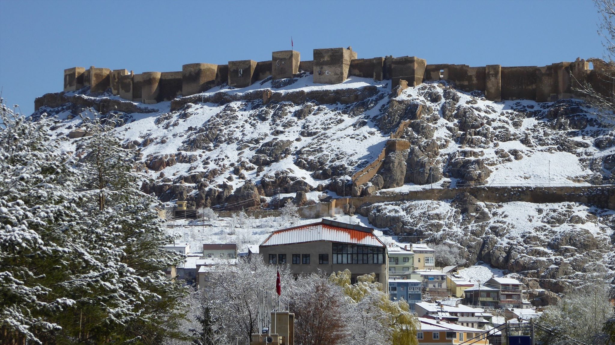
The castle is on the north side of the city center, on the top of the Steep Mountain. Although exact construction date is not known, it is believed to be built in 58 AD. It was held by the Bagratuni Dynasty in the 9th, 10th, and 11th centuries. It was completely rebuilt by the Saltuk ruler Mugis-al-Din Tugrul Sah between 1200 and 1230, as attested by an inscription in the walls of the castle. The massive size of its walls and the quality of its masonry place it amongst the finest of all the castles in Anatolia but it was destructed by the Russians during the early nineteenth century. Rebuilding was done during the Ottoman period. The castle was inhabited till the destruction of 1829. Ramparts usually with 5 or 6 corners are supported by semi-circle, square or triangle shaped towers. The heights of the towers are 12 or 13m and ramparts are about 30m high. The east entrance door is called “iron door” and the west entrance door is called “watchmen’s door”.