Weichsel-istiden
Det har funnits flera perioder under jordens historia då stora landmassor täckts av inlandsis, så kallade istider eller glacialer. Den senaste istiden, som lämnat många spår i det svenska landskapet, kallas Weichsel-istiden. Den hade sitt maximum för ungefär 20 000 år sedan, då sträckte sig ett kilometertjockt islager över hela Skandinavien ner till de norra delarna av Polen och Tyskland. Sedan blev klimatet varmare, och isen började smälta. Det tog det ungefär 10 000 år för isen att sakta smälta, och för knappt 10 000 år sedan var större delen av Sverige isfritt.
Isälvarna
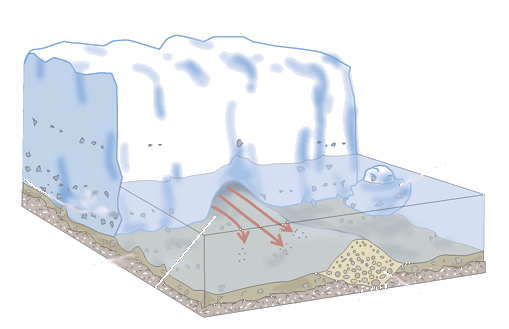
När inlandsisen smälte samlades smältvattnet till mycket strida isälvar som ledde ut till isfronten. Älvarna gick genom tunnlar och sprickor i isen, och följde ofta dalgångarna i berggrunden. Det strömmande vattnet i isälvarna tog med sig löst material, stenar, grus, sand med mera, när det forsade fram. Under transporten i isälven avrundades partiklarna när de nöttes mot varandra.
När vattnet närmade sig iskanten minskade strömhastigheten och därmed vattnets transportförmåga. Materialet sjönk till botten och avsattes som isälvssediment. Eftersom den smältande landisen gav upphov till mycket stora vattenmängder kan dessa isälvssediment vara mycket mäktiga.
Isälvssediment
Partiklar i jordarter indelas i storlek i diameter enligt följande:
- Block: mer än 200 mm
- Sten: 60 - 200 mm
- Grus: 2 - 60 mm
- Sand: 0,06 - 2 mm
- Silt: 0,002 - 0,06 mm
- Lera: mindre än 0,002 mm
Det vi kallar isälvssediment är isälvarnas grövre material från block ner till sand. Sand och grus är de vanligaste kornstorlekarna. Materialet är ofta sorterat, det vill säga partiklar av samma storlek har sedimentarat på samma plats, men såväl sorteringsgrad som kornstorlek kan växla avsevärt inom samma större avlagring.
De allra minsta partiklarna, leran, kunde följa med vattnet längre sträckor även när strömhastigheten minskade, och avsattes därför längre ut, oftast i havet.
När isälvssedimentet avsattes bildades åsar med branta sidor. De åsar som idag ligger ovanför högsta kustlinjen har behållit sina markerade krön och kallas därför getryggsåsar. De åsar som legat under högsta kustlinjen har däremot, under den period de befunnit sig i strandzonen, svallats av vågor och därmed fått en flackare och bredare form.
Bjästamon
Bjästamon är ett imponerande isälvssediment från en isälv som rann här för ungefär 10 000 år sedan. Inlandsisen över Västernorrland var mycket tjock, ca 3 km, och avsmältningen gick snabbt. Resultatet blev förstås enorma mängder smältvatten, och därmed mycket stora ansamlingar av isälvssediment där isälvarna drog fram. Ändå är det lätt att förbise bergen av isälvssediment, eftersom landskapet är så kuperat. Men de omgivande bergen är en del av bergrunden, till skillnad från Bjästamon. På kartan från SGU ser man hur Bjästamon avviker i sin uppbyggnad jämfört med de omgivande bergen. Bjästamons ungefärliga omfattning är markerad med gult, och Earthcachen är markerad med en symbol.
Earthcachen
För att undersöka Bjästamon besöker vi ett övergivet grustag i norra delen. Just eftersom man här har grävt sig in i sedimentet för att utvinna sand och grus, är det här en plats där vi kan få en uppfattning av hur stora mängder material som isälven transporterade hit, och också få en känsla av hur mäktig isälven måste ha varit. Vi kan också se hur sedimentet är sammansatt.
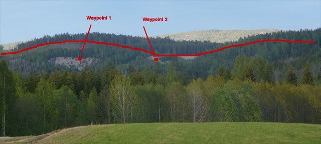
Gå till Waypoint 1, som även är själva Earthcachens koordinater. Följ gärna den sandiga väg som börjar vid Trail head. Ställ dig på kanten vid Waypoint 1 (utan att ramla ner). Börja med att beundra utsikten och föreställ dig den enorma älven som kommer strömmande rakt mot dig.
Frågor att besvara:
- 1. Titta på sedimentets sammansättning vid Waypoint 1 i rasbranten, från där du står och ca 2-3 m ner. Vilken/vilka av kornstorlekarna sand, grus, sten och block finns i sedimentet här? Vilken/vilka kornstorlekar dominerar?
- 2. Gå till Waypoint 2. Titta på sedimentets sammansättning i rasbranten, från där du står och ca 2-3 m ner. Vilken/vilka av kornstorlekarna sand, grus, sten och block finns i sedimentet här? Vilken/vilka kornstorlekar dominerar?
- 3. Jämför sedimentens sammansättning vid de två punkter du besökt. Hur skiljer de sig från varandra? Hur tror du denna skillnad kan ha uppkommit?
- 4. Vilken form har de stenar du hittar i sedimentet? Varför har de denna form?
- 5. Ligger Bjästamon över eller under högsta kustlinjen? Hur avspeglar sig detta faktum i mons form?
Efter att du har skickat svaren till mig via min profil, kan du logga cachen som hittad. OBS ATT SVAREN MÅSTE SKICKAS INNAN DU LOGGAR DEN SOM HITTAD. Tänk på att inte avslöja svaren i din logg. Bifoga gärna en bild av ditt besök, men tänk på att din bild inte ska avslöja svaren på frågorna.
Du kommer att få ett svar från mig inom en vecka. Loggar som görs innan man skickat in svar på frågorna kommer att raderas. Om ni är flera som löser uppgiften tillsammans kan ni skicka in ett gemensamt svar, men ange alla era geo-namn i mailet.
Ha ett trevligt besök i det gamla grustaget!
===============================================================
The Weichsel Ice Age
There have been several periods during the earth's history when large land masses were covered by inland ice, glaciers. The latest ice age, which left many trails in the Swedish landscape, is called the Weichsel Ice Age. It had its maximum about 20,000 years ago, then kilometer thick icebergs stretched across Scandinavia to the northern parts of Poland and Germany. Then the climate became warmer, and the ice began to melt. It took about 10,000 years for the ice to slowly melt, and almost 10,000 years ago, most of Sweden was ice-free
Glacial streams
When the ice melted, meltwater gathered into very fierce glacial streams that led to the ice front. The streams went through tunnels and cracks in the ice, and often followed the valleys in the bedrock. The flowing water brought loose material, stones, gravel, sand and more when it emerged. During transport in the stream, the particles were rounded when they bumped into each other.
When the water approached the ice edge, the flow rate and hence the transport capacity of the water decreased. The material dropped to the bottom and was deposited as glacial sediment. Because the melting ice gave rise to very large amounts of water, these sediments can be very large.
Glacial sediments
Particles in soils are divided into size in diameter as follows:
- Block: More than 200mm
- Stones: 60 - 200 mm
- Gravel: 2 - 60 mm
- Sand: 0.06 - 2 mm
- Silt: 0.002 - 0.06 mm
- Clay: less than 0.002 mm
What we call glacial sediment is the coarser material from the icebergs, from blocks down to sand. Sand and gravel are the most common grain sizes. The material is often sorted, that is, particles of the same size have sedimented in the same place, but both sorting and grain size can change significantly within the same major deposition.
The smallest particles, the clay, could be carried by the water longer ditances, even when the flow rate declined, and consequently was deposited further away, usually in the ocean.
When the ice-river sediment was deposited, ridges were formed with steep sides. The ridges that are currently above the highest coastline have retained their steeps. However, the ridges that lie below the highest coastline have, during the period they found themselves in the beach zone, swelled by waves and thus have a more varied and wider shape.
Bjästamon
Bjästamon is an impressive glacial sediment from a glacial straem that ran here about 10,000 years ago. The ice sheet over this part of Sweden was very thick, about 3 km, and the melting went fast. The result was, of course, huge amounts of melt water, and thus very large accumulations of glacial sediment. Nevertheless, it is easy to overlook the mountains of glacial sediment, as the landscape is so hilly. But the surrounding mountains are part of the bedrock, unlike Bjästamon. On map from SGU you can see how Bjästamon differs in its structure compared to the surrounding mountains. The approximate extent of Bjästamon is marked with yellow, and the Earthcache is marked with a symbol.
The Earthcache
To investigate Bjästamon you shall visit an abandoned gravel pit. This is a place where we can get an idea of the amount of material that the glacial stream transported here, and also get a sense of how powerful the stream must have been . We can also see how the sediment is composed.
Go to Waypoint 1 , which is the Earthcaches coordinates. Feel free to follow the sandy road beginning at Trail Head. Stand on the edge at Waypoint 1 (without falling down). Start by admiring the view and imagining the huge river that flows straight to you.
Questions to answer:
- Look at the composition of the sediment at Waypoint 1 , from where you stand and about 2-3 m down. Which of the grain sizes can you find here; sand, gravel, stone and block? What grain sizes dominates?
- Go to Waypoint 2 . Look at the composition of the sediment, from where you stand and about 2-3 m down. Which of the grain sizes can you find here; sand, gravel, stone and block? What grain sizes dominates?
- Compare the composition of the sediment to the two points you visited. How do they differ from each other? How do you think this difference may have occurred?
- What shape does the stones the sediment have? Why do they have this form?
- Is Bjästamon above or below the highest coastline? How does this fact reflect in the form of Bjästamon?
Once you've sent me the answers via my profile, you can log the cache as found. NOTE, ANSWERS MUST BE SENT BEFORE YOU LOG IT AS A FOUND. Remember to not reveal the answers in your log. If you want you can attach a photo of your visit, but keep in mind that your image will not reveal the answers to the questions.
You will receive a reply from me within a week. Logs made without submitting the answers to the questions will be deleted. If you are several cachers who solve the task together, you can submit one reply together, but write all your geonames in the mail.
Have a nice visit to Bjästamon!