Español
Localización
Al desfiladero de las xanas le llaman el pequeño Cares por su parecido a la popular garganta. Como aquella, tiene túneles, precipicios, un camino ganado a la roca a fuerza de pico y dinamita y paredes tan altas que uno corre el riesgo de hacerse daño en las cervicales si insiste en llegar hasta el final. Y como la Garganta Divina, también ésta tiene relación con lo sobrenatural. La xanas son pequeñas pero muy bellas. Llevan su melena larga y rubia atada con cintas de perlas o flores. También son extraordinariamente ricas, y esperan al pie de los caminos a que el viajero deshaga su madeja de hilo de oro para salir del encantamiento. Viven en las cuevas, las fuentes y en las orillas de los ríos, y de todo ello tiene la garganta abierta por el río Viescas. ¿Cómo puede extrañar que lleve el nombre de las hadas asturianas?
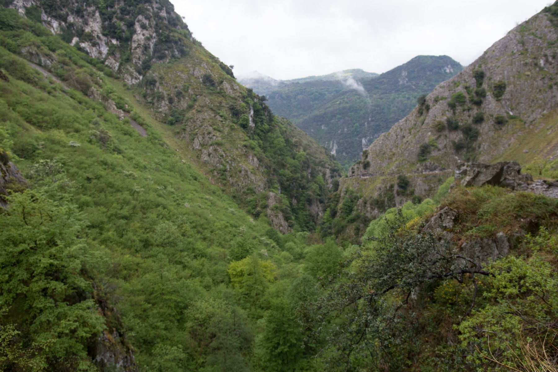
El desfiladero de las Xanas se encuentra entre los concejos asturianos de Santo Adriano, Quirós y Proaza. Tiene una longitud de alrededor de dos kilómetros y llega a alcanzar una altura de 500 metros entre el fondo del barranco y las cumbres de las montañas que le rodean. Su belleza y su interés geológico le hizo acreedor del título de Patrimonio Natural en 2002. Se puede visitar gracias a un camino excavado en la roca, herencia de un proyecto de los años cincuenta del pasado siglo cuyo objetivo era unir Pedroveya, Rebollada y Dosango con el valle del Trubia. Sus valores geológicos y geomorfológicos le han merecido la consideración de Punto de Interés Geológico
Geológicamente el Desfiladero de Las Xanas (Sierra de Serandi) se ubica en la Zona Cantábrica y dentro de las unidades en que se subdivide esta Zona, en la Unidad del Aramo, tal como se puede apreciar en la siguiente figura, donde se ha señalado con un circulo rojo la situación del Desfiladero
Geomorfologia
Origen
Salvo los depósitos más recientes del Cuaternario, todas las rocas pertenecen al Palezoico y tienen naturaleza variada, habiendo pizarras, areniscas, dolomías, calizas y margas, siendo las predominantes las calizas. El propio desfiladero esta formado por Calizas de Montaña, apareciendo calizas blancas (Calizas de Candamo) y caliza rosada (Griotte), en las que se pueden ver fósiles como Goniatites y tallos de Poteriocrinus. Estas rocas se originaron bajo el mar, en aguas de poca profundidad, y fueron elevadas y deformadas hace unos 300 millones de años, siendo el resultado un serie de pliegues apretados, con flancos muy verticales y ocasionalmente cortados por fallas
Formación
Un desfiladero es una abertura estrecha y alargada como una garganta que se encuentra entre montañas y que en algún tiempo remoto fue el cauce de aguas fluviales, también recibe el nombre de paso de montaña, garganta, puerto, paso, hoces o abras, según las dimensiones que lo caractericen en determinada región
La erosión fluvial como factor determinante
El agua de los continentes suele discurrir con frecuencia tal como lo hacen los ríos sobre la superficie de la tierra, o bien en forma de corrientes subterráneas (o freáticas) produciendo una continua fricción contra los materiales sedimentarios y erosionándolos. A su vez, mientras el agua sigue corriendo arrastra con todos los residuos resultantes, los transporta en dirección a las zonas más bajas del relieve y los deposita en distintos espacios. De esta manera se conforman plataformas sedimentarias como terrazas fluviales, conos de deyección y demás accidentes geográficos. Simultáneamente, el agua que discurre en las corrientes fluviales genera cascadas, grutas, meandros, deltas, estuarios, etcétera. Todos estos procesos en su conjunto terminan configurando paisajes y abasteciendo el medio ambiente de una belleza superior.
Disolver es más fácil que arrastrar, mecanismo de disolución:
El ácido carbónico que causa estas formaciones se forma cuando la lluvia pasa a través de la atmósfera y recoge el dióxido de carbono (CO2), que se disuelve en el agua. Una vez que la lluvia llega al suelo, puede pasar a través del suelo y proporciona mucho más CO2 para formar una solución de ácido carbónico débil, que disuelve el carbonato de calcio de la roca
Para logar este EarthCache, envíame un correo electrónico con la respuesta a las siguientes preguntas:
1) ¿Cual es el factor determinante en la formación de un desfiladero? ¿Que gas participa en la disulución de la caliza?
2) ¿En que zon geologica se encuentra el desfiladero?
3) En las coordenadas dadas, del aldo del desfiladero hay una roca. Dime sus dimensiones aproximadas y su forma
-Si crees que as concluido con exito los objetivos de este Earth Cache, y me ha enviado todas las respuestas solicitadas, puede hacer el log. Luego yo comprobaré que son correctas, y si hay cualquier problema me pondre en contacto para arreglarlo.
-Logs sin respuestas enviadas previamente, seran borrados sin aviso
-Las fotografias son opcionales, pero se agradecen y ayudan a verificar la visita
English
(Google translate)
Location
The gorge of Las Xanas it´s called the little Cares by its resemblance to the popular throat. Like that, it has tunnels, cliffs, a path gained to the rock by force of peak and dynamite and walls so high that one runs the risk of being hurt in the cervicals if insists in arriving until the end. And like the Divine Throat, it also has a relation to the supernatural. The shakes are small but very beautiful. They wear their long, blond hair tied with strings of pearls or flowers. They are also extraordinarily wealthy, and wait at the foot of the roads for the traveler to undo his skein of gold thread to escape the enchantment. They live in the caves, the fountains and the banks of the rivers, and all of this has a throat open by the river Viescas. How strange can it be that it bears the name of the Asturian fairies?
Geomorphology
Origin
Except for the most recent deposits of the Quaternary, all the rocks belong to the Paleozoic and have a varied nature, having slates, sandstones, dolomites, limestones and marls, being the predominant limestone. The gorge itself is formed by Mountain Limestone, with white limestone (Candamo Limestone) and pink limestone (Griotte), where you can see fossils such as Goniatites and Poteriocrinus stems. These rocks originated under the sea, in shallow waters, and were raised and deformed about 300 million years ago, resulting in a series of tight folds, with very vertical flanks and occasionally cut by faults
Formación
A gorge is a narrow, elongated opening like a gorge between the mountains and at some remote time was the channel of water, is also called mountain pass, throat, port, step, sickle or open, according to dimensions that characterize it in a given region
River erosion as a determinant factor
The water of the continents often runs as rivers do on the surface of the earth, or in the form of underground currents (or groundwater) producing a continuous friction against sedimentary materials and eroding them. In turn, while the water continues to run, it drags with all the resulting residues, transports them towards the lower areas of the relief and deposits them in different spaces. In this way, sedimentary platforms such as river terraces, dew point cones and other geographical features are formed. Simultaneously, the water that flows in the fluvial streams generates waterfalls, caves, meanders, deltas, estuaries, and so on. All these processes as a whole end up configuring landscapes and supplying the environment of a superior beauty.
Dissolving is easier than dragging, dissolution mechanism:
The carbonic acid that causes these formations is formed when rain passes through the atmosphere and collects carbon dioxide (CO2), which dissolves in water. Once the rain reaches the ground, it can pass through the soil and provides much more CO2 to form a weak carbonic acid solution, which dissolves the calcium carbonate from the rock
To log this earthcache, send me an email with the answer to the following questions:
1) What is the determining factor in the formation of a gorge? What gas is involved in the limestone´s dissolution?
2) In what geological zone is the gorge?
3) At the given coordinates, from the side of the gorge is a rock. Tell me its approximate dimensions and shape
-If you believe you have successfully completed this Earth Cache goals and has already sent to me all the requirements as requested, Please, feel free to log it as found. Later i will verify the requirements sent and, if necessary, contact you in order to make the necessary corrections to your log.
-Logs without answers, will be deleted without notice.
-Pictures are optional, but they are welcome and will be usefull to verify you visit