La Earthcache / The Earthcache
Une petite île à l'une des extrémités du continent eurasiatique, l'île d'Ouessant (Enez Eussa), dresse ses falaises à une vingtaine de kilomètres de la côte occidentale du pays de Léon: elle marque l'ultime avancée, dans l'Atlantique, du socle armoricain émergé.
Elle est la terre la plus occidentale de la France métropolitaine et l'un des promontoires ruiniformes de l'immense continent eurasiatique.
► Contexte géologique général
L'existence même de cette île, surgissant d'une centaine de mètres à l'entrée de la Manche, semble en relation avec le rejeu de failles transversales.
Ces mouvements tectoniques puissants sont à l'origine de plusieurs structures faillées amenant en contact anormal différents types de roches, principalement de nature granitique (granite à deux micas de Lokeltas, granite porphyroïde rose,...), surtout dans la partie septentrionale, avec une dépression médiane creusée dans des roches métamorphiques (micaschistes...), mais également des formations intrusives originales comme la trondhjémite ou de la pegmatite.
Cette petite série de EarthCaches va nous permettre de faire un rapide aperçu de cette diversité géologique de l'île.
Ce quatrième opus est l'occasion de découvrir quelles roches constituent la pointe du Pern, l'extrémité ouest de notre territoire métropolitain, qu'on peut aussi qualifier de bout du monde (Pen Ar Bed).

► La roche du bout du monde
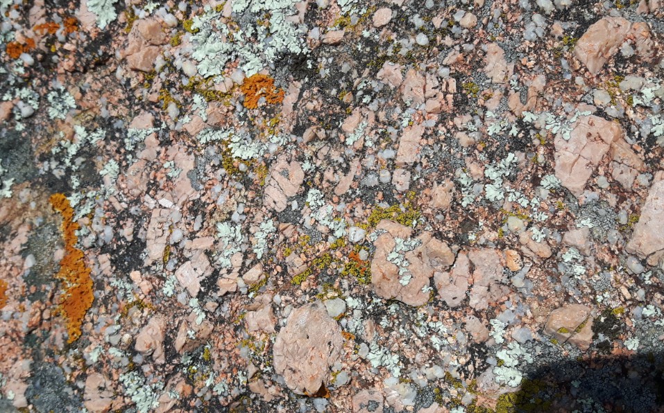
L'observation de la carte BRGM nous donne comme formation de la partie la plus septentrionale le leucogranite de Lokeltas.
Ce granite à deux micas constitue l'ossature septentrionale de l'île d'Ouessant, de la pointe de Pern à l'Ouest à la pointe de Bac'haol à l'Est, sur plus de 8 km de long. Ce massif allongé va en s'élargissant progressivement d'Est (0,6 km) en Ouest (au moins 1,6 km).
C'est généralement une roche assez grossière, leucocrate, avec feldspath potassique, plagioclase acide, quartz, biotite et muscovite.
Par certains endroits, le granite peut avoir un orientation des minéraux, mais dans les falaises de la baie de Lampaul et vers la pointe du Pern, le granite n'offre plus aucune orientation. On parle alors de roche anatectique.
Il s’agit d’une roche grenue (taille de grain de 3 à 5 mm) qui constitue un terme de transition entre le pôle dioritique et le pôle évolué à biotite dominante.
La composition minéralogique associe un plagioclase dominant, du quartz (plutôt translucide), du feldspath potassique (de couleur rose), de la hornblende verte et de la biotite (de couleur noire).
Cette roche est une roche magmatique. mais d'ou vient t-elle ?
► Qu'est-ce qu'une roche magmatique ?
Les magmas existent tous dans le manteau, sous l'écorce terrestre. Les roches magmatiques sont issues de la cristallisation de ces magmas.
Il existent deux familles de roches magmatiques, qui vont dépendre de la façon et de l'endroit ou elles se sont cristallisées :

- Les roches volcaniques, ou roches extrusives.
Elles sont issues d'un magma qui s'introduit dans la croûte terrestre puis se fraie un chemin jusqu'à la surface et donner lieu à des coulées de laves qui, en cristallisant, forment des corps extrusifs : volcans sous-marins ou volcans continentaux.
Du fait de cette remontée, la cristallisation est très rapide, ce qui produit de très petits cristaux; la roche résultante sera une roche à fins cristaux qu'on ne distingue généralement pas à l'oeil nu, même à l'aide d'une loupe.

- Les roches plutoniques, ou roches intrusives.
Elles sont issues d'un magma qui est resté coincé dans la croûte et y cristalliser pour former des corps intrusifs.
Lorsque le magma cristallise à l'intérieur de la croûte terrestre, l'abaissement de sa température est lent et plus la cristallisation sera lente, plus les cristaux seront gros, généralement bien visibles.

On a donc deux grands groupes de roches ignées: les roches ignées extrusives, à très fins cristaux, et les roches ignées intrusives, à cristaux grossiers.
A cette taille de cristaux, la composition des différents minéraux va également conditionner la nature de la roche magmatique.

Pour chaque composition minérale, il existera une version extrusive et une version intrusive.
En effet, la différence entre basalte et gabbro, andésite et diorite, rhyolite et granite, ne se situe pas au niveau de la composition qui est la même pour chacune des paires, mais au niveau de la cristallinité, soit la taille des cristaux.
A small island at one end of the Eurasian continent, the island of Ouessant (Enez Eussa), draws its cliffs about twenty kilometers from the western coast of the country of Leon: it marks the ultimate The Atlantic, the Armorican basement emerged.
It is the most western land of metropolitan France and one of the ruiniform promontories of the immense Eurasian continent.
► Local Geological Context
The very existence of this island, emerging from a hundred meters at the entrance of the Channel, seems in relation to the replay of transverse faults.
These powerful tectonic movements are at the origin of several faulty structures bringing into contact abnormal different types of rocks, mainly of granite nature (granite with two micas of Lokeltas, pink porphyroïde granite, ...), especially in the northern part, with A median depression excavated in metamorphic rocks (micaschistes ...), but also original intrusive formations such as trondhjemite or pegmatite.
This small series of EarthCaches will allow us to give a quick overview of this geological diversity of the island.
This fourth opus is the opportunity to discover which rocks constitute the Pern tip, the western end of our metropolitan territory, which can also be described as the end of the world (Pen Ar Bed).

► Rock at the End of the World
The observation of the BRGM map gives us as the formation of the most northern part the leukogranite of Lokeltas.
This two-micas granite constitutes the northern skeleton of the island of Ouessant, from the point of Pern to the west at the point of Bac'haol in the East, over 8 km long. This elongated massif is gradually widening from East (0.6 km) to West (at least 1.6 km).
It is generally a rather coarse rock, leucocrat, with potassic feldspar, acid plagioclase, quartz, biotite and muscovite.
In some places, the granite may have a mineral orientation, but in the cliffs of Lampaul Bay and towards Pern Point, the granite no longer offers any orientation. This is called an anatectic rock.
It is a grainy rock (grain size 3 to 5 mm) which constitutes a transitional term between the dioritic pole and the dominant biotite pole dominant.
The mineralogical composition associates a dominant plagioclase, quartz (rather translucent), potassic feldspar (pink), green hornblende and biotite (black).
This rock is a magmatic rock. But where does it come from?
► What is a magmatic rock?
Magmas all exist in the mantle, under the earth's crust. The magmatic rocks are the result of the crystallization of these magmas.
There are two families of magmatic rocks, which will depend on the way and the place where they crystallized:

- Volcanic rocks, or extrusive rocks.
They are derived from a magma which penetrates into the earth's crust and then clears its way to the surface and gives rise to lava flows which, by crystallizing, form extrusive bodies: submarine volcanoes or continental volcanoes.
Because of this rise, the crystallization is very rapid, which produces very small crystals; The resulting rock will be a rock with fine crystals that can not be distinguished with the naked eye, even with a magnifying glass.

- Plutonic rocks, or intrusive rocks.
They are derived from a magma that has remained stuck in the crust and crystallized to form intrusive bodies.
When the magma crystallizes inside the earth's crust, the lowering of its temperature is slow and the crystallization will be slow, the crystals will be large, generally well visible.

There are thus two large groups of igneous rocks: extrusive igneous rocks, very fine crystals, and intrusive igneous rocks with coarse crystals.
At this size of crystals, the composition of the various minerals will also condition the nature of the magmatic rock.

For each mineral composition, there will be an extrusive version and an intrusive version.
Indeed, the difference between basalt and gabbro, andesite and diorite, rhyolite and granite, is not at the level of the composition which is the same for each of the pairs, but at the level of the crystallinity, that is to say the size of the crystals.
► Sources bibliographiques / Bibliographical sources
Les Questions / The Questions
La lecture attentive du descriptif de la cache, ainsi qu'une observation des éléments de terrain et un peu de déduction sont normalement suffisants pour répondre aux questions de cette EarthCache.
A careful reading of the description of the cache, as well as observation of terrain features and some deduction is usually sufficient to answer questions of this EarthCache.
Questions pour valider :"Quelle roche en Pen Ar Bed ?"
Questions to validate: "Which rock in Penn Ar Bed?"
Point 1 : N 48° 26.942 W 005° 08.446
Vous voici devant un énorme bloc de roche de plusieurs mètres de hauteur. Observons sa partie droite (partie droite photo WP1_2)
Here you are before a huge block of rock several meters high. Observe its right part (right part photo WP1_2)

- Question 1 : Décrivez la roche. Est-ce une roche intrusive ou extrusive (justifier votre réponse).
- Question 1 : Describe the rock. Is an intrusive or extrusive rock (justify your answer).
- Question 2 : La roche est-elle orientée ? En fonction de votre réponse, comment pourriez-vous la qualifier ?
- Question 2 : Is the rock oriented? Based on your answer, how would you qualify it?
- Question 3 : Ci dessous voici une photo de granite de la pointe d'Omigna, une formation magmatique corse. D'après vous, quelle roche s'est cristallisée le plus vite ? Justifier votre réponse.
- Question 3 : Here below is a photo of granite of the point of Omigna, a Corsican magmatic formation. In your opinion, which rock crystallized the fastest? Justify your answer.
Point 2 : N 48° 26.932 W 005° 08.440
Dirigez-vous maintenant vers le côté gauche de cette barre rocheuse (partie gauche photo WP1_2 du dessus) et chercher la photo WP2.
Now go to the left side of this rocky bar (left photo WP1_2 above) and look for photo WP2.
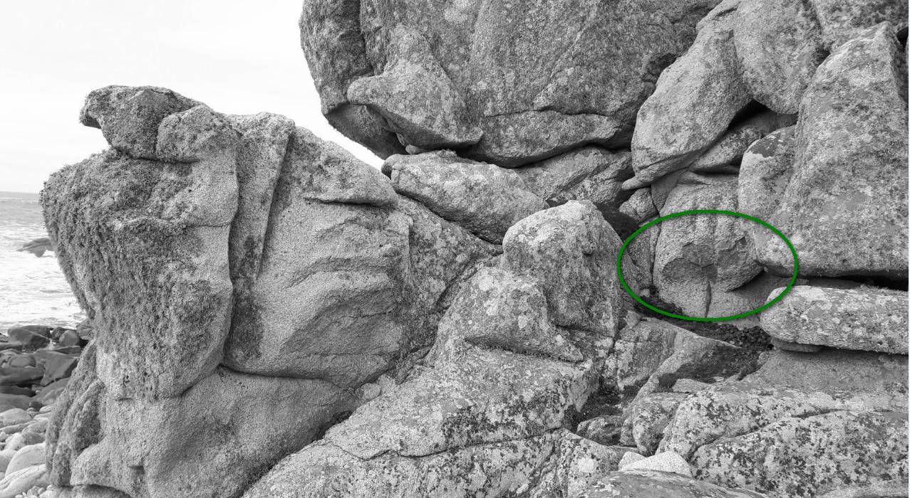
- Question 4 : Quelle est la couleur de la roche dans le cercle vert. A quoi est due cette coloration ?
- Question 4 : What is the color of the rock in the green circle. What is the cause of this coloration?
Point 3 : N 48° 26.923 W 005° 08.398
Vous voici devant un panneau explicatif.
Here you are before an explanatory panel.
- Question 5 : A quelle construction est-elle dédiée ? Dans quel but a t-elle été construite ?
- Question 5 : What construction is it dedicated to? For what purpose was it built?
Vous pouvez vous loguer sans attendre notre confirmation,
mais vous devez nous envoyer les réponses en même temps soit par mail via notre profil (
fafahakkai), soit via la messagerie geocaching.com (Message Center).
S'il y a des problèmes avec vos réponses nous vous en ferons part.
Les logs enregistrés sans réponses seront supprimés.Une photo de vous ou de votre GPS avec la mer en arrière plan serait la bienvenue, mais n'est pas obligatoire.
You can log this cache without waiting for our confirmation, but you must send us the answers at the same time, by e-mail via our profile (fafahakkai) or by the system of Message Center of geocaching.com.
If there is a problem with your answers we will notify you. The logs recorded without answers will be deleted.
A photo of you or your GPS with the sea in the background would be welcome but is not mandatory.
Rappel concernant les « Earthcaches »: Il n'y a pas de conteneur à rechercher ni de logbook à renseigner. Il suffit de se rendre sur les lieux, de répondre aux questions ci-dessus et de nous renvoyer les réponses.
Reminder concerning "Earthcaches": there is neither a container to look for nor a logbook to sign. One need only go to the location, answer to the differents questions and send us the answers.