Aéroport de Nantes Atlantique - Vue sur la piste Traditional Geocache
Aéroport de Nantes Atlantique - Vue sur la piste
-
Difficulty:
-

-
Terrain:
-

Size:  (small)
Please note Use of geocaching.com services is subject to the terms and conditions
in our disclaimer.
[FR]
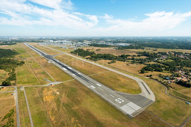
L'aéroport de Nantes Atlantique, auparavant dénommé Aéroport International Château Bougon (code AITA : NTE • code OACI : LFRS), est un aéroport international français mono piste situé sur le territoire des communes de Bouguenais et de Saint-Aignan-Grandlieu, au sud-ouest de Nantes.
En 1928, un camp d'aviation fut créé pour un usage essentiellement militaire, sur un terrain de 50 hectares au bord de la N23 de Nantes à Paimbœuf (actuelle RD 723), près du Château de Bougon (ancienne châtellenie du ixe siècle à l'origine du village de Bouguenais et dont le nom porte celui du « ruisseau de Bougon » qui coule à proximité). Aménagé à partir de 1932, il accueillit en 1934-1935 au Brossais une usine des établissements Breguet, avec un raccordement au terrain d'aviation.
En 1939, la piste en herbe est remplacé par une piste bétonnée de 900 m × 40 m.
Pendant l'occupation, les Allemands en firent un véritable camp avec baraquements, blockhaus, casemates en béton. De là partaient les bombardiers de la Luftwaffe vers l'Angleterre. Les Alliés, mesurant l'importance stratégique du site, avec l'usine d'aviation à proximité, bombardèrent le terrain le 4 juillet 1943. Il y eut 20 victimes civiles, et l'usine fut aux trois quarts détruite et rendue inutilisable.
À la fin de guerre, l'Armée de l'air française reprit possession du terrain, dont les Allemands avaient détruit les infrastructures au moment de leur retraite. En 1948-49, le terrain porta sa superficie à environ 300 hectares. Les premières activités commerciales de l'aérodrome apparurent en 1951, avec la construction de premier bâtiment (en bois), alors que se développaient les activités de tourisme et de vols d'essais.
La voie ferrée Nantes - Sainte-Pazanne (allant jusqu'à Saint-Gilles-Croix-de-Vie et Pornic) est déviée en 1967 sur une longueur 4 500 mètres. Durant les années 1970, la longueur de la piste est portée à 2 300 mètres, tandis qu'une nouvelle salle d'embarquement et une aérogare de fret sont construits, et un parking payant pour automobiles est aménagé.
Dans les années 1980, la capacité d'accueil de l'aéroport est augmenté de 50 % : sa surface passe à 8 300 m2 pour l’aérogare passagers et 2 400 m2 pour l’aérogare de fret6. Il accueille son millionième passagers en 1988 et prend alors son nom actuel6. Une nouvelle tour de contrôle est érigée durant les années 1990, tandis que la surface de l'aérogare double et passe à 27 000 m2.
Aujourd'hui la piste en béton bitumineux mesure 2 900 m (9 514 ft) et est orientée dans la direction 03/21
_________________________________________________________________________________________________________________________________
[EN]
The airport of Nantes Atlantique, formerly known as International Airport Chateau Bougon (AITA code: NTE), is a French international single-track airport located in the communes of Bouguenais and Saint-Aignan-Grandlieu, in the south West of Nantes.
In 1928, an aviation camp was created for mainly military use on a 50-hectare site along the N23 from Nantes to Paimbœuf (now RD 723), near the Château de Bougon (formerly the ninth-century châtellenie The origin of the village of Bouguenais and whose name bears that of the "stream of Bougon" which flows nearby). Built in 1932, in 1934-1935, he welcomed a factory in the Breguet factory, with a connection to the airfield.
In 1939, the grass track was replaced by a concrete track of 900 m × 40 m.
During the occupation, the Germans made it a real camp with barracks, blockhouses, concrete casemates. From there the bombers of the Luftwaffe left for England. The Allies, measuring the strategic importance of the site, with the nearby aviation factory, bombed the ground on July 4, 1943. There were 20 civilian casualties, and the factory was destroyed three quarters and made unusable.
At the end of the war, the French Air Force took possession of the land, which the Germans had destroyed the infrastructure at the time of their retirement. In 1948-49, the land expanded to about 300 hectares. The first commercial activities of the aerodrome appeared in 1951, with the construction of the first (wooden) building, as tourism and test flights developed.
The Nantes-Sainte-Pazanne railway (up to Saint-Gilles-Croix-de-Vie and Pornic) diverted in 1967 over a length of 4,500 meters. During the 1970s, the length of the runway was increased to 2,300 meters, while a new boarding lounge and freight terminal were built, and a paying car park was set up.
In the 1980s, the capacity of the airport was increased by 50%: its surface area increased to 8,300 m2 for the passenger terminal and 2,400 m2 for the freight terminal6. It hosts its millionth passenger in 1988 and then takes its current name6. A new control tower was erected during the 1990s, while the surface of the terminal doubled to 27,000 m2.
Today, the bituminous concrete track is 2,900 m (9,514 ft) and is oriented in direction 03/21

Additional Hints
(Decrypt)
[FR] Ha tenaq pynffvdhr dhv pbyyr ;)
[EN] N pynffvp gung fgvpxf ;)