Outer Drive: It starts and stops again, it runs north, south, east, and west. It twists in long curves and has some fairly-long straight-aways. If it was a racetrack, it would be one of the most interesting ones on any racing circuit.
It is, for the most part, a "ring" around the City of Detroit and encompasses mostly Detroit-proper, but does also include some of the western and southwestern Suburbs of the Metro Area. If you travel the entire length, you will encounter residential, commercial, and industrial areas, sometimes all within a few blocks of one another.
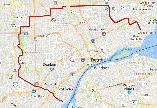
To some folks, it seems almost "bizarre" in its horseshoe-shaped design. It runs for more than 40 miles in a "jagged pattern" from Ecorse, MI at Jefferson Avenue downriver up to the north end along Livernois, moving across east to west within a mile of the 8-mile-road border between Detroit and its northern Suburbs, then back down again to the far east side near the border of Detroit and Grosse Pointe.
The origins of this odd and mysterious winding road can be found in the Burton Collection at the Detroit Public Library, and provide an insight into what has to be one of the most unusual city thoroughfares in the country.
In a Detroit News article, written in 1922:
“With its end at the extreme east and west sides of Detroit, its route clustered with beautiful subdivisions, potential residence districts, school sites, park areas and parkways, an Outer Drive, still unnamed, is fast emerging from its state as the dream of a former Detroit mayor into a reality.
“The history of the Outer Drive is brief. A committee was appointed by Mayor Oscar B. Marx, in February, 1918, to study the advisability of such a highway. Members of the committee had no sooner investigated the project than they became interested. Interest led to something akin to enthusiasm when a comprehensive report was filed recommending ‘a boulevard 150 feet wide to encircle the city eight miles from its center on the east and north, connecting with Oakman Highway on the west.’”
A 1929 article in Michigan Women magazine predicts a “great pleasure boulevard” that will “lie like a necklace around Detroit …”
“It was laid out as a grandiose parkway,” explains one architect. “It was not intended to move traffic efficiently from Point A to Point B. It was intended to be a picturesque drive.”
The concept, so its believed, can be traced to the 1892 World’s Columbian Exposition in Chicago, where an urban planning model dubbed “City Beautiful” was unveiled. Conceived in reaction to the industrial age, the model provided city planners with strategies to reclaim urban areas from factories and skyscrapers by envisioning development on a more human scale.
“It was a broad, sweeping philosophy,” as it was explained, saying the intent was to create “the ultimate city for the working man.”
It was noted that the problem with Outer Drive is that it was built in pieces, rather than planned and built all-at-once. To expedite construction of Outer Drive, it was linked to many of the existing roads whenever possible. Some of these well-known streets include: Whittier, Chandler Park Drive (which is similar in the boulevard-design of Outer Drive), Conner, State Fair Ave., Vassar Dr., Lahser, Military, as well as many other lesser-traveled streets. This "expedition of construction" may explain why it suddenly becomes "another street" almost without warning, and yet still has the appearance of continuing along the path it had traveled.
Between Woodward and Livernois, near the "upscale" Palmer Woods subdivision north of 7 mile road, neighborhood associations in the 1920s successfully blocked the construction of Outer Drive. They claimed the increased traffic would hurt property values and increase noise pollution in their serene and quiet neighborhoods.
Although much of Outer Drive has what some residential architects call a “signature” look characterized by individually designed, expertly crafted brick Tudors and colonials, with bungalows and more modern designs mixed in, the look is not consistent throughout because construction came subdivision by subdivision. “You move through the city, the status of different neighborhoods kind of changes.”
These days, that status ranges from some of southeast Michigan’s most affluent addresses to blighted areas with dilapidated rental properties and even many areas beyond Outer Drive itself, with a few blocks of empty space that once held family homes.
But for the most part, Outer Drive has managed to escape the flight to suburbia that has devastated other parts of Detroit. It’s maintained its reputation as a status address.
It is said that "Outer Drive, is a fairly good remnant of City Beautiful thinking. And, mostly, it works.”
With this....we present to you the
v2.0 of the Outer Drive Series.
Interesting information about the first ODS series:
It took approximately 8 weeks of placing, planning, and publishing to create the initial 198 caches (197 traditionals plus one SQ-Final) and was placed from December 2011 through January 2012. As other caches that had been along the route were archived, "fill-ins" were placed to have a total of 209 caches in the series. If it had been logistically possible to place a cache every 528' and keep it in-place, the series could have totalled an estimated over 400-plus geocaches.
The first series began publishing on Feb 14, 2012 at approximately 5.00pm Eastern Time, with one of the first found logs about 5.16pm. The publishing ended approximately 90 minutes later. There were some folks that were out finding the caches in the series until at least 6.00am the following day in the almost-32°F weather.
Some folks had completed the entire first series in one day from 9 to 11 hours total time.
During the 5+ year run for the original series, there were several hundred cachers who had found at least parts of it, with approximately 100 who had completed the entire series (except the SQ-final which saw less than 50 finders).
The final "found it" log was on March 16, 2017 while in the process of placing the new series.
Please note the following:
* This series is mostly urban-type hides and is best done in teams of two or more cachers. It is very repetative at times, but you will see many things that make Detroit (and suburbs) interesting.
* IF you leave your vehicle unattended for any reason, PLEASE MAKE SURE YOU LOCK IT and DO NOT leave any valuables "out in the open". Just as you would on any other PUBLIC street, there may be any number of people around any time of the day or night.
* You will encounter muggles of all types, shapes, and sizes. If you do not feel comfortable in this type of environment, then please follow the rule of "be aware of your surroundings" and take a friend with you to assist and/or provide security.
* You may need any number of your "normal geocaching tools" including a grabber or retrieval tool, a stool or small ladder (some folks who are vertically-challenged will need these), bug-spray, flashlight (night), and even a first-aid kit should you injure yourself somewow. You may need anything else that you would normally carry with you, that may come in handy while caching.
* You need to sign the log (per Geocaching/Groundspeak rules) with a PEN or other writing instrument (none are included, sorry).
* This series is supposed to be easy for *most* Geocachers, new or experienced, and provide a nice tour around Detroit.
* The coordinates have been checked to ensure that they are within 20' accuracy of actual location, but if you feel a correction is needed, please let us know and we will check it out.
* Most of the cache containers are in "typical" hiding spots, with a few of them a bit more of a challenge.
* There are SIX (6) containers along the *entire* stretch of the series, that have "pieces to the puzzle" for a final, located in a Cemetery that has limited daytime hours. The puzzle pieces *will* be obvious and different than the logs themselves. Please do not remove these pieces from the caches, but note the information elsewhere for the puzzle final. Please do NOT add this information to your online log.
Maintainence-related notes:
* If you find an ODS cache with a container-issue, or has a full, damaged, or missing log, you may add a piece of paper to the cache and *please* note in your log that this was done.
Yes, we DO read all the logs.
If nothing else, please log a "Needs Maintenance" to make the team aware that we need to address whatever issue is there, just as you would with any other Geocache.
MOST OF ALL.... HAVE FUN AND ENJOY THE CACHES.