LA SOURCE DE PANNECUL
Le Pannecul ou ruisseau de la Fontaine Noire est un ruisseau français du département de la Côte-d'Or dans la région Bourgogne-Franche-Comté et un affluent droit de la Bèze, donc un sous-affluent du Rhône par la Saône.
Il traverse trois communes et un seul canton dans le sens amont vers aval : Viévigne (source), Bèze, Noiron-sur-Bèze (confluence).
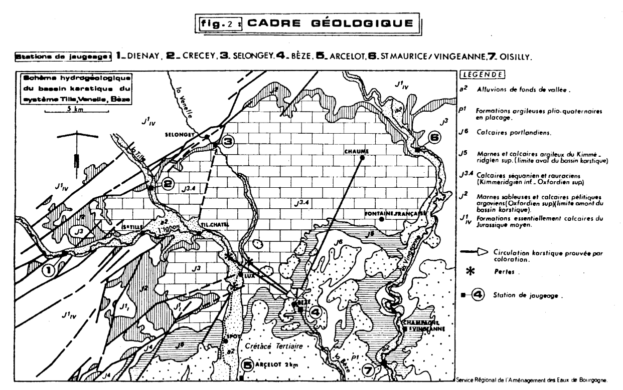
La géologie du plan d'eau du Pannecul est constituée de formations calcaires de l’ère secondaire. Le centre-ouest du bassin (de Noiron-sur-Bèze jusqu’à la source de l’Albane), est constitué de formations secondaires du Crétacé et de formations tertiaires anté-Pliocène. Cette série du Crétacé bien complète forme un monoclinal à léger plongement Sud-ouest où la craie cénomano-turonienne forme une côte au-dessus des argiles de l’Albien. Elle donne des collines arrondies typiques. L’amont du bassin de la Bèze est alimenté par un important réseau karstique issu en partie des pertes de la Tille et de la Venelle. Une partie des eaux de pluie vient alimenter ces nappes. La source de la Bèze est l’exutoire de cet important réseau
Il est l'un des principaux affluents de la Bèze, et le second à s'y jeter, avec : l’Albane (17 km) et le Chiron (8 km). Plusieurs études ont montré que le bassin versant topographique situé sur la commune de Bèze, qui est seulement de 32,6 km2, serait au centre d'un réseau hydrologique plus vaste, entre 225 et 890 km2, vraisemblablement de 400 km
Source
| :https://fr.wikipedia.org/wiki/Pannecul |
Rappel concernant les « Earthcaches »: Il n'y a pas de conteneur à rechercher ni de logbook à renseigner. Il suffit de se rendre sur les lieux et de répondre aux questions posées.
Loguez cette cache "Found it" et envoyez-moi vos réponses soit via mon profil, soit via la messagerie, je vous contacterai en cas de problème.
Une photo (optionnelle) de votre visite serait un plus
Question n°1:
De quelle fomation est constituée la source de Pannecul? Quel âge a cette formation? (une fourchette en millions d'années)
Question n°2:
Aux abords de la source, le long du mur,( WP2 MUR) vous pouvez trouver des affleurements de pierre typique. De quelle periode sont ils ? Quels fossiles pouvez vous observez ?
Question n°3 :
La source jailli t elle du sol naturellement ou bien un aménagement a t il été créé par l'Homme ?
THE SOURCE OF PANNECUL
Le Pannecul is a French creek in the Côte-d'Or department in the Burgundy-Franche-Comté region and a tributary of the Bèze, thus a sub-tributary of the Rhône by the Saône.

It crosses three communes and one canton in the upstream direction downstream: Viévigne (source), Bèze, Noiron-sur-Bèze (confluence).

The geology of Pannecul's water level consists of limestone formations of the secondary era. The center-west of the basin (from Noiron-sur-Bèze to the source of the Albane), consists of secondary Cretaceous formations and antero-Pliocene tertiary formations. This complete Cretaceous series forms a monoclinal with a slight south-west dip where the Cenomano-Turonian chalk forms a rib over the clays of the Albian. It gives typical rounded hills. The upstream of the Beze basin is fed by an important karstic network resulting in part from the losses of the Tille and the Venelle. A part of the rainwater supplies these tablecloths. The source of the Bèze is the outlet of this important network

It is one of the main tributaries of the Beza, and the second one to throw itself, with: the Albane (17 km) and the Chiron (8 km). Several studies have shown that the topographic catchment area in the municipality of Bèze, which is only 32.6 km2, would be at the center of a larger hydrological network, between 225 and 890 km2, presumably 400 km
Source
| :https://fr.wikipedia.org/wiki/Pannecul |
Reminder concerning the "Earthcaches": There is no container to be searched nor a logbook to be filled in. Just go to the scene and answer the questions.

Log this cache "Found it" and send me your answers either via my profile, or via messaging, I will contact you in case of problem.

A photo (optional) of your visit would be a plus


Question 1:

What form is the source of Pannecul? How old is this training? (A range in millions of years)

Question 2:

At the edge of the spring, along the wall,(WP 2 WALL) you can find typical outcrops of stone. What period are they? What fossils can you observe?


Question 3:

Is the source springing from the soil naturally or has it been created by man?