Witmarsum Striations
This EC tells us about one of the most rare geological formations in Brazil.
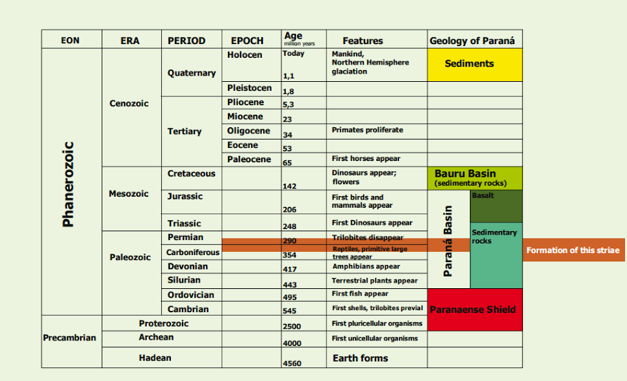
The Glacial Striations of Witmarsum are located at Colônia Witmarsum, BR-373, municipality of Palmeira, in the state of Paraná, Brazil, betwen the cities of Curitiba and Ponta Grossa. This geological formation is a record of the great glaciation that happen between 360 to 270 millions of years ago, during the Carbonifer Inferior to Permian Inferior, when all the south part of the old Supercontinent Gondwana was covered by thick layers of ice.
What is Glacier Striations?
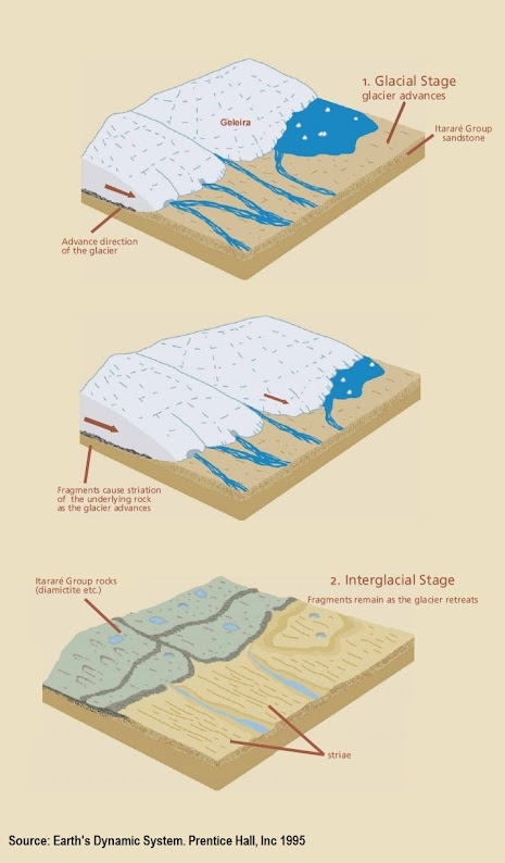
Glacier Striations are parallel lines and grooves cut into a bedrock by glacier movement, known as glacier abrasion, and they were created during the glacial period. They are important indicate the general direction of glacial movement in the region helping us to understand the formation of our planet.
How the Glacial Striations of Witmarsum were formed?
During glacial movement rocks and other sediments under great pressure from above by the glaciers weight, scratch by grinding against the bedrock forming a sequence of parallel scratches and grooves
The rock on which the striations you can see developed at this EC is a sandstone body generated by compaction and hardening of successive sand layers.
These particular layers were deposited during the Carboniferous Period 300 million years ago, when South America was still unseparated from Africa, Antarctica, Oceania and India forming a vast continent named Gondwana.
The rocks formed during this glacial event are referred to as Itararé Group, of the Basin of Parana River.
Next to the Striations, you can see an outcrop of diamictite, which is a composition of sediments consolidated as a rock, left as glaciers moved away.
In order to receive credit for this cache email me the answers for the following questions:
1) Describe in your own words, how wide and how deep are the visible striations/grooves on the bedrock here?
2) Observing the striations and reading some information next to it, what direction do you think the glacier was headed, (the smoother direction would indicate the direction the glacier was moving in)?
3) Which ones are the longest and the shortest?
Optional task:
4) Take a photo of yourself with striations in the background
Source:
Mineropar
http://www.mineropar.pr.gov.br/arquivos/File/Paineis_geologicos/EstriasGlaciaisdeWitmarsum_ingles.pdf
Estrias de Witmarsum
Este EC nos mostra um pouco a respeito de uma formação geológica rara no Brasil.
As Estrias Glaciais de Witmarsum estão localizadas na Colônia de Witmarsum, BR-373, municipio de Palmeira, no estado do Paraná, Brasil, entre as cidades de Curitiba e Ponta Grossa. Esta formação geologica é um registro da grande glaciação que aconteceu entre 360 á 270 milhões de anos atrás, durante o período Carbonifero Inferior ao Permiano Inferior, quando toda a parte sul do velho Supercontinente Gondwana era coberto por expessas camadas de gelo.

Oque são Estrias Glaciais?
Glacier Striations are parallel lines and grooves cut into a bedrock by glacier movement, known as glacier abrasion, and they were created during the glacial period. They are important indicate the general direction of glacial movement in the region helping us to understand the formation of our planet.
Como as Estrias Glaciais de Witmarsum foram formadas?
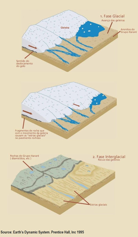
Durante o movimento glacial, rochas e outros sedimentos debaixo da grande pressão prococada pelo peso das geleiras, em contato com a rocha matriz formaram uma sequência de sulcos e cristas paralelos.
A rocha onde é possível ver as estrias dessa EC é um arenito gerado pela compactação e endurecimento de sucessivas camadas de areia.
Estas camadas particularmente foram depositadas durante o Periodo Carbonifero cerca de 300 milhões de anos atrás, quando a América do Sul ainda não havia se separado da Africa, Antarticta, Oceania e India formando o vasto continente chamado Gondwana.
As rochas formadas durante esse evento glacial são referidas como Grupo Itararé, da Bacia do Rio Parana.
Próximo das estrias, você poderá ver um afloramento de diamictitos, o qual é uma composição de sedimentos consolidado como rocha, que foram deixados pela ação da geleira.
Para receber crédito para esse cache mande por email as resposta das seguintes perguntas:
1) Descreva em suas próprias palavras, a largura e a profundidade das estrias visiveis na rocha matriz aqui?
2) Observando as estrias e lendo as informações próximas das coordenadas, qual direção a glaciação se moveu, (no sentido mais macio é que a glaciação se moveu)?
3) Quais são as mais longas e mais curtas?
Opcional:
4) Tire uma foto sua com as estrias ao fundo
Fonte:
Mineropar
http://www.mineropar.pr.gov.br/arquivos/File/Paineis_geologicos/EstriasGlaciaisdeWitmarsum_portugues.pdf