[FRA] Une côte rocheuse découpée en caps et baies
La côte rocheuse constitue l’ensemble des versants Est du massif des Albères qui plongent directement dans la mer. Le massif schisteux, érodé par les cours d’eau dévalant des pentes raides, est compartimenté par une succession de vallées perpendiculaires au littoral, en forme d’amphithéâtres et séparées par des lignes de crêtes dominant des pentes escarpées.
Des pentes schisteuses, arides et peu boisées
Les pentes abruptes des Albères présentent ajourd’hui une végétation naturelle rase de type aquis (cistes, romarins, bruyères et ajoncs). Seuls quelques sites abrités des vents violents (Tramontane de secteur nord, Marinade ou vent de la mer, et le vent d'Espagne) et n'ayant pas subi d'incendies récents, accueillent quelques boisements de chênes-lièges, chênes verts, pins parasols ou pins maritimes, que l'on retrouve parfois jusqu'en bord de mer. La végétation arborée valorise alors tout particulièrement le paysage littoral.
Des vues remarquables depuis les pentes
Les Albères constituent un balcon naturel ouvert sur la mer qui offre des panoramas remarquables sur toute la côte rocheuse, mais aussi sur les pentes du massif, ainsi que sur la plaine du Roussillon et la côte sableuse.
Les voies de communication sont de véritables « routes-paysage ». La route du littoral (RD914) serpente entre les baies et les caps et offre des vues sur les falaises schisteuses, les ports, les criques. La petite route qui grimpe sur les versants (RD86), aussi appelé route de crête, surplombe tous les sites en amphithéâtre des différents ports.
Des pentes sculptées par les terrasses viticoles
L'essentiel des pentes littorales des Albères apparaît couvert d'un vignoble en terrasses qui compose l'étonnant terroir du Cru Banyuls. Dominé par le schiste, les sols de la Côte Vermeille produisent l’identité du paysage de vigne. Les nuances de rouge marron et gris teintent le vignoble. Les sols sont très minces, pierreux et acides. Le vignoble façonne ainsi les paysages des différentes baies de la côte et constituent l'écrin des ports qui s'y sont abrités.
Les versants sont véritablement sculptés pour accueillir les ceps de vignes, avec une maîtrise exceptionnelle des techniques agricoles traditionnelles adaptées au difficile milieu naturel : pente raide, pluie violente. L’ensemble des processus/structures mises au point par l’homme afin d’exploiter les versants des Albères dessinent un paysage géométrique remarquable, caractéristique du terroir viticole de la Côte Vermeille.
Des villages-ports composant des sites bâtis remarquables dans les baies
Banyuls-sur-Mer est une petite ville construite dans une baie en forme de fer à cheval entre le cap d'Ona et le cap du Troc. Le village vivait de la pêche et de la viticulture, cette dernière ayant peu à peu pris le dessus, avec la renommée des vins de Banyuls. Aujourd'hui, elle constitue la principale activité de la ville avec le tourisme. L'urbanisation récente s'est développée autour de la vieille ville construite au fond de la baie : elle s'étend largement de part et d'autre sur les pentes avec quelques émergences de bâti qui marquent le paysage de la baie.
Le paysage de la Côte Vermeille est avant tout connu pour son paysage viticole singulier, site remarquable dont les pentes ont été sculptées par les vignerons durant des siècles. Ce paysage exprime aujourd’hui des signes de changements (friches, murets non entretenus, écoulements d’eau bétonnés…) témoignant entre autre d’un maintien difficile de l’activité viticole de plus en plus concurrencée par l’attractivité touristique dont elle est paradoxalement l’un des moteurs.
Géologie
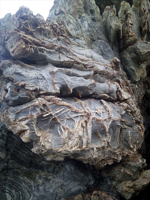
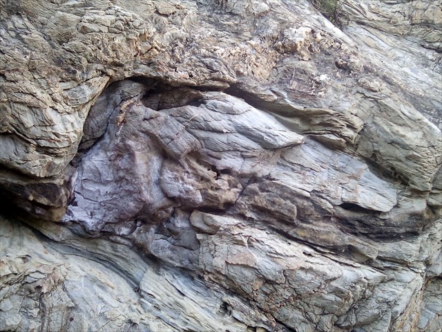
Les formations de la zone axiale de l’extrémité orientale des Pyrénées sont d’âge paléozoïque. Elles sont composées essentiellement de roches métamorphiques et cristallines déformées et intensément plissées lors des orogénèses hercynienne et alpine. Elles forment le massif des Albères, dont le coeur est occupé par les gneiss de la zone axiale, puis par les micaschistes injectés de granites. La couverture de ces formations vers l’Est correspond à l’enveloppe paléozoïque, avec des schistes du Cambro-Ordovicien à Silurien qui sont en concordance apparente sur les micaschistes et les gneiss. Ces schistes ardoisiers ou rubanés et les quartzites peuvent présenter de minces intercalations calcaires et quelques rares injections de granite. Les cours d’eau drainant ce massif des Albères a déposé dans leur partie aval des alluvions qui peuvent être grossières et épaisses. Ainsi, la Baillaury qui traverse l’agglomération de Banyuls sur Mer a déposé sur l’extrémité aval de son cours des alluvions dont l’épaisseur peut atteindre une quinzaine de mètres. Il en est de même pour le Ribéral à Cerbère. Cependant, l’extension de ces alluvions est très limitée en largeur et en longueur.
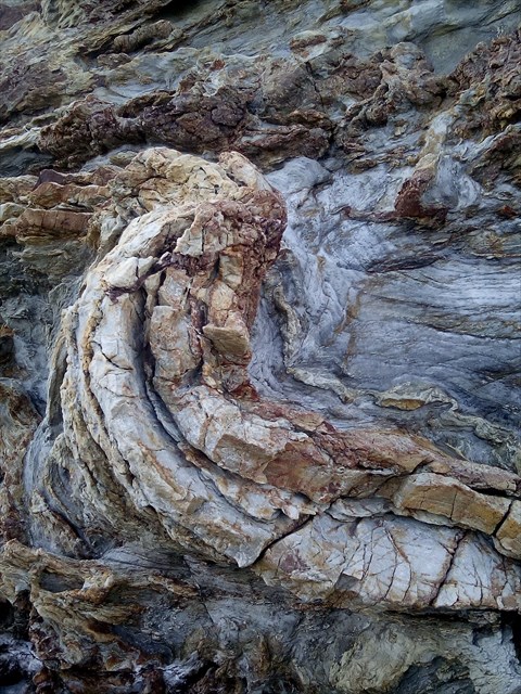
La diversité et l’histoire géomorphologique des Pyrénées, induit une réelle richesse géologique et lithographique. C’est également le cas pour le chaînon des Albères, qui constitue une entité principalement schisto-cristalline. Sa partie orientale est formée par des schistes métamorphiques en date, pour partie, du Cambrien, tandis que sa partie occidentale est plutôt composée de roches cristallines et feuilletées (gneiss, micaschistes à biotite, et parfois des calcaires). A cela s’ajoutent d’importantes et anciennes quantités d’alluvions déposées par les cours d’eau du nord et de la Plaine du Roussillon. Les roches présentes à Banyuls-sur-Mer sont donc constituées de schistes, de micaschistes et surtout de phyllades (schistes métamorphisés) grises à patine rousse ferrugineuses. Ces roches sont disséquées en longues crêtes qui séparent des llées encaissées. Le substratum est abondamment faillé et présente une micro-fracturation de surface. Son altération conduit à un sol peu épais, argileux et fortement sensible à l'érosion.
On en distingue trois grandes catégories :
·* les sols bruns occupés par le boisement en altitude,
· * les xérorankers de maquis, occupés par la bruyère, le ciste, le genêt et la lavande, qui couvrent la plus grande superficie à l'altitude intermédiaire,
·* les sols du vignoble du Banyuls caillouteux et peu épais (15 à 45 cm), en dessous de 300 m d'altitude.
Ardoises, quartzites, marbres, schistes et gneiss: roches métamorphiques
Le métamorphisme, ou « métamorphose » des roches, est l’ensemble des modifications qui transforment les roches à l’état solide, quand celles-ci sont soumises à des conditions de pression et de température différentes de celles d’origine. D’une façon générale, les roches métamorphiques se forment en profondeur, dans le contexte de la collision des plaques tectoniques et de la naissance des chaînes de montagnes. Les roches métamorphiques présentent généralement un feuilletage appelé schistosité, à savoir le fait de pouvoir se débiter en plaques plus ou moins fines et régulières. C’est le cas pour les ardoises et les schistes. De nombreuses roches métamorphiques montrent un aspect folié. Leurs minéraux sont orientés suivant des plans parallèles et disposés en lits plus ou moins marqués. Parfois, ils sont groupés en paquets allongés et forment des yeux : gneiss oeillé. Une des conséquences du métamorphisme est l’apparition des nouveaux minéraux par recombinaison des éléments chimiques en présence dans la roche : pyrite dans une ardoise, grenats dans un micaschiste…
Le métamorphisme est un phénomène qui peut affecter toutes les roches préexistantes, quelles que soit leurs natures et leurs origines. Il existe donc une grande variété de roches métamorphiques, dont les principales correspondent aux grandes familles de roches sédimentaires et éruptives.
Les marbres Les marbres sont des roches métamorphiques issues de la transformation de calcaires ou de dolomies. Dans un marbre, les éléments de calcite sont entièrement recristallisés, ce qui confère une dureté plus importante à la roche et favorise son polissage. Les marbres peuvent présenter de grandes variations de couleurs (impuretés, oxydes…) ou des veinages parfois très graphiques souvent dus à la présence d’autres substances : veines plus schisteuses ou de serpentine (cipolins). Certains peuvent être totalement blancs. On exploite des marbres dans le Pyrénées, dans le Languedoc et en Savoie.
Les schistes Les schistes sont des roches métamorphiques susceptibles de se débiter en feuillets (schistosité). Ils peuvent présenter des natures différentes. Beaucoup proviennent du métamorphisme d’anciennes argiles. Les micaschistes sont riches en micas qui leur confère un aspect brillant sur leur surface de clivage.
Définition schiste : Roche de constitution très variable, caractérisée par une texture feuilletée résultant d'une forte compression, de contraintes tectoniques ou du métamorphisme; en partic., roche sédimentaire ou faiblement métamorphique dérivant de sédiments essentiellement argileux.
Source d'informations :
http://www.banyuls-sur-mer.com/sites/banyuls-sur-mer.com/files/upload/files/partie_2_-_150439_plu-banyuls_diagnostic-161215_3-2.pdf
http://www.ctmnc.fr/images/gallerie/Quelques_notions_de_geologie.pdf
http://www.rhone-mediterranee.eaufrance.fr
Photos d'illustation de cette page : Personnelles prisent sur le site
### Afin de valider cette EARTHCACHE : ###

Loguez cette cache "Found it" et envoyez-moi vos propositions de réponses soit via mon profil, soit via la messagerie geocaching.com (Message Center), et je vous contacterai pour valider ou en cas de problème
Q1 : datez ces périodes svp : Paléozoïque/Cambrien ?
Q2 : Donnez une rapide définition pour "xéro-rankers", quel est sa traduction en français ?
- Pour les questions suivantes, il faudra vous rendre aux coordonnées indiquées :
Q3 : Aux coordonnées indiquées pour cette Eartcache, vous trouverez un bloc qui s'est détaché de la paroie (cf spoiler) déterminez les 2 principales couleurs qui le composent, que pouvez-vous en déduire concerant sa composition (matière présente) ?
Q4 : En considérant la masse volumique du schiste à +/- 2500 kg/m3 (valeur entre 1600 & 2900) estimez la masse de ce bloc ici ?
Q5 : OPTION :1. En remontant les marches du bas de la falaise (WP1) jusqu'au canon (WP2) veuillez compter les marches, merci de me communiquer ce nombre pair svp?
2. Sur le descriptif du canon, sa portée de tir est indiquée, quelle est cette dernière ?
Q6 : OPTION : si vous le souhaitez, prenez-vous (ou votre GPS) en photo devant la falaise
--------------------------------------------------------------------------------------------------------------------------------------
[ENG] A rocky coast cut in capes and bays
The rocky coast establishes the set of hillsides is of the massif of Albères which dive directly into the sea. The slaty massif, affected by streams tumbling down stiff slopes, is divided by a succession of perpendicular valleys in littoral, amphitheater-shaped and separated by ridge lines dominating steep slopes.
Slaty, dry and little afforested slopes
The abrupt slopes of Albères present today a natural vegetation shave of type aquis (cistuses, rosemaries, heathers and gorses). Only some sites sheltered from the violent winds (Tramontana of north sector, Marinade or wind of the sea, and the wind of Spain) and not having undergone recent fires, welcome some afforestations of cork oaks, holm oaks, pines or maritime pines, which we sometimes find up to the seaside. The raised vegetation values then quite particularly the littoral landscape.
Remarkable views since slopes
Albères establishes a natural balcony opened on the sea which offers remarkable panoramas on all the rocky coast, but also on the slopes of the massif, as well as on the plain of Roussillon and the sandy coast.
The communication routes are of real "roads-landscape". The road of the coast ( RD914) winds between bays and courses and offers views on the slaty cliffs, the ports, the creeks. The small road which soars on hillsides ( RD86), so called road of crest, overhangs all the sites in amphitheater of the various ports.
Slopes sculptured by the wine-making terraces
The main part of the littoral slopes of Albères seems covered with a vineyard in terraces which makes up the surprising country of the Vineyard Banyuls. Dominated by the schist, the grounds of the Ruby Coast produce the identity of the landscape of vineyard(vine). The nuances of brown and grey red colour the vineyard. Grounds are very thin, rocky and acid. The vineyard so shapes the landscapes of the various bays of the coast and establish the case of the ports which sheltered there.
Hillsides are really sculptured to welcome vine stocks, with an exceptional control of the traditional agricultural techniques adapted to the difficult natural environment: stiff slope, violent rain. All the processes / structures developments by the man to exploit the hillsides of Albères draw a remarkable, characteristic geometrical landscape of the wine-making country of the Ruby Coast.
Villages-ports making up(composing) built sites Remarkable in bays
Banyuls-sur-Mer is a town built in a bay in the shape of horseshoe between the cape of Ona and the cape of the Barter. The village lived on the fishing and on the vine growing, the latter having got the upper hand little by little, with the fame of wines of Banyuls. Today, it establishes the main activity of the city with the tourism. The recent urbanization developed around the old town built at the bottom of the bay: it extends widely on both sides over slopes with some emergences of built which mark the landscape of the bay.
The landscape of the Ruby Coast is above all known for its singular wine-making landscape, remarkable site slopes of which were sculptured by the wine growers for centuries. This landscape expresses signs of changes (fallow lands, not maintained low walls, concreted flows of water …) today testifying among others of a difficult preservation of wine-making activity more and more competed by the tourist attractiveness of which she is paradoxically the mainspring.
Geology
The formation of the axial zone of the oriental extremity of Pyrenees are of paleozoic age. They consist essentially of deformed metamorphic and crystalline rocks and intensely wrinkled during the Hercynian and alpine orogenies. They form the massif of Albères, the heart of which is occupied by gneisses of the axial zone, then by mica-schists injected by pebbleweaves(granitas). The cover(blanket) of these trainings(formations) eastward corresponds to the paleozoic envelope, with schists of Cambro-Ordovicien with Silurian which are in visible concordance on the mica-schists and the gneisses. These slate schists or rubanés and quartzites can present slender insertions limestones and some rare injections of granite. The courses of water draining this massif of Albères put down(deposited) in their part(party) approval(downstream) of the alluviums which can be unrefined and thick. So, Baillaury which crosses the urban area of Banyuls sur Mer put down(deposited) on the extremity approval(downstream) of its course of the alluviums the thickness of which can reach(affect) about fifteen meters. It's the same for Ribéral with Cerberus. However, the extension of these alluviums is very limited in width and in length.
The diversity and the history géomorphologique Pyrenees, led a real geologic and lithographic wealth. It is also the case for the link of Albères, that establishes a mainly schisto-crystalline entity. His oriental part is formed by metamorphic schists in date, partly, of the Cambrian, whereas its western part rather consists of crystalline and foliated rocks (gneisses, mica-schists in biotite, and sometimes limestones). In it are added important and former quantities of alluviums put down by the streams of the North and the Plain of Roussillon. Thus the present rocks in Banyuls-sur-Mer are established of schists, mica-schists and especially of phyllades (metamorphosed schists) intoxicate in red patina ferruginous. These rocks are dissected in long crests which separate taken(collected) llées. The substratum is abundantly faillé and present a micro-fracturing of surface. His(her,its) change leads(drives) to a ground little thick, clayey and strongly sensitive to the erosion.
We distinguish three big categories from it:
· * the brown grounds occupied by the afforestation at high altitude,
· * the xérorankers of scrubland(scrublands,resistance movement,resistance movements), occupied by the heather, the cistus, the broom and the lavender, which cover the biggest surface at the intermediate height,
· * the grounds of the vineyard of rocky and little thick Banyuls (15 in 45 cms), below 300 m of height.
Slates, quartzites, marble, schists and gneiss: metamorphic rocks
The metamorphism, or "the metamorphosis" of rocks, is all the modifications which transform rocks to the solid state, when these are subjected(submitted) to conditions of pressure and temperature different from those of origin. Generally speaking the metamorphic rocks form in depth, in the context of the collision of the tectonic plates(patches) and the birth of mountain ranges. The metamorphic rocks present generally a called lamination schistosité, worth knowing(namely) the fact of being able to sell(produce) in more or less fine and regular plates(patches). It is the case for slates and schists. Numerous metamorphic rocks show a foliate aspect. Their minerals are directed according to parallel plans and arranged in more or less marked beds. Sometimes, they are grouped in lengthened packages and form eyes: gneiss oeillé. One of the consequences of the metamorphism is the appearance of new minerals by recombination of the chemical elements in presence in the rock: pyrite in slate, garnets in a mica-schist …
The metamorphism is a phenomenon which can affect all the pre-existent rocks, whoever their natures and their origins. Thus there is a big variety of metamorphic rocks, the main clauses of which correspond to the big families of sedimentary and eruptive rocks.
The marble The marble are metamorphic rocks stemming from the transformation(processing) of limestones or from dolomites. In a marble, the elements of calcite are completely recristallisés, what confers a hardness more important for the rock and favors its polishing. The marble can present big variations of colors (impurities, oxides) or sometimes very graphic veinings often owed to the presence of the other substances: more slaty veins or of serpentine (cipolins). Some people can be totally white. We exploit(run) marble in Pyrenees, in Languedoc and in Savoie(Savoy).
Schists schists are metamorphic rocks susceptible to sell(produce) in leaves(pages) (schistosité ). They can present different natures. Many result(come) from the metamorphism of former(old) clays. The mica-schists are rich in micas which(who) confers them an aspect glittering on their surface of split(cleavage).
Definition schist: rock of very variable constitution, characterized by a foliated texture resulting from a strong compression, from tectonic constraints or from a metamorphism; there partic ., sedimentary or weakly metamorphic rock deriving from essentially clayey sediments.
### To validate this EARTHCACHE : ###
Log this cache " Found it " and send me your proposals of answers either via my profile, or via the geocaching.com messaging (Center message), and I shall contact you to validate or in case of problem
Q1: date these periods please : paleozoic / Cambrian?
Q2: give a fast definition for " xéro-rankers " which is its translation in French ?
- For the following questions, it will be necessary to return you at GZ :
Q3: At GZ indicated for this Eartcache, you will find a block which got loose from the paroie (cf spoiler) determine 2 main colors which compose it, which you can deduct from it concern her composition ( present material)?
Q4: by considering the density of the schist in +/-2500 kg / m3 (value between 1600 and 2900) estimate the mass of this block here?
Q5: OPTION :1. By going back up(by raising) the walking(steps) of bottom of the cliff ( WP1) up to the cannon (WP2) please count steps, thank you for communicating me this even number svp?
2. On the description of the cannon, its range is indicated, what is the latter?
Q6: OPTION: if you wish, take yourselves (or your GPS(GLOBAL POSITIONING SYSTEM)) in photo in front of the cliff
