This site is an SSSI so please do not damage the rocks in any way.
You will need to visit at low tide In order to walk into the quarry. (Spittal weather and tides)
You can reach the quarry by walking on the beach from the car park, around Hud's Head to N 55°44.929 W 001°58.766.
About 330 million years ago this region was in equatorial latitudes. Sea level fluctuated, so sometimes the area was beneath the sea and sometimes large rivers were flowing over the surface, maybe into an estuary. The Carboniferous sandstones in this quarry were deposited by large rivers. Cross-bedding which can be seen in the sandstones is explained in the diagram below:-
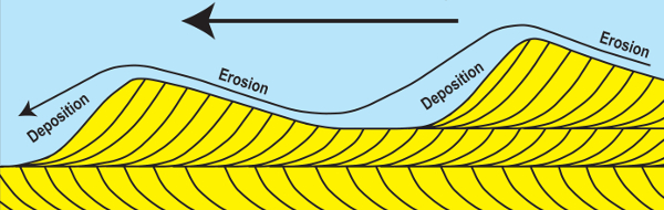
The cross bedding in the sandstone was formed by the migration of large underwater dunes as sand was carried down the river delta system. The flow of the water causes the grains to move up the shallower upstream side of the dune before cascading down the steeper leeward side, resulting in a series of advancing beds being laid down at an angle (cross-bedding). Where the next advancing dune cuts across the earlier dunes, the cross-beds are cut off.
Many of Northumberland’s sandstones have long been a major source of good freestone, (term used by masons to describe a rock that can be cut and shaped in any direction without splitting
or failing). The earliest organised quarrying and shaping of building stone was probably associated with the construction of the Iron Age forts. Extraction on a larger scale commenced during the Roman occupation, with the construction of Hadrian’s Wall (begun in AD 122), and its associated forts and gate towers.
This quarry was certainly in use in the early 1800s and probably before that. A horse-drawn railway was built in 1811 to carry stone from the quarry at Hud’s Head for the construction of the pier. It was still being used to transport coal from the Scremerston Colliery until the 1850s. It ran along the cliff top and then along the main street in Spittal.
What to do:
1. Study the building stone carefully, rubbing your fingers along it.
(a) What colour are the grains of sand?
(b) Does it feel rough or smooth?
2. Look at the whole quarry face. You can see that the rocks are tilted (dip) towards the sea.
(a) Estimate the angle of dip from the horizontal.
(b) What is the compass direction of the dip?
(c) What caused the rocks to be tilted?
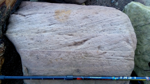
3. At N 55°44.899 W 001°58.756 there is a boulder which shows an excellent example of cross bedding. If the boulder is no longer in this position, please answer the questions from the photo. From which direction was the river current flowing?
4. At N 55°44.898 W 001°58.747 you can see chisel marks on the rock face. How do you think the blocks were removed from this quarry?
Please email your answers to me, JurassicEdie or through the Message Centre