
There are several marked paths from the Seven Sisters Country Park Centre through the Cuckmere valley. This EarthCache can be completed from the existing paths and I would ask that you stick to these.
Cuckmere Haven is an area of flood plains on the coast at the point where the river Cuckmere, and indeed the South Downs, meet the sea. It is the last undeveloped estuary in Sussex. The river at this point created meanders - a winding course that snaked across the valley floor. Rivers do not often run straight unless man interferes and confines them. The force of water flowing around a curve erodes the outside of the bend while deposits of material carried by the river build up on inside of the curve where the flow is slower and the friction greater. The large bends become horseshoe shaped and gradually these meanders get tighter as the same process occurs at the neck. Oxbow lakes are formed where the curving of a meandering river eventually gets such a fine neck that the river cuts through it and leaves the u-shape, resembling the shape of an oxbow, cut off from the main flow of the river.

Oxbow Lake at Cuckmere Haven
The precise formation of the valley here is obscure, but what is known suggests erosion of the valley edges by glacial activity and further downcutting of the chalk bedrock by water from the melting of snow, ice and glacier during spring. Chalk cliffs rise up on either side of the valley, but it relatively uncommon to see much rock before reaching the beach. The beach is shingle, the pebbles have been carried here from beaches to the west by the sea under the influence of a south-westerly wind. The chalk itself is soft and as it wears away pieces of harder flint are exposed and dislodged. Considering the volume of chalk worn away from the cliffs, small pieces of it are relatively rare among the shingle. More commonly, pieces of flint can be found mixed with the pebbles. You may also find heavy, rusty looking round lumps along the coast - these are iron pyrite, if split open (do not attempt this without appropriate equipment and experience) they reveal golden crystals, this is fool’s gold.


Diagramatic representation of the mixture of silt and clay forming the soil in a glacial valley
The Cuckmere River originates from near Heathfield in the Sussex Weald. The name is believed to come from Old Saxon meaning “fast flowing”. From its source at 130m, it drops 100m in the first 7km though it starts 32km from the sea. A few smaller rivers and streams join it as it travels into the Low Weald (tributaries) then winds through a wide gap in the South Downs. It has been diverted into two main features - at Upper Dicker to form a 6.5 acre moat at Michelham Priory, and at Arlington to form a 120 acre reservoir. The valley through which it travels to meet the sea is dominated by the chalk figure of the Long Man of Wilmington. Eventually the river becomes tidal at Milton Lock, beyond which it has been subjected to much embanking and drainage ditching.
This is fairly typical of the stages in a river’s life. At its source, a river is generally small and energetic. This “youthful stage” at the river’s upper course has a steep gradient and can zig-zag abruptly to change direction. Rivers begin high on hills or mountains and as they tumble down to lower ground, we find waterfalls, gorges, and rapids. In the “mature” stage, or middle course, of a river, the course changes more gradually, the water flowing more slowly over less steep terrain and forming a wider channel. Features formed are bigger and more substantial. Here we find shallower valleys, meanders and oxbow lakes. There are no strict boundaries to define the upper, middle and lower courses of a river, and middle course features such as meanders can be found in the old age of a river’s life. However, as it nears its end, a river has greater volume and flows even more slowly. The general landscape tends to be flatter and floodplains form causing marshy areas where the floods form and recede. River mouths tend towards being wide and deep, forming triangular shaped deltas as sediment is deposited to create many narrower channels (distributaries).
Rivers and ocean currents are a major transportation system for silt, a granular material of a size between sand and clay, whose mineral origin is quartz. Silt is created by erosion of the generally sand-sized quartz crystals of the first formed rocks. Silt is also called "rock flour" or "stone dust". It may occur as a soil (often mixed with sand or clay) and people are most familiar with it as the surface deposited at the bottom of a river or other body of water. It is also found as sediment mixed in suspension with water. Typically it has a smooth feel, powdery when dry and slippery when wet. It is fine enough to be easily carried long distances as a suspension in liquid or by air in the form of dust.

Silt
A flood occurs when a river bursts its banks and the water spills onto the floodplain. Flooding tends to be caused by heavy rain: the faster the rainwater reaches the river channel, the more likely it is to flood. The nature of the landscape around a river will influence how quickly rainwater reaches the channel. For example steep sides increase run off from the surrounding land, and non-porous surfaces will do the same; deforestation meanwhile reduces the amount of water intercepted by trees, thus increasing run-off. Here, the water table (the level below which the ground is saturated) is high which also increases run-off. In places such as this, where the river meets the sea, there can also being flooding from the tidal waters of the sea.
Floods frequently make the news as devastating events that can cause damage to homes and possessions as well as disruption to communications. However, flooding can also have positive impacts on an area. Flooding deposits fine silt onto the floodplain, making it very fertile and excellent for agriculture. People living on or near floodplains may rely upon regular flooding to help support their farming and therefore provide food.
Geological surveys have demonstrated that the course of water across this valley has changed again and again throughout history. The sea used to be a lot further away, however, analysis of the soil here shows a long history of mixed salt and fresh water (brackish water). The shingle has probably formed a barrier between the area and the sea for a long time, preventing a wholly marine influence.
A salt marsh, also known as a coastal salt marsh or a tidal marsh, is a coastal ecosystem in the intertidal zone between land and open salt water or brackish water that is regularly flooded by the tides. It is dominated by dense stands of salt-tolerant plants such as herbs, grasses, or low shrubs. These plants are essential to the stability of the salt marsh in trapping and binding sediments moved and deposited by the water. Mudflats are coastal wetlands that form when mud is deposited by tides or rivers. They are found in sheltered areas such as bays, bayous, lagoons, and estuaries. Mudflats may be viewed geologically as exposed layers of bay mud, resulting from deposition of estuarine silts, clays and remains of marine animals. A major phase of clayey silt/sand deposition is recorded in Cuckmere Haven, likely in low salt marsh or tidal mudflat environments. Overall, the borehole samples of soil in this area indicate layers of silty clay and sand, suggestive of tidal mudflats and shifting fresh water channels.


Drawings of the area from 1698 and 1778-83 respectively
In order to manage flooding, the banks of the river have been built up and drainage ditches formed along its tidal course. Earth banks are recorded here from as early as 1398. The meander formations you see today is a remnant from before man interfered with the river’s course. The oxbow lake was formed by artificially cutting of the main flow of the river to divert it straight to the sea. There are sluices to manage the water levels in the meanders, but otherwise there is no flow of water through the meanders at present. However, maintenance of the current flood defences has become expensive and alternatives to manage the area have been examined.
The "Cuckmere Restoration Project" involves a managed realignment of the river. The aim is to reconnect the flow of the river through the meanders so its path is closer to what it was in the late 19th century. This will re-create inter-tidal habitats like mudflats and salt marsh on the floodplain. Increased flow of water through the mouth of the river will create a self-cleaning river mouth. The current training walls at the mouth of the river will be removed and the straight filled in.
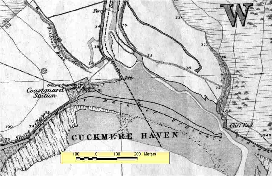
A good comparison of the changes over the last 120 years can be made by comparing the 1st edition Ordnance Survey map from 1875 and an aerial photograph from 1999. The shingle bar that deflected the Cuckmere towards the east extended much further seaward than at present. (The cliff erosion in front of the Coastguard Cottages is also well illustrated.)

In order to log this EarthCache, please go to the co-ordinates and answer the following questions. You can send the answers to me via email or through the Message Centre. For wheelchair users, go to the alternate co-ordinates, waypoint 1.
1) What colour are the river banks (including the meanders)? Why are they this colour and what does it tell you about the origin of their material?
2) How high is the bank at the published coordinates? Do you think this is natural? Why/why not?
3) From what you can see, why does the shingle of the beach provide protection?
4) Look at the grass slopes of the chalk hills - rainwater has to move from these and the hill tops to the river - please explain how you think the water does so.
5) Optionally, photos of you or your GPS in the area are always welcome
Please do not log a find until you have sent your answers. Although I try to response promptly, sometimes life gets in the way of geocaching, so you do not need to wait for me to reply before submitting your log. If there is any problem with your answers, I will be in touch to help.
With special thanks to:
martletsman - for establishing a popular CITO in this area
Natural England and East Sussex County Council - for allowing placement of this cache
GeoAwareUK3 - for all his help in preparing this EarthCache for timely publication!