Le Camp antique de Cora
FR
Le Camp antique de Cora est un site classé au titre des monuments historiques en 1971.
Le site semble avoir connu la présence d'habitat dès l'époque de l’âge de fer afin que les habitants du lieu bénéficient de la présence des hauteurs.
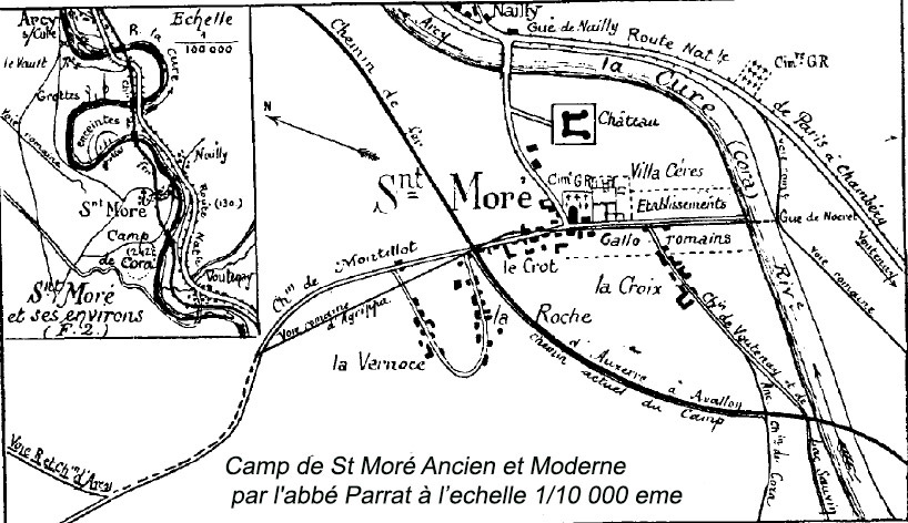
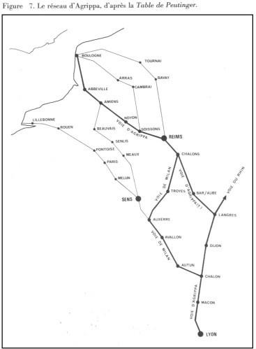
Pour la conquête de la Gaule par Jules César et la pacification de ce territoire, il est nécessaire pour les Romains de maîtriser cette nouvelle province. Auguste demande à Agrippa de lancer la construction d'une voie romaine reliant Lugdunum à la mer du Nord : la Via Agrippa de l'Océan. Agrippa fait construire des camps retranchés romains tout le long de cette voie romaine, dont celui de Cora.
Pourquoi ici ?
Au cours de l'histoire, les promontoires, en raison de leur position défensive naturelle, furent souvent utilisés comme emplacements pour la construction de forts ou de châteaux.
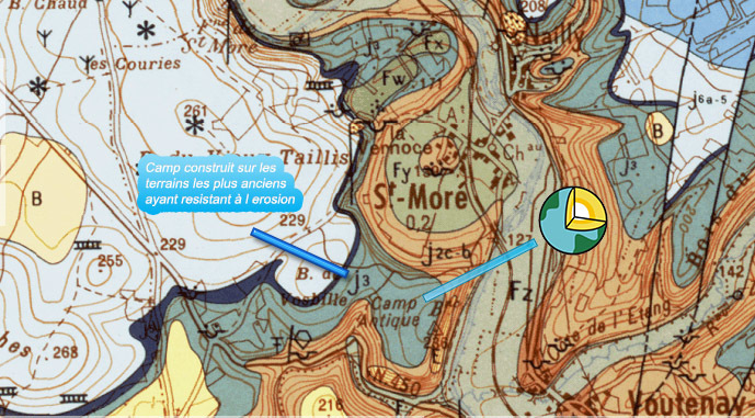
De nombreux promontoires sont composés d'une arrête rocheuse ayant résisté à l'érosion qui emporta leurs flancs, plus tendres. Il peut également s'agir d'une terre haute, constituée d'un éperon, située au confluent de deux rivières.
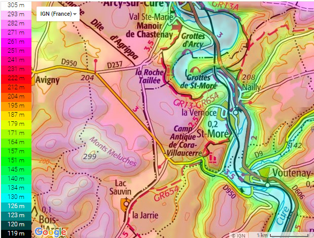
Le camp est situé 112 mètres plus haut que le village actuel de Saint-Moré. Il est bâti sur un plateau en forme d'éperon rocheux de type calcaire dont la surface est composée de pierres à lit de silex de l'époque du Callovien. Ce plateau, vestige d'un méandre fossile de l'Yonne, est en pente sur près de 30 mètres dans la direction du sud-est vers le nord-ouest.
EN
The Ancient Camp of Cora
The ancient Camp of Cora is a site classified as historical monuments in 1971.
The site seems to have known the presence of habitat from the time of the iron age so that the inhabitants of the place benefit from the presence of the heights.
For the conquest of Gaul by Julius Caesar and the pacification of this territory, it is necessary for the Romans to master this new province. Augustus asks Agrippa to launch the construction of a Roman road linking Lugdunum to the North Sea: Via Agrippa de l'Océan. Agrippa built Roman entrenched camps all along this Roman road, including that of Cora.
Why here?
Throughout history, promontories, due to their natural defensive position, were often used as sites for the construction of forts or castles.
Many promontories are composed of a rocky ridge that has resisted the erosion which carried off their more tender flanks. It can also be a high earth, consisting of a spur, located at the confluence of two rivers.
The camp is located 112 meters higher than the current village of Saint-Moré. It is built on a plateau in the shape of a rocky spur of limestone type whose surface is composed of stones with bed of flint of the Callovian period. This plateau, a vestige of a fossil meander of the Yonne, is sloping for nearly 30 meters in the direction of the south-east towards the north-west.
Source :
Infoterre.brgm.fr
http://crehangec.free.fr/bourg.htm
http://agendicum.over-blog.com/article-le-camp-de-cora-93010765.html
http://www.archive.org/stream/sancesgnraleste17arcgoog/sancesgnraleste17arcgoog_djvu.txt
http://www.persee.fr/doc/bspf_0249-7638_1909_num_6_7_7941 |
Rappel concernant les « Earthcaches »: Il n'y a pas de conteneur à rechercher ni de logbook à renseigner. Il suffit de se rendre sur les lieux et d'éxécuter les requêtes du geocacheur.
Loguez cette cache "Found it" et envoyez-moi vos propositions de réponses soit via mon profil, soit via la messagerie geocaching.com (Message Center), EN PRECISANT LE NOM ET CODE GC DE LA CACHE et je vous contacterai en cas de problème.
Il est aussi apprécié d'avoir des photos des géocacheurs sur les lieux des EarthCache. Sentez vous inspiré de poster des photos de vous lors de cette visite ( optionnelle mais sympa)
---
Reminder concerning "Earthcaches": there is neither a container to look for nor a logbook to sign.
Log in this cache " Found it " and send me your answers proposals or via my profile or via geocaching.com messaging (Message Center ) , BY PROVIDING THE NAME AND GC CODE OF THE CACHE and I will contact you in case of problems .
We also enjoy seeing photographs of people visiting this EarthCache. Please feel free to log photos of your visit...(this is entirely optional but funny)
ATTENTION, il n y a "rien" au WP, RDV aux 3 WPs pour repondre aux questions ( rien non plus au WP Parking)
BE CAREFULL, there is "nothing "in the WP, RDV to the 3 WPs to answer the questions (nothing to the WP Parking)
QUESTIONS
| WP1 Q1 A Quel est la taille du rempart en calcaire devant vous ? |
WP1 Q1 and Q1 A What is the size of the rampart in front of you? |
| WP2 Q2 Pourquoi le site est il protégé de ce côté ? |
WP2 Q2 2 Why is the site protected on this side? |
| Wp3 Q3 Depuis le panorama, ou il était possible d’observer la Via Agrippa de l'Océan, autrefois, que voyez vous maintenant ? |
Wp3 Q3 From the panorama, where it was possible to observe the Via Agrippa of the Ocean, in the past, what do you see now? |
| WP4 Q4 Que pouvez vous observer ici ? De quelle forme et en quel materiau ? |
WP4 Q4 What can you see here? What form and material? |
| Facultatif : photo ? |
Optional: a photo? |