Horton Beach is located in Port Eynon Bay on the south coast of the Gower Peninsula in Wales
It is reached from the nearby village of Horton via a steep hill, and has a car park sited a few minutes' walk away. Walk on through the dunes to the beach itself. Despite its accessibility and its popularity with surfers, the beach is usually very quiet and it has sand even at high tide.

The Gower Peninsula is, from a geological standpoint, one of the most geologically interesting areas in South Wales
The geological importance of the region is due to a magnificently exposed and practically complete sequence of the Carboniferous Limestone.
Limestones belong to the group of sedimentary rocks known as chemical sediments. They are formed in a marine environment from the precipitation of calcium carbonate, the calcium having been brought into the sea via the hydrological cycle. Fossil shells are often found in limestones. There is very little quartz in limestone as the rock is predominantly composed of calcium carbonate.
In shape, Gower is just like a great elongate rectangle, attached at its north-eastern corner by a broad projection (North Gower) to the Swansea-Llanelli mainland. The rectangle is bounded on its eastern, western and northern sides respectively by Swansea Bay, Rhosili Bay and the great Loughor-Burry Estuary.
You can use this map, in conjunction with the location map, to identify the rocks of the headlands .(*Hint its the dark green coloured stuff on the map)
The south side of the rectangle is indented by numerous bays, the largest being at Port Eynon/Horton and Oxwich. The bays are separated by headlands formed of majestic limestone cliffs, close notable examples being Oxwich Point and Pwll-du Head.
If you look really closely at the sand on Horton Beach you’ll see that it is composed of two main ingredients: quartz and shell. This is the clue to the sand’s origin. The shells come from sea animals and the quartz comes from the sandstone rocks, which do NOT form the headlands.
The sand on Horton Beach appears to be locked between the boundary headlands. Whilst over many thousands of years, these headlands have been subject to slow erosion by wind and water, breaking down rocks into smaller and smaller particles, but they are not a constituent of this beach.
The particles which have gathered on the beach, seem only to be able to escape being directly offshore to deep water. During big seas and swell, a series of rips form. A rip or tide-rip is a stretch of turbulent water in the sea, caused by the meeting of currents or abrupt changes in depth, especially one flowing outwards from the shore, causing disturbance on the surface.
If these tides are big and fast, then they erode more beach, and transport it faster and further seaward.
The term 'sand' describes a grain size, the next smaller ones would be silt and clay and the next coarser ones would be gravel .
The grain-size of a sediment is a result of certain factors like the chemical composition of the grain, the severity of the erosion and weathering, and the distance and energy the particle was transported.
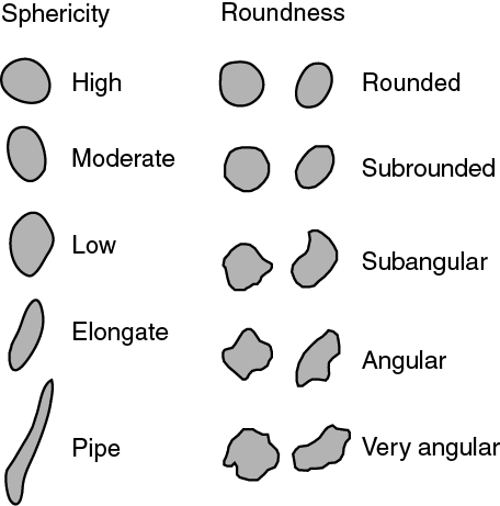
If you look closely you can see that all the particles have a slightly different shape. However the general appearance of the particles can be classified with respect to its sphericity (is the particle soccer ball shaped or is it more rugby ball shaped) and how rounded the particle is (angular or round). See the visual estimation chart below.
VISIT THE SITE, STAND AT THE GIVEN COORDINATES
Your Task
Then CONSIDER THE QUESTIONS and then message, or email us your responses. Go ahead and log your find, but PLEASE don't put answers in your log.
IF YOU DONT SEND A RESPONSE TO THE LOGGING REQUIREMENT THEN YOU LOG WILL BE DELETED WITHOUT NOTICE
1. What is the name of the rock type on the nearest headland/s? Do these rocks erode to form the sand you stand on?
2. What colour are those rocks?
Now walk on to the beach. Grab a handful of sand and spread it out on your palm. Examine the grains, a magnifying glass would be helpful. Or perhaps using the camera or your phone, zoom in on the grains (make sure it's focused). Then enlarge the photo so you can see the grains more easily.
3. Apart from the clear quartz, list the colours that make up the sand grains.
4. Classify the sand on the beach using the visual estimation chart above in terms of sphericity AND roundness.
5. Suggest why the sand is shaped as it is , and what does it suggest about the"tides"(HINT~the more powerful the tide, the finer ground are the grains)
With your log, it would nice to upload a photo of yourself on the beach, maybe holding some of the sand in your hand (but don't show a close-up photo of the actual sand grains).
By all means, DO POST PICTURES, BUT AVOID SPOILERS.
ACKNOWLEDGEMENTS
Thanks to Mikey1 for the concept
Well done "Jabawokee" on your answers and your FTF