This is an Earthcache so there is no physical container! Read the info below to discover how you log this Earthcache and find the secret word required for your Richmond GeoTour Canada 150 Passport.
Visit the mural inside the Nature House to learn more about the effects of our glacial history and the processes responsible for Richmond's land formation.
Here, 100 million years ago, ancient seabeds formed sedimentary rock under which massive pools of molten rock slowly crystallized. Uplift and erosion of this granite formed the Coast Mountains. Molten rock squeezed upward, producing volcanic formations. Enormous ice sheets began to sculpt bedrock to produce today's geological features...
The immense weight of the thick ice sheets depressed the land at least 150 metres. As the ice started to melt back 15,000 years ago the land began to return to its former level. Tremendous amounts of silt were carried to the ocean by the melt water-swollen Fraser River.
When the glaciers receded the Fraser River's mouth was located near the present-day New Westminster. Silt and sand were rapidly deposited and the land began to spread westwards. The municipality of Richmond and its 17 islands are now located on this old river delta which was once simply ocean!
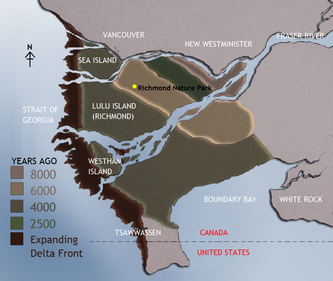
IMAGE: 8000 years ago: As high flows of water from melting glaciers rushed down the mouth of the Fraser, large coarse materials deposited and formed the first land formations where the Hamilton area of Richmond currently exists.
6000 years ago: In the higher elevation areas of this estuary, a new island formed across a short wetland channel.
4000 years ago: Materials continued to accumulate to build a larger land base.
2500 years ago: The low elevation wetland areas have now also formed land to join the two islands. This area of Richmond is known for its unique bog ecosystem, and following drainage, formed very rich soils for agriculture.
Present: The land formation continues to expand into the Strait of Georgia with the continual fluvial delta deposits.
To log this Earthcache send an email (Please do not post your answers in your log entry) to the cache owner geocaching@richmond.ca with answers to the following questions:
- How thick were the ice sheets which covered the area during the last ice age?
- Which former island was joined to the mainland by the expanding delta approximately 4000 years ago?
- Is the land mass of Richmond increasing or decreasing?
*To discover the secret word for the GeoTour passport find out how many bats are roosting in the wildlife tree in the Nature House?