EARTHCACHE INACESSIBLE A MAREE HAUTE
ET A FORT COEFFICIENT
Vérifier l’état de la marée en vous aidant du lien suivant (horaires marée)
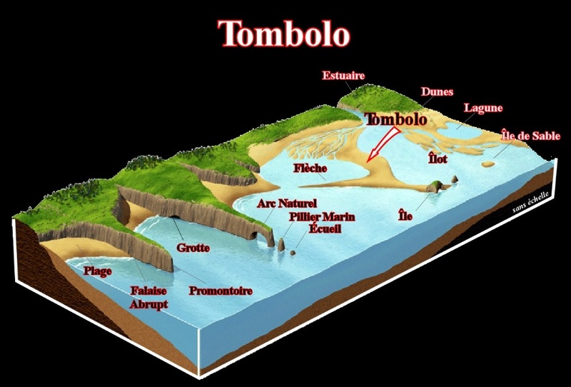
Les cordons littoraux soudés au littoral par une de leurs extrémités sont des pointes libres ou flèches de sable ou de galets (de forme allongée). Une pointe libre qui s'accroche à une île qu'elle relie au continent par sa langue de sable ou de galets constitue un tombolo
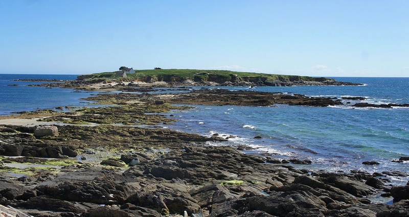
L’ile de Raguenez
est un îlot rocheux, relié à la côte par un cordon de sédiments découvert à marée basse. Une telle formation géologique s'appelle un TOMBOLO, on dit aussi un ISTHME (c'est comme vous voulez !!!)
L'accumulation de ces sédiments est favorisée par la protection offerte par l'île à l'assaut des vagues et par l'action de la houle et des courants marins.
Durant des siècles, les éléments océaniques ont déposé au fil des marées et des tempêtes, du sable, des galets et des alluvions dans l’espace qui séparait l’îlot du continent, Le dépôt sédimentaire (sableux ou graveleux) est généralement mis en place par la refraction du train de vagues due à l'île : celle-ci protège la zone située entre elle et l'autre étendue terrestre, provoquant le dépôt des sédiments où les vagues se rencontrent.
Les tombolos peuvent être simples ou multiples. Le tombolo est souvent perpendiculaire à la ligne générale du trait de côte.
Une flèche de sable, appelée tombolo, s’est ainsi façonnée.
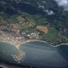
tombolo vu du ciel
POUR VALIDER CETTE CACHE, REPONDEZ AUX QUESTIONS SUIVANTES:
QUESTIONS :
Q1 : Quel est la longueur du tombolo ? Vous trouverez la réponse aux coordonnées N 47°47.273 W 003°47.982
Q2 : Quelle est la constitution du tombolo ?
Aux coordonnees N 47° 47.215 W 003° 48.025 (celle de l Earthcache)
Q3 : Que voyez vous devant vous ? (attention en cas de fortes marée vous ne pourrez pas y accéder !).
Allez ensuite aux coordonnees N 47° 47.225 W 003° 47.971
Q4 : Au sol sous vos pieds que voyez vous ? du sables, des galets, de la roche ou les trois réunis ?
puis RENDEZ VOUS AUX COORDONNEES N 47°47.296 W003° 47.972
Q5 : Vous voila devant une ancienne maison de douanier, Quelle type de roche a été utilisé pour faire les fenêtres ?
Merci d'envoyer vos réponses soit via la messagerie de mon profil soit via le centre de messagerie groundspeak, et loguez en "found it", en cas de soucis je vous contacterai
N’oublier pas de vous rendre sur l’ile faire la cache GC33WFA Ar Men Du/ The Black Stone

EARTHCACHE INACESSIBLE HIGH TIDE
AND FORT COEFFICIENT
Check the status of the tide by using the following link (tide times).
The coastal strands welded to the coast by one of their ends are free spikes or arrows of sand or pebbles (elongated). A free point which clings to an island which it connects to the continent by its tongue of sand or pebbles constitutes a tombolo
The island of Raguenez
is a rocky islet, connected to the coast by a cordon of sediments discovered at low tide. Such a geological formation is called a TOMBOLO, we also say an isthmus (it's like you want !!!)
The accumulation of these sediments is favored by the protection afforded by the island to the onslaught of waves and by the action of swell and sea currents.
For centuries, the oceanic elements deposited sand and pebbles and alluvial deposits in the space separating the island from the mainland. Tidal deposits (sandy or gravelly) By the refraction of the train of waves due to the island, which protects the zone between it and the other land, causing the deposit of the sediments where the waves meet.
Tombolos can be single or multiple. The tombolo is often perpendicular to the general line of the coastline.
An arrow of sand, called tombolo, has thus been shaped.
Tombolo from the sky
TO VALIDATE THIS CACHE, ANSWER THE FOLLOWING QUESTIONS:
QUESTIONS :
Q1: What is the length of the tombolo? You will find the answer to the coordinates N 47 ° 47.273 W 003 ° 47.982
Q2: What is the constitution of the tombolo ?
Q3: At the coordinates N 47 ° 47.215 W 003 ° 48.025 (that of the earthcache) What do you see before you ? (be careful in case of strong tide you will not be able to access!).
Then go to the coordinates N 47 ° 47.225 W 003 ° 47.971 Q4: On the ground under your feet what do you see? Sands, pebbles, rock or the three together?
Then RENDEZ YOU TO COORDINATES N 47 ° 47.296 W003 ° 47.972
Q5: Here you are in front of an old customs house, What kind of rock was used to make the Windows ?
Thank you to send your responses either through the mail or via my profile message center groundspeak, and log into "found it" in case of trouble I will contact you.
Do not forget to go on the island to make the GC33WFA Ar Men Du / The Black Stone.