Tämä geokohde tuo sinut Metsolansuolle, jossa on useitakin geologisia erityispiirteitä. Niistä kerron myös alueella sijaitsevassa multissani Metsolansuo. Tämä geokohde esittelee Metsolansuon ihmeistä pyykkilautamoreenin, jota myös De Geer -moreeniksi kutsutaan. Suomessa lukumääräisesti eniten De Geer -moreeneita on maailmanluonnonperintökohteeksi nimetyssä Merenkurkussa, missä ne esiintyvät tiheinä ja symmetrisinä kenttinä. Niitä esiintyy myös Etelä- ja Keski-Suomessa, esimerkiksi Hyvinkäällä ja Jokelassa.
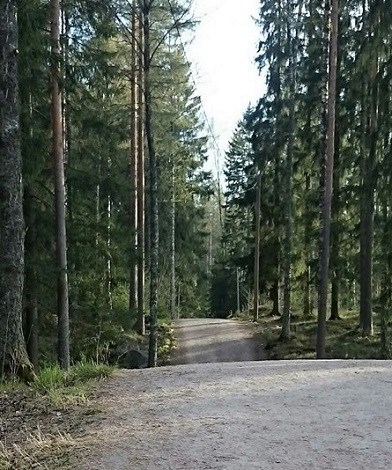
Täällä Metsolansuolla ilmiötä on helppo havainnoida, sillä aluehan on maastoltaan pääosin tasaista metsää tai suota, ja alueen ympäri kulkeva kuntopolku menee moreenikumpareiden kautta. Jos kiertää kuntopolun koko lenkin, niitä ei voi välttyä huomaamasta. Muualla metsässä muodostumia ei samalla lailla tule pantua merkille, mutta maalajikartalla niitä näkyy kyllä muuallakin.
Mannerjäätikön vetäytyessä jään reunan eteen kerrostui jäätikön puskemasta tai jäätiköltä valuneesta moreeniaineksesta jään reunan suuntaisia reunamoreeneja. Ne sisältävät pohjamoreenia, ablaatiomoreenia tai jäätikön etumaaston lajittuneita maalajeja jäätikön uudelleen kerrostamana ja poimuttamana. Tämänkaltaista reunamoreenia kutsutaan reunamuodostumaksi moreeninimityksen viitatessa ennen kaikkea ainekseen. Salpausselät, jotka ovat Suomen ja ehkäpä koko maailman tunnetuimmat kvartäärikauden muodostumat, koostuvat pääasiassa lajittuneesta aineksesta.
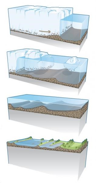
Mannerjäätikön sulaessa syntyneet pienet reunamoreenivallit esiintyvät peräkkäisten vallien parvina. Ne kuvastavat jäätikön reunan jokatalvista pysähdystä tai pientä siirtymistä. Vuodenaikojen vaikutuksen vuoksi niitä kutsutaan vuosimoreeneiksi ja niiden ensimmäisen kuvailijan ruotsalaisen Gerard de Geerin mukaan De Geer -moreeneiksi. Ulkonäkönsä mukaan niitä kutsutaan myös pyykkilautamoreeniksi, sillä pyykkilautaahan ne karttakuvassakin muistuttavat.
De Geer moreenien muodostuminen
Lähde: Botnia-AtlanticaMaailmanperintö yhteistyössä 63°N, Botnia Atlantica
De Geer -moreenit ovat aaltomaisia kapeita moreeniharjanteita, jotka voivat muodostaa laajoja kymmenien tai jopa satojen harjanteiden kenttiä. De Geer -moreenit koostuvat tavallisesti noin 5 m korkeista, 10-50 m leveistä ja 100 m pitkistä moreeniselänteistä. Joissakin tapauksissa ne voivat olla edellä mainittua korkeampia ja pitempiä. Ne esiintyvät 40-300 metrin välein suurehkoina ryhminä.
Metsolansuon esiintymä on varsin pieni rajoittuen nykytilassa ulkoilualueelle. Osa harjanteista on tavallista korkeampia. Koska alue on helposti saavutettava ja suosittu niin juoksu-, hiihto- kuin kätköilypaikkana, on perusteltua, että täällä on ilmiötä selittävä geokohde.
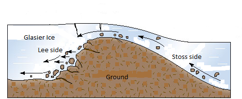
"Moreeniaaltojen" suunta on jäätikön virtaussuuntaan nähden kohtisuora. Muodoltaan yleensä epäsymmetrisillä reunamoreeneilla on heikosti kalteva vastasivu (stoss side) ja jyrkempi suojasivu (lee side). Moreeniaallon suojan puoleinen rinne on usein runsaskivisempi. De Geer -moreenit syntyivät jäätikön päätyessä matalaan veteen, aivan jäätikön kellumisrajaan. Vallitsevan käsityksen mukaisesti moreeniselänteet kehittyivät jään alla samansuuntaisesti jään reunan kanssa. De Geer-moreenit osoittavat vetäytyneen jäänreunan oletetun sijainnin.
Koordinaatit johdattavat sinut Metsolansuolla siihen kohtaan, jossa tasainen maasto muuttuu moreeniharjanteiksi. Tehtävänäsi on kulkea annetulta pisteeltä kuntorataa pitkin länteen ulkoilualueen opastaululle ja kerätä vastaukset kysymyksiin.
Kysymykset:
1.Tutki itäisintä moreeniharjannetta ja päättele sen muodon (rinteiden jyrkkyyksien) perusteella, mihin (tai kumpaan) suuntaan jää on tässä vetäytynyt. Perustele päätelmäsi. Voit joutua etsimään tietoa muualtakin kuin kätkökuvauksesta.
2. Mikä on maaston suurin korkeusero (mittaa tai arvioi)?
3. Kuinka monta harjannetta annettujen pisteiden välillä on?
4. Millä tavoin Metsolansuon kohde poikkeaa tyypillisestä pyykkilautamoreeniesiintymästä? (ainakin 1 asia)
Lähetä vastauksesi minulle profiililinkkini kautta. Sen tehtyäsi voit logata tämän earthkätkön löydetyksi. Otan yhteyttä, jos vastaukset kaipaavat korjausta. Purkkia et geokohteelta löydä.
Lähteet:
weppi.gtk.fi/aineistot/mp-opas/mrm.htm
www.merenkurkku.fi/maailmanperintoalue/geologia/moreenit/de-geer-moreenit/
Wikipedia
________________________________________________________________________________________________________________________________
ENGLISH
When I moved to Leppäkorpi, I soon visited the local outdoor recreation area Metsolansuo. Already during my first bike ride I was surprised at the consecutive ups and downs along the path. The former geologist in Vantaa City told me that these are washboard moraines. I wanted to tell this to others too and made this earthcache.
---
This earthcache introduces the washboard moraines of Metsolansuo, also called De Geer moraine. In Finland, the largest number of De Geer moraines are in Merenkurkku, Quarken or Kvarken, which is UNESCO's World Heritage Site, where the moraines appear as dense and symmetric fields. They also occur in Southern and Central Finland, for example in Hyvinkää and Jokela.
The phenomenon is easy to observe in Metsolansuo as the area is largely flat, but the trekking path runs through the moraine slopes. If you walk around the entire trail, you cannot avoid seeing the moraine ridges. In the forest you might not notice them at all.
End moraines, or terminal moraines, are ridges of unconsolidated debris deposited at the snout or end of the glacier. They usually reflect the shape of the glasier's terminus. Glaciers act much like a conveyor belt, carrying debris from the top of the glacier to the bottom where it deposits it in end moraines.
In accordance with the prevailing theory moraine ridges were formed beneath the ice parallel to the ice edge. De Geer moraines show the presumed location of the retreating ice edge. The direction of the "moraine waves" is perpendicular to the direction of flow of the ice sheet. They are usually asymmetric in shape with a gentle stoss-side and steeper lee-side. The leeward slope has often more stones. De Geer moraines were formed in the glacier ending up in shallow water. The successive ramparts reflect a winter stopover or a small annual transition of the edge of the glacier. Because of the influence of the seasons they are called annual moraines and according to their first descriptor, Swedish geologist Gerard de Geer, De Geer moraines. They are also called washboard moraines, because they resemble washboard on a map image.
The formation of De Geer moraines
Source: Botnia-AtlanticaMaailmanperintö yhteistyössä 63°N, Botnia Atlantica
De Geer moraines are narrow wavy moraines, which can form extensive fields of tens or even hundreds of ridges. The De Geer moraines usually consist of about 5 m high, 10-50 m wide and 100 m long moraines ridges. In some cases, they may be higher and longer. They occur in large groups at 40-300 m intervals.
The moraine area in Metsolansuo is quite small, limited to the current area of the recreational area. Some of the ridges are higher than usual. Since the area is easily accessible and popular among joggers, skiers and geocachers, it is justified to have an earthcache here to explaining the phenomenon.
The coordinates lead you to the point where the flat terrain turns into ridges. Your task is to walk west along the path from the given point (coordinates) to the infoboard of the area and collect answers to the following questions.
Questions:
1. Explore the shape (profile) of the easternmost hill and determine in which direction the ice retreated. Explain why.
2. What is the maximum difference in height (measured or estimated)?
3. How many ridges are there between the two reference points?
4. In what way(s) does this site differ from a typical washboard moraine? (At least one thing)
Send your answers to me through my profile link. Once done, you can log this earthcache found. I will contact you if the answers are not correct. There is no cache box.
In wintertime the exercise track is reserved for skiers.
Sources:
weppi.gtk.fi/aineistot/mp-opas/mrm.htm
www.merenkurkku.fi/maailmanperintoalue/geologia/moreenit/de-geer-moreenit/
http://www.kvarkenworldheritage.fi/the-kvarken-archipelago/
Wikipedia