|
Talegre dos Matados - Cunha Alta [Mangualde]
[PT]
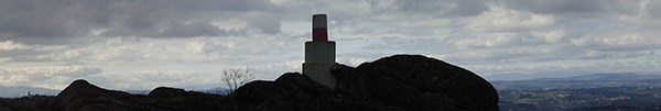
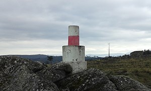
O nome deste vértice geodésico ‘Matados’ causa alguma confusão, pois a localidade mais perto dele é Cunha Alta, de qualquer forma está bem cuidado e oferece uma vista estupenda.
Para que servem estes Vértices?
Numa visão muito simplista, pode dizer-se que servem para representar e calcular a forma e a dimensão da superfície da Terra através das suas coordenadas e pontos representativos, normalmente, sítios altos, isolados e em linha de visão entre eles. A rede mundial destes pontos, serve de apoio entre outras coisas á:
- Definição de fronteiras regionais e nacionais;
- Implementação de vias de comunicação (rodo e ferroviárias) de grande dimensão;
- Construção de infraestruturas (canais, barragens, pontes, túneis, diques, etc.);
- Apoio a operações militares;
- Determinação rigorosa de grandes áreas urbanas, florestais, selvagens, etc.;
- Apoio à navegação aérea e marítima;
- Conhecer a dinâmica da Terra;
- Conhecer o campo gravítico da Terra;
- Lançamento de satélites;
- etc.
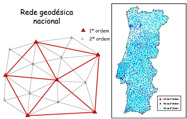
Todos estes pontos formam uma rede de triângulos, medidos com exatidão a partir de técnicas de levantamento terrestre ou espacial. A Geodesia.
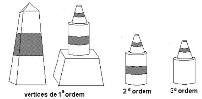
Esta rede é formada por construções (vértices geodésicos) divididas em 3 ordens de importância:
- 1ª Ordem – pirâmides distando 30 a 60Km
- 2ª Ordem – cilindros com cones no topo, listados, distando 20 a 30km
- 3ª Ordem – cilindros com cones no topo, distando 5 a 10km
[EN]
The name of this geodesic vertex 'Matados' causes some confusion, because the closest village is Cunha Alta, however is well cared and offers a great view.
What is the purpose of all geodesic vertexes?
In a very simplistic view, we can say they serve to represent and calculate the shape and size of the Earth's surface through the coordinates of the representative points , usually, high places, isolated and in line of sight between them. The worldwide network of points, serves to support among other things:
- Mark regional and national borders;
- Implementation of large communication routes (roads and rails);
- Infrastructure constructions (canals, dams, bridges, tunnels, small dams, etc.).
- Support to military operations;
- Accurate determination of large urban areas, forestry, wildlife, etc..;
- Support for air and maritime navigation;
- Understand the dynamics of the Earth;
- Know the Earth's gravitational field;
- Launch of satellites;
- Etc.
All these points form a triangle network, measured accurately from the ground or space survey techniques. The Geodesy.
This network is constituted by several constructions (geodesic vertex) divided into three orders of importance:
- 1st Order – pyramid shape with 30 to 60Km of distance between them;
- 2nd Order – cylinders with cones at the top and listed, with 20 to 30km of distance between them;
- 3rd Order – cylinders with cones at the top, with 5 to 10km of distance between them;
|