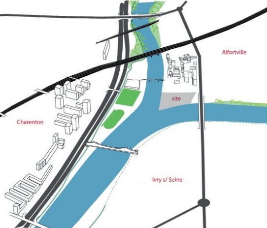
La confluence
Au point de cette earth, vous vous trouvez face à la confluence de la Seine et de la Marne, à moins de 2 km de Paris, et à 6 km du point zéro des routes de France (cathédrale Notre-Dame).
Aujourd'hui, la figure de proue de la confluence sont les restes de "Chinagora" un site regroupant divers bâtiments d'architecture chinoise (hôtels, restaurants, magasins, ..), construits en 1992 et déjà partiellement fermés.
Des projets sont à l'étude pour donner à ce site un caractère plus "vert". En attendant, on appréciera donc cette petite chinoiserie :)
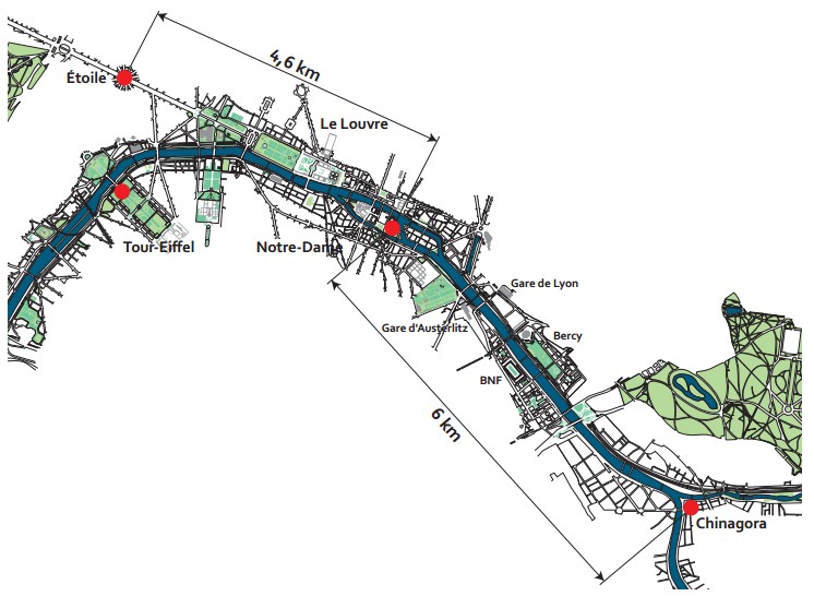
La confluence est à la périphérie de trois villes franciliennes : Alfortville, Charenton-le-Pont et Ivry-sur-Seine.
La Seine et la Marne
Il est généralement inutile de présenter ces deux grands fleuves aux franciliens, mais voilà quand même un petit rappel :
La Seine
La Seine est un fleuve français, long de 776,6 kilomètres.
La Seine coule dans le Bassin Parisien.
Sa source se situe à 446 m d'altitude à Source-Seine, en Côte-d'Or sur le plateau de Langres.
Son cours a une orientation générale du sud-est au nord-ouest.
La Seine se jette dans la Manche entre Le Havre et Honfleur.
La Marne
La Marne est une rivière française, longue de 514 km.
La Marne est située à l'Est du bassin parisien.
la Marne prend sa source sur le plateau de Langres, à Balesmes-sur-Marne (Haute-Marne), à une altitude de 423 mètres.
Principal affluent de la Seine, la Marne se jette dans la Seine entre Charenton-le-Pont et Alfortville (Val-de-Marne).
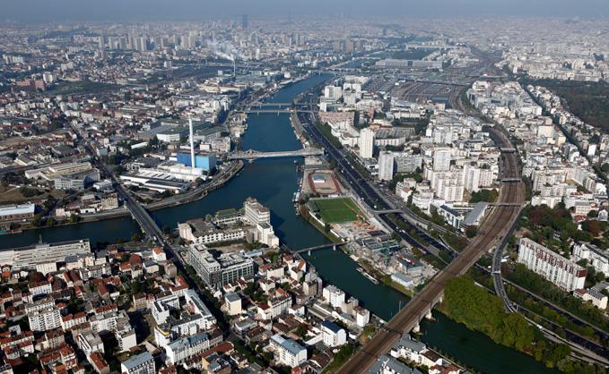
Vue aérienne
La Seine et la Marne, à leur confluence, en direction de Paris
Géologie
La Seine et la Marne, tout comme d'autres cours d'eau importants du nord de la France (Aube, Meuse, ...) prennent leur source sur le plateau de Langres.
Ce plateau s'étend entre la dépression de l'Auxois au sud-ouest, la Côte dijonnaise au sud-est, les côtes du Barrois champenois au nord-ouest et les plateaux de la Saône au nord-est. Il est indissociable du Bassin Parisien.
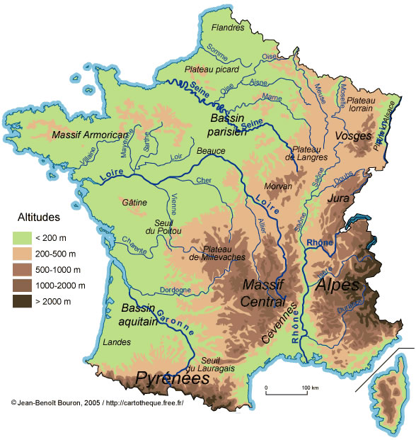
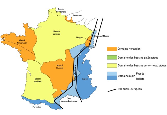
Le Bassin Parisien est une vaste cuvette sédimentaire aux roches d'origines marine, lacustre et lagunaire, puis fluviatile, accumulées au centre du bassin (environs de Château-Thierry), sur 3 000 mètres de profondeur sur un socle hercynien.
Cette cuvette est délimitée par d'anciens massifs hercyniens (Ardenne, Hunsrück, Vosges, Morvan, Massif central et Massif armoricain). Il communique avec le Bassin aquitain par le seuil du Poitou, avec la vallée de la Saône par le seuil de Bourgogne et avec la plaine germano-polonaise par la plaine flamande.
Par Teper — Travail personnel, CC BY-SA 3.0,
https://commons.wikimedia.org/w/index.php?curid=3036737
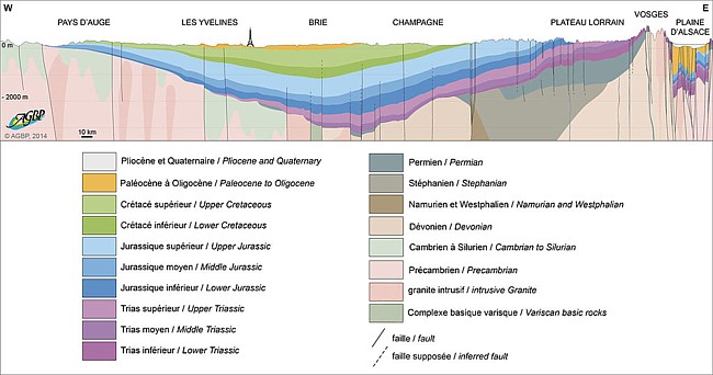
De façon schématique, on peut comparer le bassin à une série d'auréoles concentriques, les plus jeunes au centre et les plus anciennes à la périphérie, dans une configuration semblable à une pile d'assiettes, les plus petites emboîtées dans les plus grandes.
Par AGBP1964 — Travail personnel, CC BY-SA 4.0,
https://commons.wikimedia.org/w/index.php?curid=45443675
Comme on peut le voir sur le schéma ci-dessus, la formation géologique du Bassin Parisien a commencé à une ère très ancienne, mais ce sont les périodes plus récentes qui nous intéressent au vu du paysage actuel que l'on peut observer.
 La confluence de la Seine et de la Marne se situe au niveau des formations tertiaires du Bassin parisien, et plus particulièrement de l'Eocène.
Au début de l'Éocène, période de transgressions et de récessions marines, la mer, venant du nord-ouest, envahit à nouveau le centre du bassin, jusqu'en Champagne à l'est et dans le sud de l'Île-de-France au sud. Sables et argiles et calcaires se déposent. Laissant place à une lagune centrée sur Paris, elle revient pour la dernière fois pendant l'Oligocène et dépose les sables dits de Fontainebleau.
Au Miocène, le réseau hydrographique actuel, dont la Seine, est mis en place. Le bassin est alors une vaste plaine dominant à peine le niveau de la mer.
Au Pliocène, la région est soulevée par les forces tectoniques : la Seine, confrontée à une pente plus forte, s'enfonce sur place, creusant dans les couches sédimentaires : c'est le début de la formation des coteaux de Seine, visibles en Haute-Normandie.
Lors des glaciations du Pléistocène, le niveau de la mer baisse. La Seine adopte une pente plus forte et continue de creuser sa vallée. C'était à l'époque un fleuve bien plus puissant qu'aujourd'hui.
Pendant l'Holocène qui voit la fin des glaciations, la Seine, qui retrouve un cours moins violent, dépose limons et sables pour former les îles que l'on voit aujourd'hui.
Pour loguer cette cache :
Pour valider votre visite sur le site, envoyez-moi vos réponses par mail ou centre de messagerie aux questions suivantes. Vous pouvez loguer "Found it" sans attendre mon accord, je vous contacterai si nécessaire.
Certaines réponses se trouvent sur place, d'autres dans le descriptif, d'autres sur internet. Bonnes recherches :)
Q1. La Seine est un fleuve, la Marne est une rivière. Qu'est-ce qui différencie un fleuve d'une rivière ?
Q2. Pendant l'Holocène, des îles se sont formées. Un panneau vous indique le nombre d'île formées au niveau des boucles de la Marne.
a) Quel est ce nombre ?
b) Par quel type de bancs ont-elles été formées ?
c) De quoi sont-elles la conséquence ?
Q3. Sur quel plateau la Seine et la Marne prennent-elles leur source ?
Q4. Ce plateau constitue une ligne de partage des eaux.
a) Citez les trois bassins versants qu'il distribue.
b) La Seine et la Marne distribuent quel bassin versant ?
Q5. Optionnel, une photo de vous ou de votre GPS sur le site sera fortement appréciée.
The confluence
At the point of this earth, you are facing the confluence of Seine and Marne, less than 2 km from Paris, and 6 km from Notre-Dame-de-Paris Cathedral.
Today, the figurehead of the confluence is the remains of "Chinagora" a site gathering various buildings of Chinese architecture (hotels, restaurants, shops, ..), built in 1992 and already partially closed.
Projects are under consideration to give this site a more "green" character. In the meantime, we will appreciate this little chinese architecture :)
The confluence is on the outskirts of three towns in the Paris region: Alfortville, Charenton-le-Pont and Ivry-sur-Seine.
Seine and Marne
It is generally useless to present these two great rivers to the Ile-de-France, but here is a small reminder :
The Seine
The Seine is a French river, 776.6 kilometers long.
The Seine flows in the Parisian Basin.
Its source is located at 446 m of altitude in Source-Seine, in Côte-d'Or on the plateau of Langres.
It has a general orientation from south-east to north-west.
The Seine flows into the Channel between Le Havre and Honfleur.
The Marne
The Marne is a 514 km long French river.
The Marne is located in the East of the Paris basin.
The Marne rises on the plateau of Langres, at Balesmes-sur-Marne (Haute-Marne), at an altitude of 423 meters.
Main tributary of the Seine, the Marne flows into the Seine between Charenton-le-Pont and Alfortville (Val-de-Marne).
Aerial View
The Seine and the Marne, at their confluence, in the direction of Paris
Geology
The Seine and the Marne, as well as other important rivers in the north of France (Aube, Meuse, ...) originate on the plateau of Langres.
This plateau extends between the Auxois depression in the south-west, the Côte-Dijonnaise in the south-east, the coast of the Champagne barrois in the north-west and the heights of Saône in the northeast. It is inseparable from the Parisian Basin.
The Parisian Basin is a vast sedimentary basin with rocks of marine, lake and lagoon origin, then fluvial, accumulated in the center of the basin (near Chateau-Thierry) Hercynian base.
This basin is delimited by ancient Hercynian massifs (Ardenne, Hunsrück, Vosges, Morvan, Central Massif and Massif Armoricain). It communicates with the Aquitaine Basin by the threshold of Poitou, with the valley of the Saone by the threshold of Burgundy and with the German-Polish plain by the Flemish plain.
By Teper — Personal work, CC BY-SA 3.0,
https://commons.wikimedia.org/w/index.php?curid=3036737
In a schematic way, the basin can be compared to a series of concentric aureoles, the youngest in the center and the oldest in the periphery, in a configuration similar to a pile of plates, the smallest nested in the larger ones.
By AGBP1964 — Personal work, CC BY-SA 4.0,
https://commons.wikimedia.org/w/index.php?curid=45443675
As it can be seen from the diagram above, the geological formation of the Parisian Basin began in a very ancient era, but it is the more recent periods that interest us in view of the current landscape that can be observed.
The confluence of the Seine and the Marne lies at the level of the tertiary formations of the Parisian Basin, and more particularly of the Eocene.
At the beginning of the Eocene, a period of transgressions and marine recessions, the sea, coming from the north-west, again invaded the center of the basin, to Champagne in the east and in the south of Île-de-France. -France to the south. Sand and clays and limestones are deposited. Leaving a lagoon centered on Paris, it returns for the last time during the Oligocene and deposits the so-called sands of Fontainebleau.
In the Miocene, the current hydrographic network, including the Seine River, is established. The basin is then a vast plain scarcely dominating the level of the sea.
In the Pliocene, the region is raised by tectonic forces: the Seine, facing a steeper slope, sinks on the spot, digging in the sedimentary layers: this is the beginning of the formation of the Seine hillsides, visible in the Haute-Normandy.
During the glaciations of the Pleistocene, the sea level drops. The Seine takes a steeper slope and continues to dig its valley. It was at that time a much more powerful river than it is today.
During the Holocene which sees the end of the glaciations, the Seine, which regains a less violent course, deposits silts and sands to form the islands that one sees today.
To log this cache :
To validate your visit on the site, send me your answers by mail or message center to the following questions. You can log in "Found it" without waiting for my agreement, I will contact you if necessary.
Some answers are on the spot, others in the description, others on the net. Have fun :)
Q1. The Seine et the Marne are two rivers, What distinguishes these two rivers from each other ?
Q2. During the Holocene, islands were formed. A sign tells you the number of islands formed at the level of the loops of the Marne.
a) What is this number ?
b) By what type of banks ("bancs" in french, on the sign) have they been formed ?
c) From what are they the consequence (look for the "consequence" work in the sign)?
Q3. On which plateau do the Seine and the Marne take their source?
Q4. This plateau constitutes a triple watershed.
a) Name the three watershed it distributes.
b) The Seine and the Marne distribute what watershed?
Q5. Optional, a photo of you or your GPS on the site will be highly appreciated.