#2) Des deux côtés de la Manche ... EarthCache
#2) Des deux côtés de la Manche ...
-
Difficulty:
-

-
Terrain:
-

Size:  (other)
Please note Use of geocaching.com services is subject to the terms and conditions
in our disclaimer.
Le tunnel sous la Manche ... 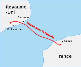 Après 138 projets de la traversée de la Manche (pont, tunnel,etc...) cet ouvrage sous-marin le plus long du monde sera inauguré le 6 mai 1994. Mais attardons-nous sur la géologie des fonds marins qui ont permis cette prouesse technologique...
UN GRAND MERCI A "h2o-hony" QUI M'A FOURNI DES INFOS POUR ELABORER CE DESCRIPTIF...
SANS OUBLIER LES REVIEWERS GeoAwareFRA1, GeoAwareEU1, et GeoAwareIB, QUI ONT CONTRIBUES A LA VALIDATION DE CETTE EARTH "SPECIALE"
****************
PREMIERS PROJETS...
En 1751, lors d'un concours académique basé sur l'amélioration des réseaux de communication entre la France et l'Angleterre, l'ingénieur Nicolas Desmarets propose la construction d'un tunnel. Divers projets de tunnel sont proposés (ex: sous forme de voûte, tubes métalliques, de pont mobile...). En 1803 un Anglais propose un premier projet, celui d'un tube métallique dans un fossé creusé au fond du détroit. Ce projet évitait donc le problème du relief sous marin. En effet à cette époque les scientifiques n’avaient aucune idée de la composition des fonds sous-marins, ce n’est qu’en 1960 que les connaissances en matière de géologie sous-marine s’approfondissent. Cependant, la pression reste un problème. Le projet retenu est celui d'une voie ferrée sous-marine pour laquelle les travaux débuteront en 1876.
LE CHOIX DE L'EMPLACEMENT !!!
Une des difficultés de la solution en tunnel était l'incertitude géologique et la gestion du risque sismique, difficultés amoindries pour la solution « pont », mais qui génère d'autres problèmes (dont risques de collision dans un détroit qui compte parmi les plus fréquentés au monde par le trafic maritime) Tracé dans la couche dite de la craie bleue (Cénomanien) à une profondeur de 40 mètres sous le fond de la mer , le tunnel sous la Manche comprend en fait trois galeries. (2 de circulation des trains et 1 de service au centre)
LE PROJET DEFINITIF...
Le projet du Tunnel sous La Manche a nécessité de nombreuses études parmi lesquelles la géologie a occupé une place importante et même primordiale au début. Ces études ont permis de choisir les outils de construction les plus efficaces. Ainsi grâce à elles les travaux se sont déroulés comme prévu et aucune mauvaise surprise n'a été constatée. C’est entre Coquelles et Folkestone(Angleterre) que la distance est la plus réduite(33,5 km). De plus, la mer n'est pas profonde, environ 40m. Cependant, le tunnel a été construit 90m en dessous de la surface; donc 40m d'eau et 50m de roche dans la couche appelée craie bleue.
LES COUCHES GEOLOGIQUES DE L'IMPLANTATION...  Le sol est constitué de différentes strates : -la première, est une couche de sédiments. -la deuxième, est un mélange de craie blanche et grise, mais le problème est que la craie est poreuse. -la troisième, est une couche de craie bleue. Elle est adaptée pour le tunnel car elle est très résistante et très étanche. La craie est une roche sédimentaire carbonatée contenant plus de 90% de carbonate de calcium. Elle est d'origine marine formée par l'accumulation des restes de coccolithophoridés ( algues calcaires unicellulaires) dans des bassins de moins de 300 m de profondeur. D'autres espèces planctoniques sont présentes dans la craie mais aussi des espèces de plus grande taille (oursins, ammonites...). En effet cette couche de craie bleue, vieille de 100 millions d'années, résistante mais pas trop dure (dureté 3 à 5) peu fracturée donc peu perméable, mais juste assez épaisse (25 à 35m) pour bien contenir les trois tunnels, est située à une profondeur raisonnable : 30 à 60 m sous le fond de la mer. Par contre, la craie grise est plus perméable, soit 100 fois plus que la craie bleue. On trouve 60% de calcimétrie pour la craie grise (mesure du calcium dans la matière) contre 59% pour la craie bleue, ce qui est quasiment similaire. - Après, c'est une couche d'argile dite « gonflante ». L'argile est étanche mais cette matière est très caoutchouteuse. C'est pourquoi les constructeurs ont décidé d'utiliser la couche de craie bleue pour creuser le tunnel sans qu'il ne dépasse ni au dessus, dans la craie grise ( car il y aurait des risques de venues d'eaux nombreuses et dangereuses) ni au dessous, dans l'argile ( l'argile du Gault qui risquerait de bloquer les tunneliers). La tourtia est une couche constituée de dépôts d'argile et de sable. En creusant, les géologues ont trouvé dans la craie bleue un coquillage, ce qui prouve que c'est une matière très conservatrice, et ils ont ainsi pu localiser le site et tracer les plans du tunnel.
ET VOICI LE RESULTAT ...
Le sol est constitué de différentes strates : -la première, est une couche de sédiments. -la deuxième, est un mélange de craie blanche et grise, mais le problème est que la craie est poreuse. -la troisième, est une couche de craie bleue. Elle est adaptée pour le tunnel car elle est très résistante et très étanche. La craie est une roche sédimentaire carbonatée contenant plus de 90% de carbonate de calcium. Elle est d'origine marine formée par l'accumulation des restes de coccolithophoridés ( algues calcaires unicellulaires) dans des bassins de moins de 300 m de profondeur. D'autres espèces planctoniques sont présentes dans la craie mais aussi des espèces de plus grande taille (oursins, ammonites...). En effet cette couche de craie bleue, vieille de 100 millions d'années, résistante mais pas trop dure (dureté 3 à 5) peu fracturée donc peu perméable, mais juste assez épaisse (25 à 35m) pour bien contenir les trois tunnels, est située à une profondeur raisonnable : 30 à 60 m sous le fond de la mer. Par contre, la craie grise est plus perméable, soit 100 fois plus que la craie bleue. On trouve 60% de calcimétrie pour la craie grise (mesure du calcium dans la matière) contre 59% pour la craie bleue, ce qui est quasiment similaire. - Après, c'est une couche d'argile dite « gonflante ». L'argile est étanche mais cette matière est très caoutchouteuse. C'est pourquoi les constructeurs ont décidé d'utiliser la couche de craie bleue pour creuser le tunnel sans qu'il ne dépasse ni au dessus, dans la craie grise ( car il y aurait des risques de venues d'eaux nombreuses et dangereuses) ni au dessous, dans l'argile ( l'argile du Gault qui risquerait de bloquer les tunneliers). La tourtia est une couche constituée de dépôts d'argile et de sable. En creusant, les géologues ont trouvé dans la craie bleue un coquillage, ce qui prouve que c'est une matière très conservatrice, et ils ont ainsi pu localiser le site et tracer les plans du tunnel.
ET VOICI LE RESULTAT ...  PAS DE CACHE A TROUVER, NI DE LOGBOOK A REMPLIR...
NE CHERCHEZ PAS A VOUS RENDRE AUX COORDONNEES DU DESCRIPTIF.
PAS DE CACHE A TROUVER, NI DE LOGBOOK A REMPLIR...
NE CHERCHEZ PAS A VOUS RENDRE AUX COORDONNEES DU DESCRIPTIF.
(point le plus bas du tunnel,vous n'y arriverez pas, et ça ne sert à rien !!!)
REPONDRE AUX QUESTIONS SUIVANTES...
1) Citez les 3 strates principales du lieu de l'implantation du tunnel ?
2) De quand date la craie bleue (époque et age en Millions d'Années) ?
3) Quest-ce-que la "Tourtia" ?
4) Défaut d'alignement à la jonction lors du creusement du tunnel (en mm) ?
5) Profondeur maxi du tunnel sous la mer?
6) Volume de matériaux extraits lors du creusement (en millions de tonnes) ?
7) WP1: (côté Français) Voir questions détaillées?
8) WP2: (côté Anglais) Voir questions détaillées?
9) Photo optionnelle du ticket de traversée...
Loguez cette cache "Found it" et envoyez-moi vos propositions de réponses soit via mon profil, soit via la messagerie geocaching.com (Message Center), et je vous contacterai en cas de problème.
 The Channel Tunnel ...
After 138 projects crossing the Channel (bridge, tunnel, etc ...) this longest submarine tunnel in the world will be inaugurated on May 6, 1994. Here, let us focus on the geology of the seabed that has allowed this technological prowess ...
FIRST PROJECT ...
In 1751, in an academic competition based on the improvement of communication networks between France and England, engineer Nicolas Desmarets proposed the construction of a tunnel. Various tunnel projects are proposed (eg in the form of vault, metal tubes, mobile deck ...). In 1803 an Englishman proposed a first project, that of a metal tube in a ditch dug at the bottom of the strait. This project thus avoided the problem of underwater relief. Indeed, at that time, scientists had no idea of the composition of the seabed, it was not until 1960 that the knowledge in underwater geology deepened. However, pressure remains a problem. The project chosen is that of an underwater railway for which work will begin in 1876.
THE CHOICE OF LOCATION !!!
One of the difficulties of the tunnel solution was the geological uncertainty and the management of the seismic risk, difficulties reduced for the "bridge" solution , But which generates other problems (including risks of collision in a strait which is one of the most frequented in the world by maritime traffic). Traced in the so-called blue chalk layer (Cenomanian) to a depth of 40 meters below the bottom Of the sea, the Channel Tunnel actually comprises three galleries. (2 trains and 1 service center)
THE DEFINITIVE PROJECT ...
The project of the Channel Tunnel necessitated numerous studies among which geology occupied an important and even primordial place at the beginning. These studies made it possible to choose the most efficient construction tools. Thanks to them, the work was carried out as planned and no unpleasant surprise was found. It is between Coquelles and Folkestone (England) that the distance is the smallest (33,5 km). In addition, the sea is not deep, about 40m. However, the tunnel was built 90m below the surface; Therefore 40m of water and 50m of rock in the layer called blue chalk.
THE GEOLOGICAL LAYERS OF THE IMPLANTATION ...
The soil is made up of different strata: - the first, is a layer of sediment. -the second, is a mixture of white and gray chalk, but the problem is that the chalk is porous. -the third, is a layer of blue chalk. It is suitable for the tunnel because it is very resistant and very waterproof. Chalk is a carbonated sedimentary rock containing more than 90% calcium carbonate. It is of marine origin formed by the accumulation of the remains of coccolithophorids (unicellular limestone algae) in basins less than 300 m deep. Other planktonic species are present in chalk but also larger species (sea urchins, ammonites ...). Indeed, this layer of blue chalk, 100 million years old, resistant but not too hard (hardness 3 to 5) fractured so little permeable, but just thick enough (25 to 35m) to contain the three tunnels, is Located at a reasonable depth: 30 to 60 m under the sea bottom. However, gray chalk is more permeable, 100 times more than blue chalk. There are 60% calcimetry for gray chalk (calcium measurement in the material) compared to 59% for blue chalk, which is almost similar. - Afterwards, it is a layer of clay called "swelling". The clay is waterproof but this material is very rubbery. This is why the manufacturers decided to use the blue chalk layer to dig the tunnel without going over it in the gray chalk (because there would be risks of coming from numerous and dangerous waters) Or below, in the clay (the clay of the Gault which could block the tunnel boring machines). Tourtia is a layer of clay and sand deposits. In digging, the geologists found a shell in blue chalk, which proves that it is a very conservative matter, and they were able to locate the site and draw the plans of the tunnel.
HERE'S THE RESULT ...
NO COVER TO BE FINDED, OR LOGBOOK TO BE COMPLETED ...
DO NOT LOOK AT YOUR DESCRIPTIVE COORDINATES.
The Channel Tunnel ...
After 138 projects crossing the Channel (bridge, tunnel, etc ...) this longest submarine tunnel in the world will be inaugurated on May 6, 1994. Here, let us focus on the geology of the seabed that has allowed this technological prowess ...
FIRST PROJECT ...
In 1751, in an academic competition based on the improvement of communication networks between France and England, engineer Nicolas Desmarets proposed the construction of a tunnel. Various tunnel projects are proposed (eg in the form of vault, metal tubes, mobile deck ...). In 1803 an Englishman proposed a first project, that of a metal tube in a ditch dug at the bottom of the strait. This project thus avoided the problem of underwater relief. Indeed, at that time, scientists had no idea of the composition of the seabed, it was not until 1960 that the knowledge in underwater geology deepened. However, pressure remains a problem. The project chosen is that of an underwater railway for which work will begin in 1876.
THE CHOICE OF LOCATION !!!
One of the difficulties of the tunnel solution was the geological uncertainty and the management of the seismic risk, difficulties reduced for the "bridge" solution , But which generates other problems (including risks of collision in a strait which is one of the most frequented in the world by maritime traffic). Traced in the so-called blue chalk layer (Cenomanian) to a depth of 40 meters below the bottom Of the sea, the Channel Tunnel actually comprises three galleries. (2 trains and 1 service center)
THE DEFINITIVE PROJECT ...
The project of the Channel Tunnel necessitated numerous studies among which geology occupied an important and even primordial place at the beginning. These studies made it possible to choose the most efficient construction tools. Thanks to them, the work was carried out as planned and no unpleasant surprise was found. It is between Coquelles and Folkestone (England) that the distance is the smallest (33,5 km). In addition, the sea is not deep, about 40m. However, the tunnel was built 90m below the surface; Therefore 40m of water and 50m of rock in the layer called blue chalk.
THE GEOLOGICAL LAYERS OF THE IMPLANTATION ...
The soil is made up of different strata: - the first, is a layer of sediment. -the second, is a mixture of white and gray chalk, but the problem is that the chalk is porous. -the third, is a layer of blue chalk. It is suitable for the tunnel because it is very resistant and very waterproof. Chalk is a carbonated sedimentary rock containing more than 90% calcium carbonate. It is of marine origin formed by the accumulation of the remains of coccolithophorids (unicellular limestone algae) in basins less than 300 m deep. Other planktonic species are present in chalk but also larger species (sea urchins, ammonites ...). Indeed, this layer of blue chalk, 100 million years old, resistant but not too hard (hardness 3 to 5) fractured so little permeable, but just thick enough (25 to 35m) to contain the three tunnels, is Located at a reasonable depth: 30 to 60 m under the sea bottom. However, gray chalk is more permeable, 100 times more than blue chalk. There are 60% calcimetry for gray chalk (calcium measurement in the material) compared to 59% for blue chalk, which is almost similar. - Afterwards, it is a layer of clay called "swelling". The clay is waterproof but this material is very rubbery. This is why the manufacturers decided to use the blue chalk layer to dig the tunnel without going over it in the gray chalk (because there would be risks of coming from numerous and dangerous waters) Or below, in the clay (the clay of the Gault which could block the tunnel boring machines). Tourtia is a layer of clay and sand deposits. In digging, the geologists found a shell in blue chalk, which proves that it is a very conservative matter, and they were able to locate the site and draw the plans of the tunnel.
HERE'S THE RESULT ...
NO COVER TO BE FINDED, OR LOGBOOK TO BE COMPLETED ...
DO NOT LOOK AT YOUR DESCRIPTIVE COORDINATES.
(The lowest point of the tunnel, you will not get there, and it is useless!)
RESPOND TO THE FOLLOWING QUESTIONS ......
1) Name the 3 main strata of the site of the tunnel?
2) When did the blue chalk (age and age in Millions of years)?
3) What is the "Tourtia"?
4) Misalignment at the junction when tunneling (mm)?
5) Maximum depth of the underwater tunnel?
6) Volume of material extracted during digging (million tonnes)?
7) WP1: (French side) See detailed questions?
8) WP2: (English side) See detailed questions?
9) Optional photo of the crossing ticket.
Log in this "Found it" cache and send me your suggestions for answers either via my profile or via the geocaching.com message center, and I will contact you if there is a problem.
 BELLE BALADE, JE VOUS ATTENDS.../BEAUTIFUL BALAD, I WAIT YOU ..
Additional Hints
(Decrypt)
Cbffvovyvgé qr ybthre prggr pnpur qrf 2 pôgéf qr yn Znapur !!!
*******************************
Cbffvovyvgl bs ybttvat guvf pnpur ba obgu fvqrf bs gur Punaary !!!