
 Note: for accessability there is an almost idential earthcache on the west side of the park; these are educational remember.
The geologic history of the Pinnacles National Park begins about 60 million years ago and about 195 miles south of here near present day Landcaster. At that time, an oceanic plate (a piece of the crust of the earth) called the Farallon Plate and the continental North American Plate were moving toward each other.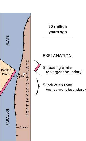 Instead of crunching together like two cars, the Farallon Plate was directed down into the earth while the North American Plate stayed on top. This plate movement of an oceanic plate diving down under a continental plate is called subduction. During the subduction, portions of the Farallon Plate were scraped off the top and pushed up against the edge of the North American Plate forming much of the north-south coastal mountains. As the Farallon Plate went deeper in to the earth, it began to melt under the North American Plate.
from: USGS
The melting Farallon Plate formed large amounts of magma (melted rock) that moved up through weak areas along the edge of the North American Plate forming volcanoes. It is estimated that the volcano that formed the Pinnacles became active about 22 to 23 million years ago, the Miocene. While it was active, it formed an estimated 8,000 foot high mountain, 15 miles long and 5 miles wide. David Warburton of Florida Atlantic University puts that as a little smaller than Mt. St. Helens.
At some point, the North American Plate migrated over the spreading center that was the boundary between the Farallon and Pacific Plate. The spreading center is a plate margin where the plates are constantly moving away from each other and magma is continually filling in the space between them. Once that happened, the Farallon Plate no longer existed, and Pinnacles Volcano became extinct.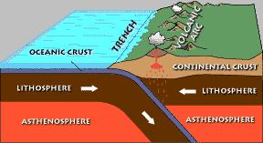
from: NPS
Instead of moving toward each other, the Pacific Plate was moving northwest relative to the North American Plate. This changed the plate boundary to the transform fault we are familiar with today. As it happened, the Pinnacles Volcano ended up straddling the fault line that formed between the plates. It is estimated that the Pacific Plate has moved approximately 1.5 inches per year resulting in the portion of the volcano on the Pacific Plate moving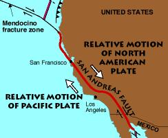 195 miles northwest to become the Pinnacles National Monument relative to the rest of the volcano that is on the North American Plate. The portion that is on the North American Plate is called the Neenach Formation (GCQ5FZ) and is located near Landcaster.
from: NPS
Logging requirements:
Send me a note with :
- The text "GC70465 Split Volcano - Pinnacles NP East EarthCache" on the first line
- The number of people in your group.
- Examine the shape of the rock formations. What about them suggests that they are relatively recently exposed to weathering.
The above information was compiled from NPS documentation and the following sources:
- Geology of National Parks, GLY 3164, © 2004 by David L. Warburton (http://www.geology.fau.edu/Resources/CourseWebPages/Fall2004/GLY3164/NPPINNNM.htm)
- San Francisco Bay Area Network I & M Program Monitoring Report: Phase I October 2002 version 7/18/2005 Jennifer Bjork http://www2.nature.nps.gov/geology/parks/pinn/#geology
- Stanley, Richard G., et. Al. , 2000, Locaitons and Ages of Middle Tertiary Volcanic Centers in Coastal California, Open-File Report 00-154, USGS http://vulcan.wr.usgs.gov/LivingWith/VolcanicPast/Places/volcanic_past_california.html
The original work on the Pinnicals and Neenach formation was published in:
- Matthews, Vincent, III, 1973a, Geology of the Pinnacles Volcanic Formation and the Neenach Volcanic Formation and their bearing on the San Andreas fault problem [Ph.D. thesis]: Santa Cruz, University of California, 214 p.
- ———1973b, Pinnacles–Neenach correlation—a restriction for models of the origin of the Transverse Ranges and the big bend in the San Andreas fault: Geological Society of America Bulletin, v. 84, no. 2, p. 683–688.
- USGS, http://pubs.usgs.gov/publications/text/Farallon.html"
Unfortunately, I did not get a chance to review these works.
I was also unable to review the following article
Weigand, P. W., and Swisher, C. C., III, 1991, Possible miscorrelation of the Pinnacles and Neenach Volcanic Formations: Evidence from new 40Ar/39Ar dates: Eos, v. 72, p. 577
Placement approved by the Pinnacles
National Monument