il y a 2 gouls : le goul de la tannerie (ou petit goul) et le goul du pont (ou grand goul)
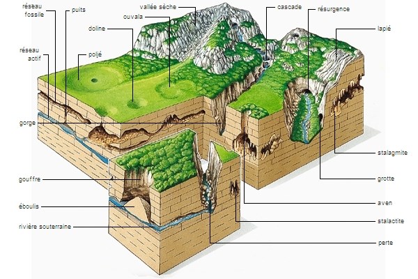
il s'agit de deux résurgences de type "vauclusien" ( réapparition à l'air libre, sous forme d'une grosse source, d'une nappe d'eau ou d'une rivière souterraine)
Le bassin d’alimentation des deux résurgences est le plateau du Laoul. Une coloration à partir de la grotte de la Pascaloune, située à 7,5 km, a démontré une liaison directe avec les deux gouls de Tourne. d'apparence simple, ces 2 gouls cachent un grand labyrinthe de galeries descendant très profondément et dont on ne connais pas la fin.
Les deux résurgences sont très appréciées par les plongeurs qui continuent de dresser la topographie de ces deux gouls et battent des records de plongée.
GOUL DE LA TANNERIE
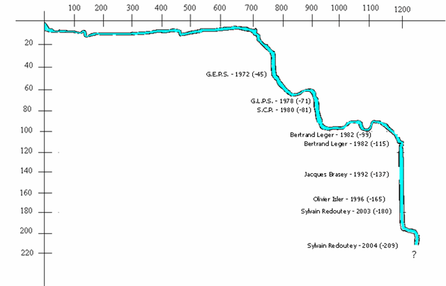
le goul de la Tannerie doit son nom à une ancienne tannerie située à proximité. A ce jour ce goul a été exploré sur un peu plus de 1250m. Les dimensions moyennes de la galerie principale sont les suivantes : 0 - 100m : 80 cm de haut sur 3m de large, jusqu'au canyon surmonté d'une cloche d'air. 100m - 500m : 1m de haut pour 5m de large avec une zone présentant des dédoublements de galerie.500m - 700m : la section se circularise et avoisine les 3m². A 700m, un puits s'enfonce rapidement en une succession de redans verticaux. En plan, il effectue une boucle complète. On accuse 45m de dénivelé entre les cotes 699m et 804m. En plan après un premier tronçon de 200m environ orienté 280°, la suite du conduit présente sections qui s'alignent sur les axes majeurs des accidents locaux (140 - 150°). Localement, des cheminements sont influencés par des fractures transverses. De 804m (-60) à 926m (-98), à la sortie de la boucle, la galerie reprend la direction dominante de 145° jusqu'au puits à 926m. La section moyenne est de 4,5 m². A partir du fond d'un puits à -87, une galerie (3 x 4m) en légère pente conduit à un nouveau ressaut (-95). A sa base (-102) un conduit esthétiquement remarquable se développe à l'horizontale durant une cinquantaine de mètres jusqu'à l'amorce d'un puits remontant, à 945m de l'entrée. Entre 926m et 1020m, la galerie présente en plan une succession de tronçons en ligne brisée dont les azimuts principaux sont 120° et 70°. Le puits plonge verticalement jusqu'à -113, puis la pente se modère pour plonger à 60° jusqu'à -165 où le puits redevient vertical. La descente se poursuit jusqu'à -200 mètres. Là, un court tronçon de galerie horizontale conduit en tête d'un nouveau puits, descendu jusqu'à -209m, arrêt sur rien. Il semblerait que la suite se présente sous une succession de redans verticaux.
LE GOUL DU PONT
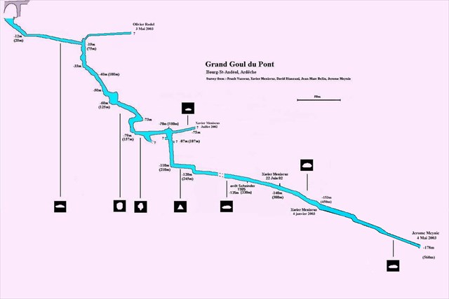
il doit son nom à la proximité d'un pont qui se situe juste à côté. A ce jour ce goul a été exploré sur 575 m, pour une profondeur de -185 m.
Description de la cavité La vasque d’entrée glisse le long d’une pente de galets jusqu’à un rétrécissement situé à – 12 m. Une galerie quasi horizontale de section ovalisée nous amène au sommet du premier puits situé à 75 m de l’entrée par – 18 m de profondeur. La galerie plonge à la verticale jusqu’à – 33 m puis enchaîne une succession de redans verticaux jusqu’à 125 m de l’entrée par – 60 m. La section se réduit et de cours tronçons horizontaux ralentissent la descente jusqu’à 157 m de l’entrée par – 79 m. La galerie continue à l’horizontale sur 25m, avec une dimension de 1,2 x2 m, jusqu’à un élargissement à 180 m. Vers la côte 165m, une galerie basse se prolonge durant une vingtaine de mètres, en direction du sud-ouest. Un puits vertical plonge du point 180m jusqu’au point 210m par – 110. Après avoir parcouru une galerie en pente douce de section triangulaire sur 25 m, un nouveau puits permet d’atteindre – 120 m à 245m de l’entrée. Là commence la galerie profonde d’une section d’environ 1 à 1,5 m de haut pour 2 à 2,5 m de large. Elle est sinueuse et descend en pente douce affectée elle aussi de redans verticaux. Vers – 130 m, la pente s’accentue sensiblement (20°). Arrêt de l’exploration à 575 m de l’entrée par – 185 m. La suite se présente sous la forme d’un laminoir horizontal dont la dimension est de 4m de large par 80cm de haut et le sol recouvert d’une importante épaisseur de glaise fine et de divers blocs rocheux.
pour valider cette earth-cache, il vous faudra m'envoyer par la messagerie vos réponses aux questions suivantes :
1° - quel est le nom du bassin d'alimentation de ces 2 résurgences
2° - sur quelle distance le goul de la tannerie a-t il été déjà exploré
3° - quelle est l'orientation des résurgences ?
"Loguez cette cache "Found it" et envoyez-moi vos propositions de réponses soit via mon profil, soit via la messagerie geocaching.com (Message Center), et je vous contacterai en cas de problème."
ENGLISH (google translation)
This earth cache will allow you to discover a well-known component of a karstic relief: the resurgence through these 2 gouls particularly noteworthy.
For reminder: The originality of the karstic relief results from the property that the limestone has to be dissolved by water.
To validate this earth-cache, you will have to send me by mail your answers to the following questions:
1 ° - what is the name of the feeding basin for these two resurgences
2° - How far has the goul of the tannery been explored
3 ° -What is the direction of the resurgences?
"Log in this" Found it "cache and send me your responses either via my profile or via geocaching.com (Message Center), and I'll contact you if there is a problem."
There are 2 gouls: the goul of the tannery (or small goul) and the goul of the bridge (or big goul)
These are two resurgences of the "Vauclusian" type (reappearance in the open air, in the form of a large spring, an underground river)
The feeding basin for the two resurgences is the Laoul plateau. A coloration of the water from the Pascaloune cave, located 7.5 km, demonstrated a direct connection with the two Gouls de Tourne. Of a simple appearance, these 2 guls hide a great labyrinth of galleries descending very deeply and whose end we do not know.
The two resurgences are very appreciated by the divers who continue to draw up the topography of these two gouls and beat diving records.
le goule de la tannerie
The Goul de la Tannerie owes its name to an old tannery located nearby. To date this goul has been explored on a little more than 1250m. The average dimensions of the main gallery are the following: 0 - 100m: 80 cm high by 3m wide, up to the canyon surmounted by an air bell. 100m - 500m: 1m high for 5m wide with an area with gallery duplications.500m - 700m: the section circularizes and borders the 3sqm. At 700m, a well sinks rapidly in a succession of vertical slopes. In plan, it performs a complete loop. There are 45m of difference in altitude between the dimensions 699m and 804m. In plan after a first section of about 200m oriented 280 °, the continuation of the duct presents sections which are aligned on the major axes of the local accidents (140 - 150 °). Locally, pathways are influenced by transverse fractures. From 804m (-60) to 926m (-98), at the exit of the loop, the gallery resumes the dominant direction of 145 ° to the well at 926m. The average section is 4.5 m². From the bottom of a well at -87, a gallery (3 x 4m) in slight slope leads to a new jump (-95). At its base (-102) an aesthetically remarkable pipe develops horizontally for about fifty meters until the beginning of a well rising, at 945m of the entrance. Between 926m and 1020m, the gallery presents in plan a succession of sections in broken line whose main azimuths are 120 ° and 70 °. The well plunges vertically to -113, then the slope moderates to dive to 60 ° until -165 where the well becomes vertical again. The descent continues until -200 meters. There, a short stretch of horizontal gallery led to the head of a new well, down to -209m, stop on nothing. It would appear that the sequence is under a succession of vertical steps.
THE GOUL DU PONT It owes its name to the proximity of a bridge that is right next door. To date this goul has been explored on 575 m, for a depth of -185 m. Description of the cavity The inlet basin slides along a pebble slope to a shrinkage at -12 m. A quasi-horizontal gallery of ovalized section brings us to the top of the first well located at 75 m from the entrance by -18 m depth. The gallery dives vertically up to - 33 m and then connects a succession of vertical slopes up to 125 m from the entrance by - 60 m. The section is reduced and horizontal sections slow down the descent up to 157 m from the entrance by -79 m. The gallery continues to the horizontal on 25m, with a dimension of 1.2 x2 m, until a widening to 180 m. Towards the coast 165m, a low gallery extends for about twenty meters, towards the south-west. A vertical well plunges from point 180m to point 210m by -110. After traversing a gently sloping gallery of triangular section over 25m, a new well reaches - 120m to 245m from the entrance. Here begins the deep gallery of a section about 1 to 1.5 m high for 2 to 2.5 m wide. It is sinuous and descends gently sloping also affected by vertical slopes. At about 130 m, the slope increases markedly (20 °). Stop exploration at 575 m from the entrance by - 185 m. The continuation is in the form of a horizontal rolling mill whose size is 4m wide by 80cm high and the floor covered with a large thickness of fine clay and various rock blocks.