Les fossiles du chateau... EarthCache
Les fossiles du chateau...
-
Difficulty:
-

-
Terrain:
-

Size:  (other)
Please note Use of geocaching.com services is subject to the terms and conditions
in our disclaimer.
La craie fossilifère de Rochambeau.
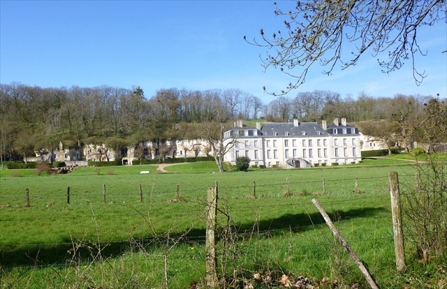 A 30 km au Nord-Est de Blois, le château de Rochambeau se trouve sur la commune de Thoré-la-Rochette. Une petite route monte en lacets sur le plateau calcaire et permet d’observer la craie et ses fossiles.
La craie affleure tout le long de l’allée de Rochambeau qui mène au Château dont la construction remonte au XVIème siècle.
La craie contient de nombreux fossile marins identifiables à l’œil nu. On y trouve notamment des fossiles d’huîtres, des coraux et des vers marins. Des caves et aménagements troglodytes sont visibles tout le long du parcours.
Aux coordonnées, l’affleurement permet d’observer plusieurs structures sédimentaires.
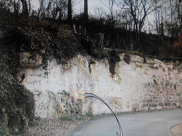 Des bancs calcaires séparés par des limites subhorizontales appelées ?.....? (ou hardground).
Des silex y sont souvent associés . Des fossiles marins avec une prédominance de .?., d’.?., et de .?. de bivalves.
Des puits karstiques dans la portion supérieure et le long de la route. La matrice de cette roche est de la craie friable blanchâtre parfois jaunâtre. Elle est localement parfois plus gréseuse.
Limites subhorizontales (hardground).
 La région Centre Val de Loire se trouve au cœur de la grande structure sédimentaire qu’est le Bassin de Paris. Plusieurs centaines de mètres de sédiments se superposent sous nos pieds et racontent l’histoire de la région depuis plus de 200 millions d’années.
A Thoré-la-Rochette, l’histoire locale est actuellement dictée par le Loir qui creuse son lit dans les formations rocheuses. Sur les flancs de ses longs méandres, on peut observer des roches qui se sont mises en place il y a plus de 80 MA*.
Cet âge correspond à un étage du .?. que l’on appelle le « .?. ». Au niveau de ce site, sur certaines zones, c’est une roche calcaire appelée Craie de Villedieu qui affleure.
FOSSILE - 1*Largeur = ?*************** FOSSILE - 2* Longueur= ?
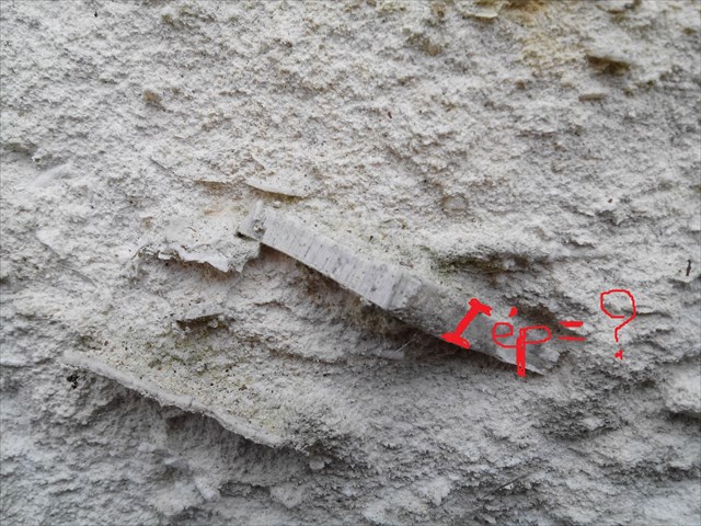
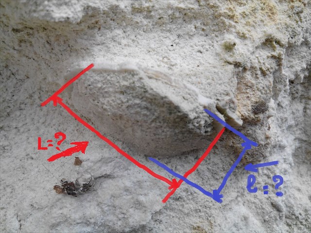
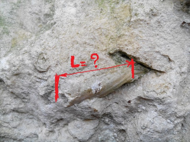 FOSSILE - 3* Epaisseur = ?***********FOSSILE - 4* Longueur et Largeur = ?
 RAPPEL: PAS DE BOITE A TROUVER !!!
POUR VALIDER LE FOUND IT: REPONDEZ AUX QUESTIONS SUIVANTES..
1) Etage et époque géologique de la falaise ?
RAPPEL: PAS DE BOITE A TROUVER !!!
POUR VALIDER LE FOUND IT: REPONDEZ AUX QUESTIONS SUIVANTES..
1) Etage et époque géologique de la falaise ?
2) Quest-ce que le "hardground" ?
3) Citez 3 fossiles marins présent dans ce calcaire ?
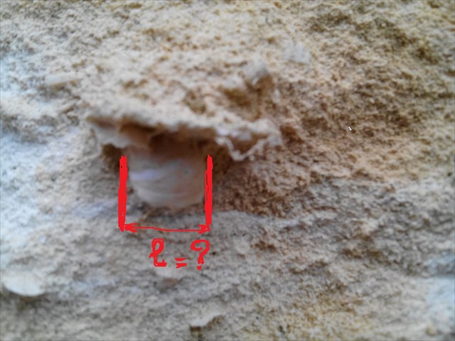
4) Recherchez les 4 fossiles en photos, et donnez leurs dimensions ?
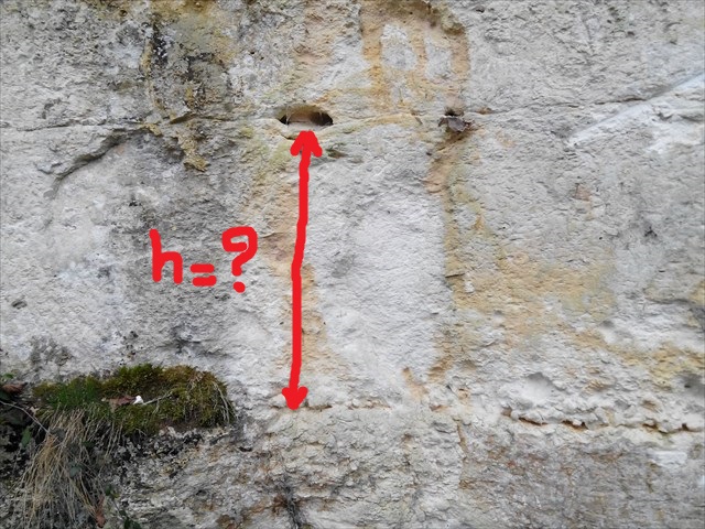
5) Mesurez la hauteur du "hardground" ?
6) Photo optionnelle de la falaise.
Loguez cette cache "Found it" et envoyez-moi vos propositions de réponses soit via mon profil, soit via la messagerie geocaching.com (Message Center), et je vous contacterai en cas de problème.
 The Rochambeau Fossil Chalk.
30 km north-east of Blois, the castle of Rochambeau is located in the town of Thoré-la-Rochette. A small road ascends in laces on the limestone plateau and allows to observe the chalk and its fossils.
The chalk rises along the Rochambeau path leading to the Chateau, which dates back to the 16th century. Chalk contains many marine fossils that can be identified with the naked eye. They include oyster fossils, corals and marine worms. Cellars and troglodyte facilities are visible all along the route.
At the coordinates, the outcrop allows to observe several sedimentary structures.
Calcareous beds separated by subhorizontal boundaries called? (Or hardground).
Flints are often associated with it. Marine fossils with a predominance of.,.,., And. Of bivalves.
Karstic wells in the upper portion and along the road. The matrix of this rock is whitish friable chalk sometimes yellowish. It is locally sometimes more sandy.
Subhorizontal boundaries (hardground).
The center of the Loire Valley is located in the heart of the large sedimentary structure of the Paris Basin. Several hundred meters of sediment are superimposed under our feet and tell the history of the region for more than 200 million years. In Thore-la-Rochette, the local history is currently dictated by the Loir which digs its bed in the rock formations. On the flanks of its long meanders, one can observe rocks that have been set up there are more than 80 MA *.
This age corresponds to a floor of the. Which is called the ". ". At this site, in certain areas, it is a limestone rock called Chalk of Villedieu that is outcropping.
FOSSILE - 1 * Width =? *************** FOSSILE - 2 * Length =?
/>  FOSSILE - 3 * Thickness =? *********** FOSSILE - 4 * Length and Width =?
 REMINDER: NO BOX TO FIND !!!
TO ENABLE THE FOUND IT: ANSWER THE FOLLOWING QUESTIONS.
1) Floor and geological time of the cliff?
REMINDER: NO BOX TO FIND !!!
TO ENABLE THE FOUND IT: ANSWER THE FOLLOWING QUESTIONS.
1) Floor and geological time of the cliff?
2) What is "hardground"?
3) Cite 3 marine fossils present in this limestone?
4) Look for the 4 fossils in photos, and give their dimensions?
5) Measure the height of the hardground?
6) Optional photo of the cliff.
Log in this "Found it" cache Message Center), and I will contact you in case of problem. Log in this "Found it" cache Message Center), and I will contact you in case of problem.
BELLE BALADE, JE VOUS ATTENDS/BEAUTIFUL WALKING, YOU WAIT 
Additional Hints
(Decrypt)
A'bhoyvrm cnf qr dhbv ceraqer yrf zrfherf !!!
********
Qb abg sbetrg gb gnxr zrnfherzragf !!!