Ghost Lake (FSf #1) Mystery Cache
-
Difficulty:
-

-
Terrain:
-

Size:  (regular)
Please note Use of geocaching.com services is subject to the terms and conditions
in our disclaimer.
My Forgotten Springfield series will take you to forgotten little corners of Springfield, revealing forgotten little bits of history. The series currently also includes award-nominated Abandoned Hooes Road, Cross County Expressway, and Crossroad Development.
 NoVAGO
Best Historical/Educational Cache
2017
NoVAGO
Best Historical/Educational Cache
2017
This cache is placed in Hunter Village Park in Springfield. The cache is not at the listed coordinates, but is where you should begin this adventure, which will take along the shores of a lake that has been gone and forgotten for decades. Along the way, you will collect some clues and perform some simple calculations, which will lead you to the cache's final location. This plays a bit like a multi-stage or letterbox. I've since added rough coordinates for some waypoints, but you probably won't need them. The roundtrip is about one mile.
At the park entrance at Jansen Drive (near its intersection with Harwood Place), there is a sign regarding illegal dumping. There are 10 digits on this sign. Add them up and let this equal A.
Take the path that runs south (downhill, to the right, behind the houses, along the natural gas pipeline). In a thousand feet or so, you will reach a crossroads of sorts. Note the manhole cover (MADE ININDIA). Continue straight, downhill, past the blue water main markers. The path will lead you to a narrow stream. Rockhopping across this stream is usually fairly simple (even for most elementary school kids) near the leaning tree (waypoint provided). Once on the other side, continue on the path upstream (northwest).
Very soon, you will see a fire hydrant with a "flexi-flag" attached to it. Closer examination of the flag reveals that its U.S. patent number has 7 digits. Add up these digits and let this equal B. Its Canadian patent number has 6 digits. Add them up and let this equal C.
(May 2019) The hydrant is now overgrown and difficult to access. Until this situation changes, I'll just provide you with the clues:
U.S. Pat. No. 3,044,435 => 23
Canada Pat. No 713,846 => 29
Continue on the path and take the left fork (toward a girthy, twelve-foot stump). The westerly path will bring you to the base of a relatively steep slope (waypoint provided). Up you go!
You are now standing atop an earthen dam, built around 1959, when the neighborhood to the immediate north was built. And down below you, to the northwest, was once a lake -- a few acres large. Here is an aerial photograph of the lake taken on April 13, 1960:
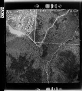
Here, is a close-up of the dam from 1960:
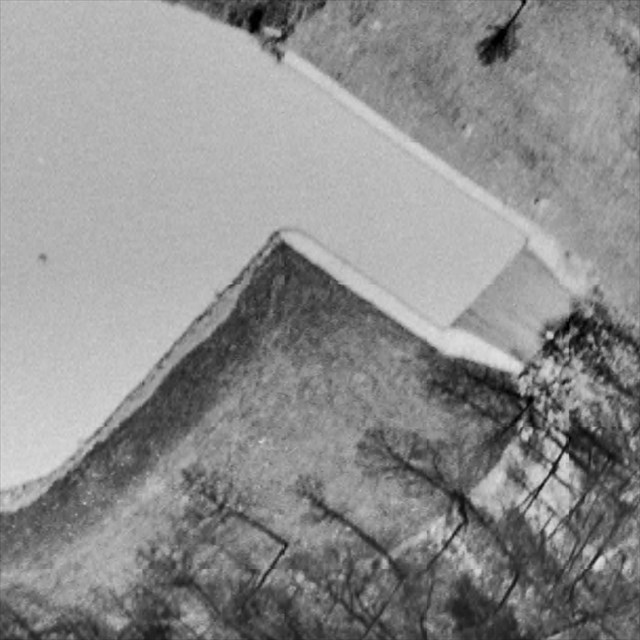
Note the apparent height of the dam in the above image. And the top of the tall manhole that you see rising from the lake bed can also be seen in this image.
Here, is an aerial photograph of the neighborhood from 1962:

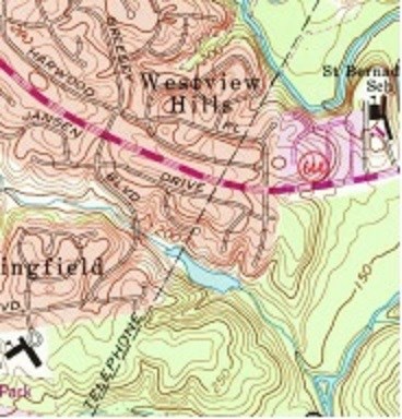
Here, it is depicted on a 1965 USGS topographical map:
By September 1970, the lake was gone (according to another aerial photograph), and it also soon disappeared from USGS topographical maps.
I don't know anymore than that, but I would love to hear from anyone who remembers this lake, whether it had a name (formal or informal), when exactly the northeastern segment of the dam was removed, the lake drained, the stream restored, and why.
UPDATE (February 2019): Thanks to a fellow geocacher and the I Remember in Springfield Virginia When… Facebook group, the story behind this lake has come to light, including a Washington Post article from May 10, 1971 titled Aftermath of a Broken Dam – Frustration: Lake Dwellers Who Lost Their Lake.
This lake indeed dates from around 1959. Eight acres and six feet deep, it was the third in a series of three unnamed lakes constructed along a tributary of Accotink Creek by noted local developer Edward Carr. The three lakes belonged to the Springfield Golf & Country Club. While the other two lakes were (and still are) integrated into the golf course itself and were used to water the course, this third lake was cut off from the rest of club’s property by Greeley Boulevard, served it no useful purpose, and therefore was apparently thoroughly neglected. The ground underneath the dam began to erode. Cracks and leaks formed in the dam. In June 1970, Fairfax County declared the lake a health and safety hazard. Besides the deteriorating dam, the county cited prolific mosquito breeding, polluted water, and excessive weed growth along the banks.
Then, on the dark and stormy night of July 9, 1970, “two severe thunderstorms built up water behind the deteriorating dam and it gave way, draining the lake.”
The following week, the club responded to the county: “We were in the process of taking action on the items of concern when nature took a hand during the night of July 9.” Two months later, the county wrote the club again to report that inspections “revealed no progress in relieving the mosquitos breeding problem. Nor has any action been taken toward removing the dangerous remains of the washed-out dam.” (Indeed, in early 1971, a boy broke his leg on the concrete rubble.)
But the Springfield Golf & Country Club was completely uninterested in repairing the dam and refilling the lake. They simply wanted to unload this 13 acre tract. It offered the property for free to the residents of the adjacent community, who had recently formed the Westspring Lake Conservation Association. However, the $20,000 to $75,000 price tag for repairing the dam proved too costly for the citizens to proceed with the offer. The Fairfax County Park Authority also declined to take the property because of the repair costs and “the difficulty in supervising recreational activities on the property.” (It now belongs to the Daventry Community Association.)
People who lived in the area in the 1960s still have fond memories of fishing and ice skating and sledding down “Suicide Hill” (the steep telephone easement on the north side of the lake).
Continue on the path to the west, which then turns to the northwest. You are walking on the shoreline path of the long-gone lake. You'll eventually reach a clearing. Note the fallen down telephone pole from the old Chesapeake & Potomac Telephone Company. (This was more upright when the cache was first published, with wires still attached.) For your last set of clues, I'll have you head a bit uphill (to the southwest) to the next (nearly horizontal) telephone pole (waypoint provided).
(August 2020) This telephone pole has now fallen down. The information you need is still accessible however, about seven feet from the now broken base end, and a few inches off the ground. You may now need cellphone photos to observe some of the necessary details. Sorry for the inconvenience.
This uphill telephone pole has an identification number that has 3 digits. Add up these digits and let this equal D. This same pole also has three inspection tags. The 2nd inspection took place in a year with 4 digits. Add up these digits and let this equal E. How many years elapsed between the 1st and 2nd inspection? Let this equal F.
You now have all the information you need to compute the cache's final location:
N 38° 46. ( (A-E) + (2*C*F) )
W 077° 12. (2*B*D)
You can use the Solution Checker (on the webpage) to check your answer.
Enjoy the walk back. There is a Swiss Bakery gift card for the FTF (congrats to Serrabou!) and some dollar-store goodies for the runners-up.
Additional Hints
(Decrypt)
Gur pnpur vf na nzzb pna ybpngrq va n pbzzba uvqvat fcbg, nobhg gjragl-svir cnprf bss bs n genvy.