The quaint village of Buckeystown, Maryland has changed little since the day the Confederate Army marched through on its way to Antietam in September 1862. As a matter of fact, it is listed on the National Register of Historic Places.
A stout Methodist Episcopal church was constructed along Buckeystown Pike in 1827. The services were open to both whites and blacks, but the congregation disbanded around the time of the Civil war, when a minister with Northern sympathies was appointed. Eventually, the building was abandoned and then demolished. The stones were used for the foundations of nearby homes.
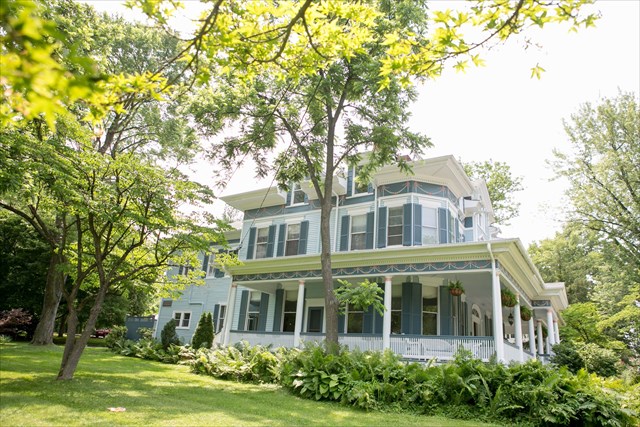
A mansion was constructed on the property in 1897 by Charles E. Keller. He was the owner of a nearby limestone quarry. The house was built in the style of a Colonial Revival. It is said that it was patterned after a residence that Keller had observed in Rockville.
The Keller family remained in the home until 1938. After that time, the house went through multiple owners and several stages until it was converted in 1981 to a bed and breakfast, which it still is today.
The Geocache
This geocache is a three stage mutli-cache. At the given coordinates, you will find an information sign right along Buckeystown Pike. Use this sign to gather information which will help you figure out the coordinates to Stage 2. Use the left section of the sign to get the coordinates for North and the right section of the sign to get the coordinates for West.
Stage 1
- A = The second digit in the first line of text.
- B = The fourth digit of date in second line of text.
- C = First word of fifth line of text (It is a number).
- D = 1st number given in church dimensions minus 25.
- E = 2nd number given is church dimensions minus 39.
- F = # of benches placed in center plus 2.
The coordinates for Stage 2 are N39° 19.ABC, W77° 25.DEF
The checksum of ABCDEF is 42.
You will also need to discover four words that will help at Stage 2. You will be using the sentence at the bottom of the sign containing 5 words and a date to reveal the four words. Two of the letters have been provided for you.
Word #1
- ___ = 1st word 7th letter
- ___ = 4th word 8th letter
- ___ = 4th word 7th letter
- ___ = 5th word 4th letter
- ___ = 1st word 7th letter
Word #2
- ___ = 1st word 7th letter
- ___ = 3rd word 2nd letter
- ___ = 5th word 6th letter
- ___ = 1st word 2nd letter
- ___ = 4th word 11th letter
- ___ = 3rd word 10th letter
Word #3
- ___ = 5th word 3rd letter
- ___ = 4th word 8th letter
- ___ = 1st word 5th letter
- _H_
- ___ = 4th word 3rd letter
- ___ = 4th word 2nd letter
- ___ = 5th word 4th letter
- ___ = 3rd word last letter
- ___ = 4th word 3rd letter
Word #4
- _F_
- ___ = 1st word 2nd letter
- ___ = 5th word 4th letter
- ___ = 1st word last letter
- ___ = 4th word 8th letter
- ___ = 2nd word 2nd letter
Once at Stage 2, look for an object containing the first two words which will be used to find the north coordinates (G, H, and J), to the final location, and use an object containing words three and four which will be used to find the west coordinates (K, L, and M), to the final location.
Stage 2
- G = 4th number listed minus 2.
- H = 5th number listed minus 8.
- J = Date of death minus 22.
- K = Month died minus 3.
- L = Date of death.
- M = 3rd digit of year of death minus 4.
The geocache is located at N39° 19.GHJ, W77° 25.KLM
The checksum of GHJKLM is 33.
The following geocache has been approved by the property owner. Please park at the parking coordinates and not on Buckeystown Pike. The cache is available from sunup to sundown. If you wish to get a tour of the building or learn more about the history of Buckeystown, feel free to inquire at the inn. I would like to thank Buckeystown historian Nancy Bodmer for providing historical information and the owners of the property for allowing stages of the geocache to be on their property.