
A origem e evolução do sistema de ilhas barreira, como é o caso da Ria Formosa, está relacionada com variações relativas do nível do mar resultantes, principalmente, das glaciações e deglaciações. Quando o nível do mar estava próximo do bordo da plataforma (há cerca de 18000 anos) formaram-se cordões arenosos (beach-ridges) paralelos à costa. Com a posterior subida do nível do mar, estes cordões arenosos foram inundados pelo lado do continente, formando ilhas paralelas à costa. Depois de formadas, as ilhas responderam à progressiva subida do nível marinho com um conjunto de processos de que resultou a sua migração transversal através da plataforma continental.
The origin and evolution of the system of barrier islands, such as the one of Ria Formosa, is related to the variations of the sea level resulting mainly from glaciations and deglaciations. When the sea level was near the platform edge (about 18000 years ago), beach-ridges parallel to the coast were formed. With the subsequent rise of the sea level, these sandy cords were flooded by the continent sideway forming parallel islands to the coast. After its forming, the islands responded to the progressive rise of the sea level resulting in their transverse migration along the continental shelf.

O sistema barreira da Ria Formosa é constituído por uma série de penínsulas e ilhas que delimitam um ambiente lagunar interior. De oeste para leste encontram-se a Península do Ancão, as ilhas da Barreta, da Culatra, da Armona, de Tavira e de Cabanas e a Península de Cacela. Cada uma destas ilhas (e penínsulas) apresenta características particulares. Os processos destrutivos e construtivos (tais como galgamentos oceânicos (overwashes), vegetação, cortes eólicos (blow-outs), canais de maré, " sand flats" e deltas de enchente e vazante) atuam de forma diferenciada em cada ilha, conferindo-lhes aspetos específicos.
The barrier system of the Ria Formosa is formed by two spits and several islands which limit an interior lagoon. From west to east, there are the Ancão spits, the Barreta, Culatra, Armona, Tavira and Cabanas Islands and the Cacela spits can be found. Each of these islands (and spits) has specific characteristics. Destructive and constructive processes (such as overwashes, vegetation, blow-outs, tidal channels, sand flats, and flood deltas and ebb) act differently on each island, giving them singular aspects.
Península do Ancão
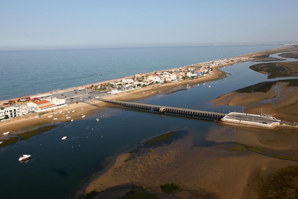
A Península do Ancão é comprida e estreita (cerca de 10 km de comprimento e 100 a 20 m de largura), dispondo-se segundo a direção NW-SE. Podem considerar-se, nesta Península, três sectores:
- a) Do "enraizamento" à zona urbanizada a duna é elevada (sendo a altura frequentemente superior a 10m), observando-se vestígios de galgamentos oceânicos (overwashes), por vezes muito importantes (que chegam a atingir mais de 35m de largura e interrompem completamente o cordão dunar). Os cortes eólicos (blow-outs) originados por pisoteio são numerosos, o que evidencia intensa ocupação humana desordenada.
- b) O sector urbanizado (conhecido pelo nome de praia de Faro), constitui a parte central da Península, e é o único local do sistema facilmente acessível com automóvel (através da ponte). O cordão dunar está totalmente destruído. A construção (maioritariamente clandestina) é completamente desordenada. Em período de marés-vivas cheias, as águas chegam a atingir as casas, nomeadamente na parte junto à laguna (esteiro do Ancão). Em período de tempestades verificam-se, com frequência, danos na muralha que limita e protege o largo fronteiro à ponte, bem como inundações de arruamentos e habitações. Como índice da fragilidade desta ilha pode referir-se, por exemplo, que no decurso da tempestade de 20/21 de Fevereiro de 1966 se verificou galgamento oceânico em onze locais, devido a vagas provenientes de SW e SSW;
- c) Entre a parte urbanizada e a barra do Ancão o cordão dunar é estreito e pouco elevado, acabando por desaparecer junto à extremidade SE, correspondendo à zona de migração desta barra, para oriente, no século passado.
The Ancão spits is long and narrow (about 10 km long and 100 to 20 m wide), and is located in the NW-SE direction. Three sectors can be considered in this spits:
- A) From the "rooting" to the urbanized zone the dune is high (the height is frequently more than 10m), being observed remains of overwashes, occasionally very important (which can reach more than 35m wide and completely interrupting the dune string). The blow-outs caused by trampling are numerous, which evidences an intense disordered human occupation;
- B) The urbanized sector (known as the Faro beach) holds the central part of the spits, and is the only place of the system that ca be easily reached by car (through the bridge). The dune string is totally destroyed. The construction (mostly clandestine) is completely disorderly. In the spring tides (highest spring tides), the waters usually reach the houses, namely near the the lagoon (Ancão estuary). Often damage in the wall that limits and protects the square near the bridge can occur during storms, as well as street floods. The fragility of this island could be demonstrated by the occurrences during the storm of 20/21 February 1966, when sea beds in eleven locations took place, due to waves from SW and SSW;
- C) Between the urbanized part and the tidal inlet of Ancão the dune is narrow and not very high, disappearing next to the SE end, corresponding to the migration zone of this tidal inlet to the east during the past century.
A Barra do Ancão efetua a separação entre a Península do Ancão e a Ilha da Barreta. A tendência natural desta barra é a de migrar de ocidente para oriente, até uma posição limite, localizada aproximadamente onde atualmente se situa, verificando-se, então, o seu assoreamento e abertura de nova barra a ocidente, na zona localizada frente à Quinta do Lago. Esta barra parece ter atingido certa estabilidade, visto que a sua evolução tem sido muito pequena desde 1966. É provável que, se não fosse a intervenção humana no sistema, esta barra estivesse já fechada e se tivesse aberto nova barra a oeste.
The Ancão tidal inlet splits the Ancão spits from the Barreta Island. Usually, this tidal inlet tends to migrate from west to east, to a boundary position, located near the current location. In a subsequent phase tend to silt and a new tidal inlet can appear in the west side, in front of Quinta do Lake. However, this tidal inlet presents a current stability since its evolution has been very slight since 1966. This fact is probably derived by the anthropic action in the system. Without that this tidal inlet would be closed and a new tidal inlet had been opened at the west side.
Para “logar” esta cache deve visitar o local, nas coordenadas indicadas.
To "log in" this cache you should visit the place, in the indicated coordinates.
Deve depois responder às seguintes questões e enviar as respostas utilizando o botão "Message this owner" presente no cimo desta página.
Then you should answer the following questions and send the answers using "Message this owner".
1 - Explique por palavras suas como se formou a Ria Formosa.
1 - Describe in your own words how the Ria Formosa was formed.
2 - Qual a dimensão da Península em que se encontra?
2 - Which size presents the spits where you are?
3 - Estime a altura da duna no GZ. (O GPS pode ajudá-lo!)?
3 - Estimate the height of the dune in the GZ. (the GPS can help you!)?
(Opcional) Tire uma foto de com algo que o identifique como geocacher no local!
(Optional) On the spot take a picture with something that recognizes you as a geocacher!
Em seguida poderá fazer o seu “found it” online!
Then you can do your "found it" online!