Nemrut volcano EarthCache
-
Difficulty:
-

-
Terrain:
-

Size:  (other)
Please note Use of geocaching.com services is subject to the terms and conditions
in our disclaimer.

Nemrut (Turkish: Nemrut Dağı, Armenian: Սարակն Sarakn, "Mountain spring", Armenian pronunciation: [sɑˈɾɑkən], Kurdish: Çiyayê Nemrud) is a dormant volcano in Eastern Turkey, close to Lake Van. The volcano is named after King Nimrod who is said to have ruled this area in about 2100 BC. Elevation is 2,948 ~ 3300 m.
Nemrut is a polygenic stratovolcano located in the collision zone of the Arabian and Eurasian tectonic plates, which determines the seismic and volcanic activity in the region. The collision of these plates began in the Middle Eocene and closed the stretch of water, which in the Mesozoic formed the Tethys Ocean. Nemrut, along with three other extinct volcanoes of eastern Turkey: Ararat, Tendürek and Süphan, is located in the area of a complex fault, which runs along the boundary of the Arabian and Eurasian plates in the territory of the Armenian Highland. It is the westernmost of these volcanoes, the only one that remains active, and generally the only volcano in Anatolia, which erupted in the historical period. Nemrut is located 10 km north of the city Tatvan, in the north-western shore of Lake Van.
Nemrut was probably formed in the early Quaternary Period, about 1 million years ago. It showed the greatest activity in the Pleistocene, with regular eruptions occurring in the Holocene. In the middle Pleistocene, about 250,000 years ago, a major eruption formed a lava flow over 60 km long, which blocked the water discharge from the Van basin and formed Lake Van, the world's largest alkali endorheic lake. In the same period, the conical top of the volcano collapsed inward, forming an 8.3×7 km caldera. Later, the freshwater Lake Nemrut formed inside the caldera, becoming the world's second largest caldera lake. Subsequent eruptions separated a small lake Ilı from Lake Nemrut. Has an elliptical shape, its size at the base is 27×18 km, and its center contains 377.5 km3 of volcanic materials. The caldera of Nemrut is the largest in Turkey, the fourth largest in Europe and sixteenth largest in the world.
Caldera and its types
A caldera is a large cauldron-like depression that forms following the evacuation of a magma chamber/reservoir. When large volumes of magma are erupted over a short time period structural support for the crust above the magma chamber is lost. The ground surface then collapses downward into the partially emptied magma chamber, leaving a massive depression at the surface (from one to dozens of kilometers in diameter). Although sometimes described as a crater, the feature is actually a type of sinkhole, as it is formed through subsidence and collapse rather than an explosion or impact. Only seven known caldera-forming collapses have occurred since the start of the 20th century, most recently at Bárðarbunga volcano in Iceland.
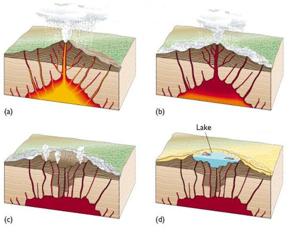
Explosive
If the magma is rich in silica, the caldera is often filled in with ignimbrite, tuff, rhyolite, and other igneous rocks. Silica-rich magma has a high viscosity, and therefore does not flow easily like basalt. As a result, gases tend to become trapped at high pressure within the magma. When the magma approaches the surface of the Earth, the rapid off-loading of overlying material causes the trapped gases to decompress rapidly, thus triggering explosive destruction of the magma and spreading volcanic ash over wide areas. Further lava flows may be erupted.
If volcanic activity continues, the center of the caldera may be uplifted in the form of a resurgent dome such as is seen at Cerro Galán, Lake Toba, Yellowstone, etc., by subsequent intrusion of magma. A silicic or rhyolitic caldera may erupt hundreds or even thousands of cubic kilometers of material in a single event. Even small caldera-forming eruptions, such as Krakatoa in 1883 or Mount Pinatubo in 1991, may result in significant local destruction and a noticeable drop in temperature around the world. Large calderas may have even greater effects.
Non-explosive
The magma feeding these volcanoes is basalt which is silica poor. As a result, the magma is much less viscous than the magma of a rhyolitic volcano, and the magma chamber is drained by large lava flows rather than by explosive events. The resulting calderas are also known as subsidence calderas, and can form more gradually than explosive calderas. For instance, the caldera atop Fernandina Island underwent a collapse in 1968, when parts of the caldera floor dropped 350 meters.
Lakes
Lake Nemrut (Turkish: Nemrut gölü) is located in the south-western part of the caldera and is now a freshwater lake. Similar to Lake Van, under the influence of volcanic processes it is gradually becoming a saline lake. The lake is fed by hot springs, which is why it is warmer at the bottom than at the surface and does not freeze in winter. The total area is 4.9×2.1 km, the average depth is 140 m, and the maximum depth is 176 m; the altitude of the lake is 2,247 m (7,372 ft) above the sea level.
For Example: water in the lake Nemrut is slightly alkaline, thus similar water how in Lake Van. Tap water has a pH factor of about 6,5 ~ 8,5. But water in lake Van have ph factor of about 8 ~10,5.

Lake Ilı (Turkish: Ilı gölü, "hot lake") was split from Lake Nemrut by an ancient lava flow. Ilı is located closer to the fault than Lake Nemrut; therefore it has a larger inflow of hot springs and a higher temperature. In the summer, it sometimes reaches 60 °C, and an average is 6–8 °C warmer than expected for a lake of its altitude. Nevertheless, it partly freezes in winter because of the small size and depth.
Volcanic activity
Last known historical activity of the volcano was in 1692, 1587 and 1441. In the 1980s, Japanese volcanologists studied the evolution of gases inside the caldera of Nemrut. They found that the ratio of helium isotopes 3He/4He is 1.06×10⁻⁵, which indicates volcanic activity (most of the measured helium evolved from the mantle). More recent studies have confirmed these findings. The seismic activity in the region is high – in recent years there have been several earthquakes directly related to the Nemrut fault. Significant seismic events of the last 150 years that occurred within 30 km of Nemrut include the earthquakes of 18 May 1881 (magnitude 6.7), 29 March 1907 (magnitude 5), 27 January 1913 (magnitude 5), 14 February 1915 (magnitude 6), and 3 November 1997 (magnitude 5).
There is evidence that the nature of volcanism in the region may change due to the shift of stress at the boundary of the Arabian and Eurasian plates. The direction of pressure coming from the Arabian plate is gradually turning from South-North to the West-East, with a linear shift of 7.8–9 mm per year. Fumarolic activity and the presence of many hot springs are observed at the bottom of the caldera.
Recent studies note the danger of possible eruptions. Nemrut is located in close proximity to Tatvan (distance 10 km, population: 66,000), Bitlis (population 52,000), Ahlat (population 22,000), and a number of smaller settlements. In total, about 135,000 people live in the potential eruption zone. The presence of more than 1 km3 of water in the caldera adds a risk of flooding, which may destroy Güroymak, a town of 15,000 people.
Requirements for log
1) Measuring the pH value of water in the lake Nemrut and in the lake Ilı. Ph papers bought in every drug store.
2) Why the measured values are so different?
3) What causes different color lakes?
4) What kind Calder exists here?
I would be glad if you send me your photo of the place.
Nemrut Dağı, Doğu Anadolu'da Van gölü yakınında durgun bir volkandır. Volkan, M.Ö. 2100 yıllarında bu bölgeyi yönettiği söylenen Kral Nimrod'ın adını almıştır. Yükseklik 2,948 ~ 3300 m'dir.
Nemrut, bölgedeki sismik ve volkanik aktiviteyi belirleyen Arap ve Avrasya tektonik plakalarının çarpışma bölgesinde bulunan polijenik bir stratovolkanadır. Bu plakaların çarpışması Orta Eosen'de başlamış ve Mesozoikte Tetis Okyanusu'nu oluşturan suyun gerginliğini kapatmıştır. Nemrut, doğu Türkiye'deki üç ölü yanardağla birlikte: Ararat, Tendürek ve Süphan, Ermeni Yaylası topraklarındaki Arap ve Avrasya levhalarının sınırları boyunca uzanan karmaşık bir fay alanında yer almaktadır. Bu volkanın en batısındaki, aktif olan tek volkandır ve genellikle tarihî dönemde patlak veren Anadolu'daki tek yanardondur. Nemrut, Van Gölü'nün kuzeybatısındaki Tatvan kentinin 10 km kuzeyinde yer almaktadır.
Nemrut muhtemelen yaklaşık 1 milyon yıl önce erken Kuvaterner Döneminde kurulmuştur. Pleistosen'de, Holosen'de düzenli patlamalar meydana gelen en büyük etkinliği gösterdi. Yaklaşık 250.000 yıl önce ortadaki Pleistosen'de büyük bir patlama, 60 km uzunluğunda bir lav akışı oluşturdu ve Van havzasındaki suyun boşaltılmasını engelledi ve dünyanın en büyük alkali endorheik gölü olan Van Gölü'nü kurdu. Aynı dönemde, yanardağın konik tepesi 8.3 × 7 km kaldera oluşturarak içe doğru çöktü. Daha sonra, tatlısu Nemrut, kalderada oluştu ve dünyanın ikinci büyük kaldera gölü oldu. Daha sonraki patlamalar, Ilı'nın küçük bir gölünü Nemrut Gölü'nden ayırdı. Eliptik bir şekle sahiptir, tabandaki boyutu 27 × 18 km'dir ve merkezi 377.5 km3'lük volkanik materyal içerir. Nemrut'un kalderası Türkiye'nin en büyük, Avrupa'nın en büyük dördüncü, dünyanın en büyük on altı.
Kaldera ve çeşitleri
Bir kaldera, bir magma odası / haznesinin tahliyesini takiben oluşan geniş bir kazan gibi depresyondur. Kısa sürede büyük miktarlarda magma patladığında, magma odasının üstündeki kabuğa yapısal destek kaybedilir. Zemin yüzeyi aşağıya doğru kısmen boşalan magma odasına çöker ve yüzeyde büyük çapta bir çöküntü bırakır (çaptan bir düzinedençine kadar). Bazen bir krater olarak tanımlansa da, bir patlama veya darbe yerine çökme ve çökme yoluyla oluştuğu için bu özellik aslında bir düdük deliğidir. 20. yüzyılın başından beri, en son İzlanda'daki Bárðbbunga volkanında bilinen yedi kaldera oluşumu çöktü.
Patlayıcı
Eğer magma silisyumdan zenginse, kaldera genellikle ignimbrite, tüf, riyolit ve diğer magmatik kayaçlarla doldurulur. Silika bakımından zengin magma, yüksek viskoziteye sahiptir ve bu nedenle kolayca bazalt gibi akmaz. Sonuç olarak, gazlar magma içindeki yüksek basınçta sıkışan olma eğilimindedir. Magma, Dünya'nın yüzeyine yaklaştığında üstteki materyalin hızlı bir şekilde boşaltılması, sıkışan gazların hızla dekompresyona uğramasına neden olur; böylece magmanın patlayarak tahrip edilmesini ve volkanik küllerin geniş alanlara yayılması sağlanır. Daha fazla lav akışı patlayabilir.
Volkanik aktivite devam ederse, kalderanın merkezi Cerro Galán, Toba Gölü, Yellowstone vb. Gibi daha sonraki magma saldırısı ile görülen gibi dirilen bir kubbe biçiminde yükseltilebilir. Bir silik ya da riyolitik kaldera tek bir olayda yüzlerce ya da binlerce kübik kilometre malzeme patlayabilir. 1883'te Krakatoa ya da 1991'de Pinatubo Dağı gibi küçük kaldera oluşturan patlamalar bile, önemli ölçüde yerel tahribata ve dünyanın her yerinde sıcaklıkta gözle görülür bir düşüşe neden olabilir. Büyük kalderaların daha da fazla etkileri olabilir.
Patlayıcı olmayan
Bu volkanlara besleyen magma silisyum zayıf bazalttır. Sonuç olarak, magma, riyolitik bir yanardağın magmadan daha az viskozdur ve magma odası, patlayıcı olaylardan çok, büyük lav akıntılarıyla süzülmüştür. Ortaya çıkan kalderalar, çökme kalderaları olarak da bilinir ve patlayıcı kalderalara göre daha yavaş form oluşturabilir. Örneğin, Fernandina Adası'nın üstündeki kaldera, 1968'de kalderanın zemininin bir kısmı 350 metre düştüğünde çöktü.
Göller
Nemrut Gölü, kalderanın güneybatısındadır ve şimdi tatlı su gölüdür. Van Gölü benzeri, volkanik süreçlerin etkisi altında yavaş yavaş bir tuzlu göl haline gelmektedir. Göl, kaplıcalarla beslenmektedir, bu yüzden yüzeye kıyasla alt kısımda daha sıcaktır ve kışın donmaz. Toplam alan 4.9 × 2.1 km, ortalama derinlik 140 m ve maksimum derinlik 176 m; Gölün yüksekliği deniz seviyesinden 2.247 m (735 ft) yukarıda.
Örneğin: Nemrut gölündeki su hafifçe alkalindir, dolayısıyla Van Gölü'nde nasıl benzer su var. Musluk suyu yaklaşık 6,5 ~ 8,5 pH faktörüne sahiptir. Ancak Van gölü suyunun pH değeri yaklaşık 8 ~ 10,5'dir.
Ilı Göl, eski bir lav akışı ile Nemrut Gölü'nden ayrılmıştır. Ilı, Nemrut Gölü'nden daha arıza yakınında; Bu nedenle daha büyük bir sıcak su kaynağına ve daha yüksek bir sıcaklığa sahiptir. Yaz aylarında bazen 60 ° C'ye ulaşıyor ve ortalama yüksekliğindeki bir gölde beklenenden 6-8 ° C daha sıcaktır. Bununla birlikte, küçük boyut ve derinlik nedeniyle kışın kısmen donar.
Volkanik aktivite
Volkanın bilinen son tarihi olayı 1692, 1587 ve 1441 yıllarıydı. 1980'lerde Japon volkanologlar Nemrut kalderasında gazların evrimini inceledi. Onlar, helyum izotoplarının 3He / 4He oranının 1.06 × 10⁻⁵ olduğunu ve bu da volkanik aktiviteyi (ölçülen helyumun çoğunun mantoldan evrimleştiğini) belirledi. Daha yeni çalışmalar bu bulguları doğrulamıştır. Bölgedeki deprem etkinliği yüksek - son yıllarda doğrudan doğruya Nemrut fayı ile ilgili birkaç deprem meydana geldi. Nemrut'un 30 km'inde meydana gelen son 150 yıldaki önemli sismik olaylar arasında, 18 Mayıs 1881 (magnitüd 6.7), 29 Mart 1907 (büyüklük 5), 27 Ocak 1913 (büyüklük 5), 14 Şubat 1915 (büyüklük 6) depremleri, , Ve 3 Kasım 1997 (büyüklük 5).
Bölgedeki volkanizmanın doğasının, Arap ve Avrasya plakalarının sınırındaki stresin kayması nedeniyle değişebileceğine dair kanıtlar vardır. Arap plakasından gelen basınç yönü, Güney-Kuzey'den Batı-Doğu'ya kademeli olarak dönüyor ve yılda 7.8-9 mm doğrusal bir kayma var. Kalderanın alt kısmında fumarolik aktivite ve birçok kaplıcanın varlığı görülür.
Son zamanlarda yapılan çalışmalar olası patlamalar tehlikesine dikkat çekti. Nemrut, Tatvan'a (10 km uzaklıktaki, 66.000 nüfuslu), Bitlis'e (52.000 nüfusa), Ahlat'a (22.000 nüfusa) ve daha küçük yerleşim yerlerine çok yakındır. Toplamda potansiyel patlama bölgesinde yaklaşık 135.000 kişi yaşıyor. Kaldera'da 1 km3'ten fazla su varlığı, 15.000 kişilik bir kasaba olan Güroymak'ı tahrip edebilecek bir su baskını riski katmaktadır.
Kayıt gereksinimleri
1) Nemrut gölündeki ve Ilı göldeki suyun pH değerinin ölçülmesi. Ph uyuşturucu dükkanında satın aldı.
2) Ölçülen değerler neden bu kadar farklı?
3) Farklı renk göllerine neden olan nedir?
4) Calder burada ne çeşit var?
Bana odanın fotoğrafını gönderirsen memnun olurum.
Additional Hints
(No hints available.)