La Earhcache / The Earhcache
A Saint Briac, l'îlot de la Dame Jouanne est connu pour son petit massif de leucogranite au coeur de la migmatite.
Partons à la découverte de cette roche plutonique disposée au sein d'un petit diapir très proche de sa base, et qui est le témoin visible de l'ultime stade de formation de la chaîne cadomienne.
► L'orogenèse cadomienne
L'orogène cadomienne, ou formation de la chaîne de montagne cadomienne s'est réalisé il y a 550 millions d'années, sous l'effet de la subduction du plancher océanique sous le supercontinent Gondwana.
Cette chaîne de montagne s'est formé dans une orientation nord-est / sud-ouest.
Les restes de cette formation aujourd'hui érodée constituent la partie Nord-Est du massif armoricain, ainsi que les zones du Cotentin et de la région de Caen (dont elle tire le nom).
Elle a été le théâtre d'un métamorphisme, c'est à dire la transformation de la roche sous l'action de la température et de la pression.
Sous l'élévation de cette température, les roches pré-existantes (des couches sédimentaires schisteuses et gréseuses briovériennes) se sont métamorphisées selon un gradiant principalement températures donnant un ensemble, le domaine métamorphique de Saint-Malo-Dinan.
D'un point de vue synthétique, se succèdent 3 ensembles dans un suite continue de métamorphisme croissant en haute température / basse pression :

- un ensemble à dominante micaschisteuse connu sous le nom de micaschistes de Langrolay-Saint-Suliac. Il s'agit de roches plutôt sombres avec un litage fort.
- un ensemble à dominante gneissique connu sous le nom de gneiss de la vallée de la Rance, Il s'agit de roches à grains plus fins et de couleur plutôt gris claire.

- un ensemble à dominante migmatique connu sous le nom de migmatites de Saint-Malo avec en son cœur un diapir de leucogranite, que nous allons détaillé plus loin.
En géologie, un diapir est un type d'intrusion impliquant une structure plus ou moins globuleuse, résultant de la remontée de roches plus légères à travers des roches plus denses.
C'est l'érosion qui a pu mettre à jour les différentes formations, qui ont subis des mouvements tectoniques de plissement importants, et notamment ce diapir de leucogranite. Voici les couches de la carte principale en coupe transversale.

► Les roches de la Dame Jouanne
Nous nous trouvons ici au cœur de la chaîne cadomienne, la partie la plus avancée en terme de température ou le solide a fait place au liquide, donnant des roches caractéristiques.

Selon le stade de fusion, nous avons :
- Des Métatexites : migmatites d'aspect hétérogène, dans lesquelles de larges structures n'ont pas subi de fusion. Ces blocs de roches non fondues correspondent au stade métamorphique précédent, ici du gneiss gris.

- Des Diatexites : migmatites d'aspect hétérogène, mais ou la partie fusionnée est prépondérante. On observe cependant un litage, une foliation des minéraux. Cette roche est encore anisotrope (orientée).

- Du Leucogranite : stade ultime de ce gradiant de température causant une fusion complète de la roche formant un pluton granitique au cœur de l'île de la Dame Jouanne. Cette roche est un granite clair, à gros grains et complètement isotrope (non orientée).
Elle est aussi qualifiée de granite d'anatexie car issue de la fusion de la roche environnante.

In Saint Briac, the islet of the Dame Jouanne is known for its small mass of leucogranite in the heart of the migmatite.
Let us begin with the discovery of this plutonic rock disposed within a small diapir very close to its base and which is the visible witness of the ultimate stage of formation of the Cadomian chain.
► The Cadomian Orogen
The cadomian orogen, or formation of the cadomian mountain chain, occurred 550 million years ago, under the effect of the subduction of the ocean floor under the supercontinent Gondwana.
This mountain range was formed in a north-east / south-west orientation.
The remains of this now eroded formation constitute the northeastern part of the Armorican massif, as well as the areas of the Cotentin and the Caen region (which it takes the name).
It was the theater of a metamorphism, that is to say the transformation of rock under the action of temperature and pressure.
Under the elevation of this temperature, the pre-existing rocks (sedimentary schistous and sandy brierian layers) metamorphosed according to a gradient mainly temperatures giving an ensemble, the metamorphic domain of Saint-Malo-Dinan.
From a synthetic point of view, three sets follow one another in a continuous sequence of metamorphism increasing in high temperature / low pressure:
- a predominantly micaschisteous group known as microlisers of Langrolay-Saint-Suliac. These are rather dark rocks with a strong bed.
- a predominantly gneissic group known as gneiss of the Rance valley. They are fine grained rocks and rather light gray in color.
- a predominantly migmatic group known as the migmatites of Saint-Malo with in its heart a leucogranite diapir, which we will detail below.
In geology, a diapir is a type of intrusion involving a more or less globular structure, resulting from the rise of lighter rocks through denser rocks.
It is the erosion that has brought to light the different formations, which have undergone major tectonic movements of folding, and in particular this diapir of leucogranite. Here are the layers of the main map in cross section.
► The rocks of the Lady Jouanne
We find ourselves here at the heart of the Cadomian chain, the most advanced part in terms of temperature or the solid has given place to the liquid, giving characteristic rocks.
Depending on the stage of fusion, we have:
- Metatoxites: Migmatites of heterogeneous appearance, in which large structures have not undergone fusion. These blocks of unfused rocks correspond to the previous metamorphic stage, here gray gneiss.
- Diatexites: migmatites of heterogeneous aspect, but where the fused part is preponderant. There is however a bedding, a foliation of the minerals. This rock is still anisotropic (oriented).
- Leucogranite: the ultimate stage of this temperature gradient causing a complete melting of the rock forming a granite pluton in the heart of the island of la Dame Jouanne. This rock is a light granite, coarse grained and completely isotropic (non-oriented).
It is also called granite anatexia as a result of the fusion of the surrounding rock.
► Sources bibliographiques / Bibliographical sources
Les Questions / The Questions
!!! ATTENTION CACHE UNIQUEMENT ACCESSIBLE MAREE BASSE !!!
!!! WARNING EARTHCACHE ONLY ACCESSIBLE LOW TIDE !!!
Avant de vous y aventurer, consulter l'horaire des marées :
Before you go, check the tide schedule:
Horaires des marées à Saint-Briac-sur-Mer.
La lecture attentive du descriptif de la cache, ainsi qu'une observation des éléments de terrain et un peu de déduction sont normalement suffisants pour répondre aux questions de cette EarthCache.
A careful reading of the description of the cache, as well as observation of terrain features and some deduction is usually sufficient to answer questions of this EarthCache.
Questions pour valider :"Orogenèse Cadomienne à la Dame Jouanne"
Questions to validate: "Rance, a maritime river current"
Point 1 : N 48° 38.065 W 002° 08.367
Vous vous trouvez devant l'entrée du petit fortin sur l'île de la Dame Jouanne. Vous y trouvez un panneau présentant l'orogenèse cadomienne puis hercynienne (zone A) et un affleurement de roche (zone B) - voir photo WP1.
You are in front of the entrance of the little fort on the island of la Dame Jouanne. Here you will find a panel showing cadomian and then Hercynian orogeny (zone A) and a rock outcrop (zone B) - see photo WP1.
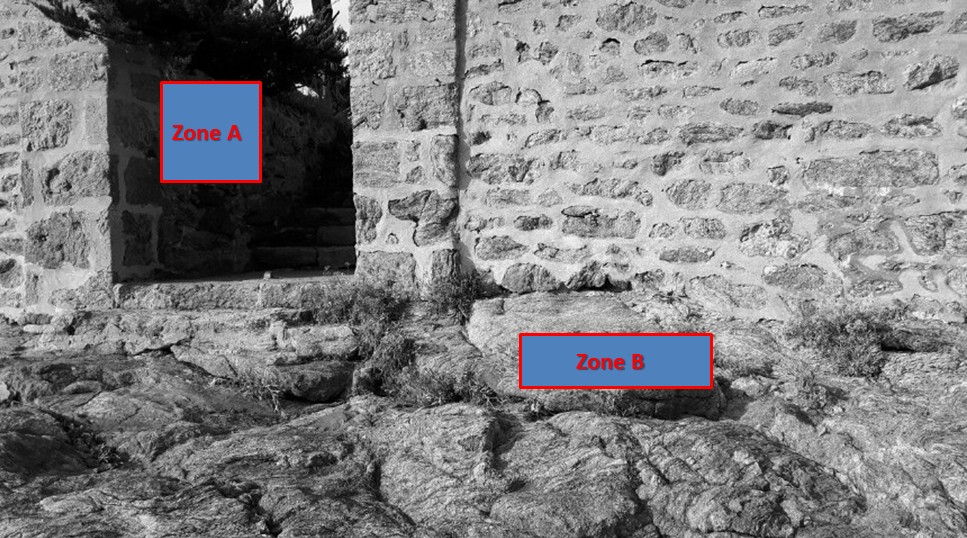
- Question 1 : Selon le panneau explicatif, quelle roche s'est insérée dans les fractures causées par l'orogenèse hercynienne dans l'encaissant cadomien ?
- Question 1: According to the explanatory panel, which rock entered the fractures caused by the Hercynian orogeny in the Cadomian enclosure?
- Question 2 : Comparer les photos du panneau avec la zone B. Est-ce la photo de gauche ou de droite ? Quelle est son stade de fusion ?
- Question 2 : Compare the photos of the panel with the area B. Is the picture left or right? What is its fusion stage?
- Question 3 : Mesurer la longueur de la trame gneissique de la zone B.
- Question 3 : Measure the length of the gneiss grid of zone B.
Point 2 : N 48° 38.058 W 002° 08.395
Observer la zone rouge de la photo WP2.
Observe the red area of photo WP2.
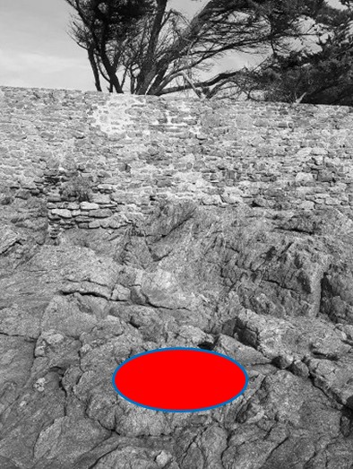
- Question 4 : Décrivez la roche sous cette zone (litage, grains, présence d'inclusion de roche). De quelle roche s'agit-il ?
- Question 4 : Describe the rock beneath this area (bedding, grains, presence of rock inclusion). What rock is it?
Point 3 : N 48° 38.070 W 002° 08.403
Observer la zone rouge de la photo WP3.
Observe the red area of photo WP3.
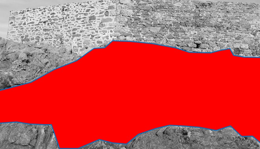
- Question 5 : Décrivez la roche sous cette zone (litage, grains, présence d'inclusion de roche). De quelle roche s'agit-il ?
- Question 5 : Describe the rock beneath this area (bedding, grains, presence of rock inclusion). What rock is it?
- Question 6 : Avec votre boussole évaluez l'orientation de la foliation. Est-elle cohérente avec l'histoire géologique régionale ?
- Question 6 : With your compass evaluate the orientation of the foliation. Is it consistent with regional geological history?
Point 4 : N 48° 38.081 W 002° 08.410
Observer la zone rouge de la photo WP4.
Observe the red area of photo WP4.
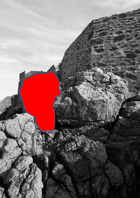
- Question 7 : Décrivez la roche sous cette zone (litage, grains, présence d'inclusion de roche). De quelle roche s'agit-il ?
- Question 7 : Describe the rock beneath this area (bedding, grains, presence of rock inclusion). What rock is it?
- Question 8 : Les évolutions des roches entre les WP2 / WP3 / WP4 sont-elles cohérentes ? Que montrent-elles ?
- Question 8 : Are the evolutions of the rocks between the WP2 / WP3 / WP4 consistent? What do they show?
Vous pouvez vous loguer sans attendre notre confirmation,
mais vous devez nous envoyer les réponses en même temps via notre profil (
fafahakkai).
S'il y a des problèmes avec vos réponses nous vous en ferons part.
Les logs enregistrés sans réponses seront supprimés.Une photo en Noir & Blanc de vous ou de votre GPS avec l'île Jouanne (pas pas les WPs) seraient la bienvenue, mais ne sont pas obligatoire.
You can log this cache without waiting for our confirmation, but you must send us the answers at the same time via our profile (fafahakkai).
If there is a problem with your answers we will notify you. The logs recorded without answers will be deleted.
A photo in black & amp; White from you or your GPS with Jouanne Island (not the WPs) would be welcome but are not mandatory.
Rappel concernant les « Earthcaches »: Il n'y a pas de conteneur à rechercher ni de logbook à renseigner. Il suffit de se rendre sur les lieux, de répondre aux questions ci-dessus et de nous renvoyer les réponses.
Reminder concerning "Earthcaches": there is neither a container to look for nor a logbook to sign. One need only go to the location, answer to the differents quiestions and send us the answers.