Yakutsk is the capital city of the Sakha Republic, Russia, located about 450 kilometers (280 mi) south of the Arctic Circle. Population: 269,601 (2010 Census) .
In geology, permafrost is ground, including rock or (cryotic) soil, at or below the freezing point of water 0 °C (32 °F) for two or more years. Most permafrost is located in high latitudes (in and around the Arctic and Antarctic regions), but alpine permafrost may exist at high altitudes in much lower latitudes. Ground ice is not always present, as may be in the case of nonporous bedrock, but it frequently occurs and it may be in amounts exceeding the potential hydraulic saturation of the ground material. Permafrost accounts for 0.022% of total water on earth and exists in 24% of exposed land in the Northern Hemisphere. It also occurs subsea on the continental shelves of the continents surrounding the Arctic Ocean, portions of which were exposed during the last glacial period.
A global temperature rise of 1.5 °C (2.7 °F) above current levels would be enough to start the thawing of permafrost in Siberia, according to one group of scientists.
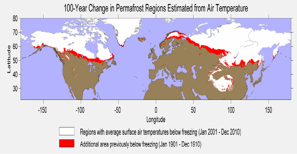
Permafrost is soil, rock or sediment that is frozen for more than two consecutive years. In areas not overlain by ice, it exists beneath a layer of soil, rock or sediment, which freezes and thaws annually and is called the "active layer". In practice, this means that permafrost occurs at an average air temperature of -2 °C or colder. Active layer thickness varies with the season, but is 0.3 to 4 meters thick (shallow along the Arctic coast; deep in southern Siberia and the Qinghai-Tibetan Plateau). In the Northern Hemisphere, 24% of the ice-free land area, equivalent to 19 million square kilometers, is more or less influenced by permafrost. Most of this area is found in Siberia, northern Canada, Alaska and Greenland. Beneath the active layer annual temperature swings of permafrost become smaller with depth. The deepest depth of permafrost occurs where geothermal heat maintains a temperature above freezing. Above that bottom limit there may be permafrost, whose temperature doesn't change annually—"isothermal permafrost".
The extent of permafrost varies with the climate. Today, a considerable area of the Arctic is covered by permafrost (including discontinuous permafrost). Overlying permafrost is a thin active layer that seasonally thaws during the summer. Plant life can be supported only within the active layer since growth can occur only in soil that is fully thawed for some part of the year. Thickness of the active layer varies by year and location, but is typically 0.6–4 m (2.0–13.1 ft) thick. In areas of continuous permafrost and harsh winters, the depth of the permafrost can exceed 1,400 m (4,600 ft). Permafrost can also store carbon, both as peat and as methane. Work investigating the permafrost carbon pool size estimates that 1400–1700 Gt of carbon is stored in the northern circumpolar permafrost region. While a recent study that includes stores of the Tibetan Plateau, estimates total carbon pools in the permafrost of the Northern Hemisphere to be 1832 Gt. This large carbon pool represents more carbon than currently exists in all living things.
Ecological consequences
Worldwide, permafrost contains 1700 billion tons of organic material equaling almost half of all organic material in all soils. This pool was built up over thousands of years and is only slowly degraded under the cold conditions in the Arctic. The amount of carbon sequestered in permafrost is four times the carbon that has been released to the atmosphere due to human activities in modern time. One manifestation of this is yedoma, which is an organic-rich (about 2% carbon by mass) Pleistocene-age loess permafrost with ice content of 50–90% by volume.
Formation of permafrost has significant consequences for ecological systems, primarily due to constraints imposed upon rooting zones, but also due to limitations on den and burrow geometries for fauna requiring subsurface homes. Secondary effects impact species dependent on plants and animals whose habitat is constrained by the permafrost. One of the most widespread examples is the dominance of Black Spruce in extensive permafrost areas, since this species can tolerate rooting pattern constrained to the near surface.
One gram of soil from the active layer may include more than one billion bacteria cells. If placed along each other, bacteria from one kilogram of active layer soil will form a 1000 km long chain. The number of bacteria in permafrost soil varies widely, typically from 1 to 1000 million per gram of soil. Most of these bacteria and fungi in permafrost soil can not be cultured in the laboratory, but the identity of the microorganisms can be revealed by DNA-based techniques.
Should a substantial amount of the carbon enter the atmosphere, it would accelerate planetary warming. A significant proportion will emerge as methane, which is produced when the breakdown occurs in lakes or wetlands. Although it does not remain in the atmosphere for long, methane traps more of the sun’s heat. The Arctic region is one of the many natural sources of the greenhouse gas methane. Global warming accelerates its release, due to both release of methane from existing stores, and from methanogenesis in rotting biomass. Large quantities of methane are stored in the Arctic in natural gas deposits, permafrost, and as submarine clathrates. Permafrost and clathrates degrade on warming, thus large releases of methane from these sources may arise as a result of global warming. Other sources of methane include submarine taliks, river transport, ice complex retreat, submarine permafrost and decaying gas hydrate deposits. Preliminary computer analyses suggest that permafrost could produce carbon equal to 15 percent or so of today’s emissions from human activities.
A hypothesis forwarded by Sergey Zimov is that the reduction of herds of large herbivores has increased the ratio of energy emission and energy absorption tundra (energy balance) in a manner that increases the tendency for net thawing of permafrost. He is testing this hypothesis in an experiment at Pleistocene Park, a nature reserve in northeastern Siberia.
Climate change and slope stability
Over the past century, an increasing number of alpine rock slope failure events in mountain ranges around the world have been recorded. It is expected that the high number of structural failures is due to permafrost thawing, which is thought to be linked to climate change. In mountain ranges, much of the structural stability can be attributed to glaciers and permafrost. As climate warms, permafrost thaws, which results in a less stable mountain structure, and ultimately more slope failures.

Question:
Who and when was etablished the permafrost research station?>
What are the dangers of melting permafrost (quoting 2)?
How many years has the ice under the institute ? What can we see trapped in this layer ?
Summer, whith +35°C in the street, how much permafrost melts in Yakutia ?
If you want to discover a place where permafrost is highlighted ... N 62° 02.648 E 129° 37.459
As possible, post your photos ...
__________________________________________________________________________
Яку́тск (якут. Дьокуускай) — город в России, столица Республики Саха (Якутия). Самый крупный и старейший город в Якутии, один из старейших городов Сибири. Административный, индустриальный, культурный, финансовый и научный центр северо-востока России.
«Вечная мерзлота» (многолетняя криолитозона, многолетняя мерзлота) — часть криолитозоны, характеризующаяся отсутствием периодического протаивания. Общая площадь вечной мерзлоты на Земле — 35 млн км². Распространение — север Аляски, Канады, Европы, Азии, острова Северного Ледовитого океана, Антарктида. Районы многолетней мерзлоты — верхняя часть земной коры, температура которой долгое время (от 2—3 лет до тысячелетий) не поднимается выше 0 °C. В зоне многолетней мерзлоты грунтовые воды находятся в виде льда, её глубина иногда превышает 1 000 метров.
Общепринятое название — «вечная мерзлота», термин «многолетняя мерзлота» используется в основном петербургской географической научной школой.
Вечная мерзлота — явление глобального масштаба, она занимает не менее 25 % площади всей суши земного шара. Материк, где вечная мерзлота отсутствует полностью, — это Австралия, в Африкевозможно её наличие только в высокогорных районах. Значительная часть современной вечной мерзлоты унаследована от последней ледниковой эпохи, и сейчас она медленно тает. Содержание льда в промерзлых породах варьируется от нескольких процентов до 90 %. В вечной мерзлоте могут образоваться залежи газовых гидратов, в частности — гидрата метана.
От 60 % до 70 % территории России — районы вечной мерзлоты. Наиболее широко она распространена в Восточной Сибири и Забайкалье.
Самый глубокий предел вечной мерзлоты отмечается в верховьях реки Вилюй в Якутии. Рекордная глубина залегания вечной мерзлоты — 1 370 метров — зафиксирована в феврале 1982 года.