EARTHCACHE INACESSIBLE A MAREE HAUTE
ET A FORT COEFFICIENT
En Géologie et en Géomorphologie, un sillon est une longue et étroite dépression de terres
On peut distinguées 5 categories de sillon :
- Le tombolo : Ce cordon relie une masse émergée à quelque distance du littoral. Quelquefois ce tombolo peut-être double comme celui très connu de Hyères dans le Var qui relie la presqu’île de Gien à la terre.
- La queue de comète : Son nom illustre bien l’aspect des dépôts « à l’abri » d’un obstacle (rochers, ilôt ou île) étirés dans le sens du courant dominant.
- La flèche sub-parallèle à la côte : Pour ce modèle la terminologie est claire, les pertes de charge du courant lui-même parallèle au rivage entrainent un dépôt de sédiments de même direction que le trait de côte.
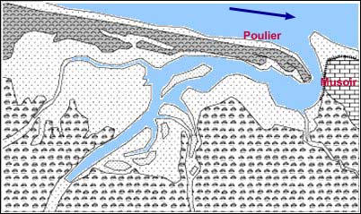
- Le poulier (aussi appelé flèche à pointe libre) : C’est une des formes géomorphologiques des plus connues dans la Rade, partant d’une des rives, elle provoque l’avancé d’un épi terminé en crochet qui barre progressivement un estuaire ne laissant souvent qu’un étroit passage. Les courants assez forts dans ce resserrement peuvent creuser la rive opposée : le musoir.
- Les chicanes : Quelquefois les conditions sont réunies pour qu’un poulier démarre de chaque côté de l’estuaire créant une structure bien évidemment conforme à cette appellation
En terme géomorphologique, un poulier est un cordon littoral en galets qui se décolle de la côte, en bordure de la baie, pour donner une flèche littorale avançant en travers d'un estuaire et tendant à le fermer, parvenant du moins à le rétrécir et à l'obliger au surcreusement.
Ce terme, d'origine picarde, vient de boulier (accumulation de boules, ou galets). Il a été introduit dans le vocabulaire géomorphologique par Abel Briquet (1930).
(source : http://rade-de-brest.infini.fr/les-sillons-de-la-rade-de-brest.html)
Rappel : Sur une Earthcache, il n'y a pas de boites à trouver
Pour valider votre visite sur le site,
Loguez cette cache "Found it" et envoyez-moi les propositions de réponses
en precisant le nom de l Earthcache
via mon profil soit via la messagerie geoocaching.com
et je vous contacterai en cas de probleme
LES LOGS ENREGISTRES SANS REPONSES SERONT SUPPRIMES
QUESTIONS :
Au coordonnée de la cache,
Q1 : Qu obervez vous pour la végétation ?
puis rendez vous aux coordonnées N 48° 24.390 W 004° 20.756
Q2 : Observez le sol, de quoi est il composé ?
Q3 : Par rapport au sol qui vous entoure (dans les 30m) Diriez vous que vous etes en peu plus bas ?
ou un peu plus haut ?
Q4 : Quelle est la pincipale différence entre un Poulier et un Tombolo ?

EARTHCACHE INACESSIBLE HIGH TIDE
AND FORT COEFFICIENT
Geology and Geomorphology, a groove is a long narrow depression of land
5 furrow can be distinguished categories:
The tombolo: This cord connects a landmass some distance from the coast. Sometimes it tombolo perhaps twice as that famous Hyères in the Var, which connects the peninsula of Gien grounded.
The comet tail: The name illustrates the appearance of deposits "immune" to an obstacle (rock, island or island) stretched in the direction of the mainstream.
The sub-arrow parallel to the coast: In this model the terminology is clear, the current pressure loss itself parallel to the shore result in the same direction sediment deposition that the coastline.
The poulier (also called open arrow points): This is a geomorphological forms of the best known in the Bay, starting from one of the banks, it causes advanced an ear hook that finished bar gradually estuary does often leaving a narrow passage. The relatively strong currents in this tightening can dig the opposite shore: the knuckle.
Baffles: Sometimes the conditions are right for a poulier starts each side of the estuary creating a course consistent structure to that designation
In terms geomorphological, a poulier is a coastal pebble that falls off the coast, bordering the bay, to give a spit advancing across an estuary and tending to close, reaching at least to shrink and to compel the deepening.
This term, of Picardy originally comes from abacus (accumulation of balls or rollers). It was introduced in the geomorphological vocabulary by Abel Briquet (1930).
(Source: http://rade-de-brest.infini.fr/les-sillons-de-la-rade-de-brest.html)
On Earthcache, no boxes to find
To validate your visit to the site,
Log in this cache "Found it" and send me the answers proposals
by specifying the name of the Earthcache
via my profile or via email geoocaching.com
and I will contact you in case of problems
LOGS WITHOUT ANSWERS WILL BE DELETED
QUESTIONS
To coordinate the cache,
Q1: Qu obervez you for vegetation?
then go to the coordinates N 48 ° W 004 ° 20 756 24 390
Q2: Watch the ground, what is it made of?
Q3: From the ground around you (within 30m) would you say you are in little lower? a bit higher ?
Q4 : What is the difference between a POULIER and a TOMBOLO?