
The Best of the LoHud is a Geotrail composed of 30 caches that will take you to some of the best locations the LoHud has to offer! For more information, click on the banner above.
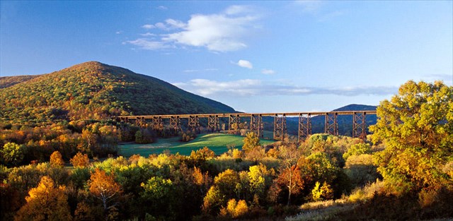
The Moodna Viaduct is an iron railroad trestle spanning the Moodna Creek and its valley at the north end of Schunemunk Mountain. The bridge was constructed between 1904 and 1908 by the Erie Railroad and was opened for service in January 1909. The trestle spans the valley for 3,200 feet (975 m) and is 193 feet (59 m) high at its highest point, making it the highest and longest railroad trestle east of the Mississippi River. The open design of the trestle was used to reduce wind resistance and is a major reason why the trestle is still in service today, used primarily for Metro North commuters. The viaduct offers one of Orange County's most picturesque spots, especially during the fall foilage season.
The cache is hidden within Schunemunk State Park nearby; state permit GC-126-SCH. Please park at the listed parking coordinates, this is the trailhead for the white Trestle Trial. You will briefly follow the road, then make the climb up. Once level with the trestle, you will find the start of the red Otterkill Trail, that will take you to the cache. Please DO NOT venture out near the railroad tracks, they are private property and they are active tracks. The cache itself is further away and far above the tracks.