A gorge is a narrow valley with steep, rocky walls located between hills or mountains. The term comes from the French word gorge, which means throat or neck. A gorge is often smaller than a canyon, although both words are used to describe deep, narrow valleys with a stream or river running along their bottom.
A number of natural forces form gorges. The most common is erosion due to streams or rivers. Streams carve through hard layers of rock, breaking down or eroding it. Sediment from the worn-away rock is then carried downstream. Over time, this erosion will form the steep walls of a gorge. The gradient of a river is the rate at which it loses elevation along its course. This loss determines the river’s slope and to a large extent its rate of flow. The flooding of streams or rivers increases the speed and intensity of this erosion, creating deeper and wider gorges.
Softer rocks in the streambed erode, or wear away, faster than harder rocks. This process is known as differential erosion. The result of differential erosion is that as the streambed wears away, the stronger rocks remain and eventually begin to break up the flow of the stream. The many tiny waterfalls they create make the slope of the stream steeper. Rapids are sections of a river where the gradient of the river bed is relatively steep resulting in an increase in the river’s turbulence and velocity. They form where the gradient of the river is steep and the bed is composed mainly of hard rocks. In sections of the snowy river you will notice large rocks remain or have fallen into the river course (depending on the height of the river when you paddle it these rocks may be submerged or partially submerged). Through Tulloch Ard gorge there is evidence that the more erosion resistant hard rock that lines the tall cliff faces has in fact fractured and fallen into the river creating some of the larger features and white water rapids which are present in the river system. As the river continues to develop over thousands of years, you can expect to see the gorge get deeper and these rapids potentially become waterfalls. Such as Pinch River falls which can be found in the NSW section of the river.
Potholes are cylindrical holes drilled into the bed of a river that vary in depth & diameter from a few centimeters to several metres. They’re found in the upper course of a river where it has enough potential energy to erode vertically and its flow is turbulent. In the upper course of a river, its load is large and mainly transported by traction along the river bed. When flowing water encounters bedload, it is forced over it and down cuts behind the bedload in swirling eddie currents. These currents erode the river’s bed and create small depressions in it.
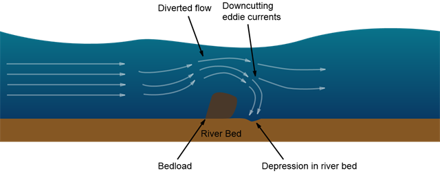
As these depressions deepen, pebbles can become trapped in them. As a result of the eddie currents, the pebbles drill into the depressions making them more circular, wider & deeper. Many rapids exhibit this process and as time goes on the area after a rapid may increase in depth. Pebbles will only be able to erode a river’s bed though if the rock the pebble’s made of is stronger than the rock the river bed is made of.
Rapid down cutting by the Snowy River in Gelantipy Rhyodacite has produced the deep Tulloch Ard Gorge that you see today. This contrasts with the relatively less steep valley shape occurring in the granite and Silurian sediments surrounding the area. Take note of this as you approach and exit the gorge.
Rhyodacite is an extrusive volcanic rock intermediate in composition between dacite and rhyolite, and is quite commonly found in many regions of Victoria. Gelantipy Rhyodacite is the specific type found in this particular region. Rhyodacite is a type of Igneous rock and is available in black to grey, dark greenish - grey colors. The Rhyodacite mineral content includes Amphibole, Apatite, Biotite, Feldspar, Garnet, Hornblade, Magnetite, Plagioclase, Pyroxene, Quartz, Zircon. Its compound content includes Ca, Fe, Potassium Oxide, NA, Potassium, Silicon Dioxide.
If you’re interested in a more detailed understanding of the rocks in this region take a look at the nearby Earth Cache Gorgeous
Take a moment at GZ and try to imagine the amount of water that naturally flowed through this river before the hydro scheme significantly reduced it to today’s levels. You can get a better idea of this if you complete the earthcache Bridge Over Snowy Waters
LOGGING REQUIREMENTS
When you reach the Tulloch Ard Gorge you will need to navigate through or around some of the largest rapids on the Snowy River. This EarthCache focuses on an area between two of them, ‘The Washing Machine’ and ‘Gentle Annie’.
To log this EC, send your answers through to the following questions. You can log straight away, however, any logs which do not email/message through accurate answers will be deleted so it might be best to wait for a response.
1. Determine the gradient of the river section between the top of The Washing Machine and the bottom of Gentle Annie. What is the drop in elevation (meters above sea level)
2. Between The Washing Machine and Gentle Annie there is a vertical cliff face on the western bank (at the posted coords). It is clearly made up of hard rock which is less prone to the erosive power of the river.
- Estimate the height of the cliff face. How long do you think it has taken to erode the river bed down to its current position?
- Describe the colours of the rock found on the cliff face. From what is visibly exposed, how much of it do you believe is Gelantipity Rhyodacite?
- What direction are the major fractures in the cliff travelling? (think of a clock face, from 11 to 4 for example) How would they impact this section of the river if they were to cause large slabs of rock to fall into it?
- Look around the base of the cliff. How much higher from the water level you have paddled in on would the water level need to be to get the debris there. What would this increase in water level mean to the future development of the river course?
**WARNING**
This EC is situated on the very popular 72km section of the Snowy River beginning at McKillops Bridge and finishing in Buchan and has some of the most spectacular scenery in the area. The specific section where the cache is located is extremely remote with no phone reception and no road or trail access, if you get into trouble out here you had better be sure you’ve got a plan.
The Snowy River is full of white water rapids which depending on the water levels will vary in difficulty. You will need to get through some of the biggest and best before reaching this cache.
White Water safety is paramount if you are going to attempt this cache. The following are a few guidelines but the responsibility is on you to ensure you have adequate training, physical capabilities and the right equipment to participate in the activity. There are a number of companies which take expeditions down the river. It is highly recommended that you do not do this trip alone and that you have a fully trained river guide assist you.
-
Always wear a life jacket, or personal flotation device (PFD).
-
Be safe and comfortable. Wear the protective gear such as a helmet.
-
Make sure you have the right outerwear for the day to keep you warm. Wearing a wet suit, splash jacket, and proper river shoes can make the trip much more comfortable.
-
Hold the paddle properly.
-
Stay in the boat!
-
Know the proper swimming techniques for being in fast flowing water and rapids.
-
Know the river commands for communicating on the river.
-
Remember to check river levels and weather conditions with the Bureau of Metrology before you leave.
-
Always leave details of your itinerary with a responsible person and check in as often as possible.