Two types determine the regular flooding of the dynamic structure:
1.A large-area flooding:
Several times a year the sandbank is flooded in large storms. Large waves overcome the very shallow and low sandbank and put it under water within a few hours. The water depth is between 10 and 30 cm. In this case, a flow hardly develops and is thus relatively harmless. The water then runs off again within a week.
2.The channel breakthrough:
In some years, a strong breakthrough through the sandbank is the result of strong winter storms. The rocky peninsula Prasonisi becomes an island. The channel can then be open for months or years and is temporarily so deep that one can only overcome it by floating. The wind creates a very strong current in the constriction. During this time, there is a danger of life!
The sand is very fine, almost without stones and offers through the large surface optimal conditions for the emergence of waves. The waves are also called ripples which means as much as "small wave".
The small wave is evoked and defined by a flowing medium (air or water) Geometric elements such as the ripple comb, the trough, the height and the length determine the sediment structure.
Formation of waves:
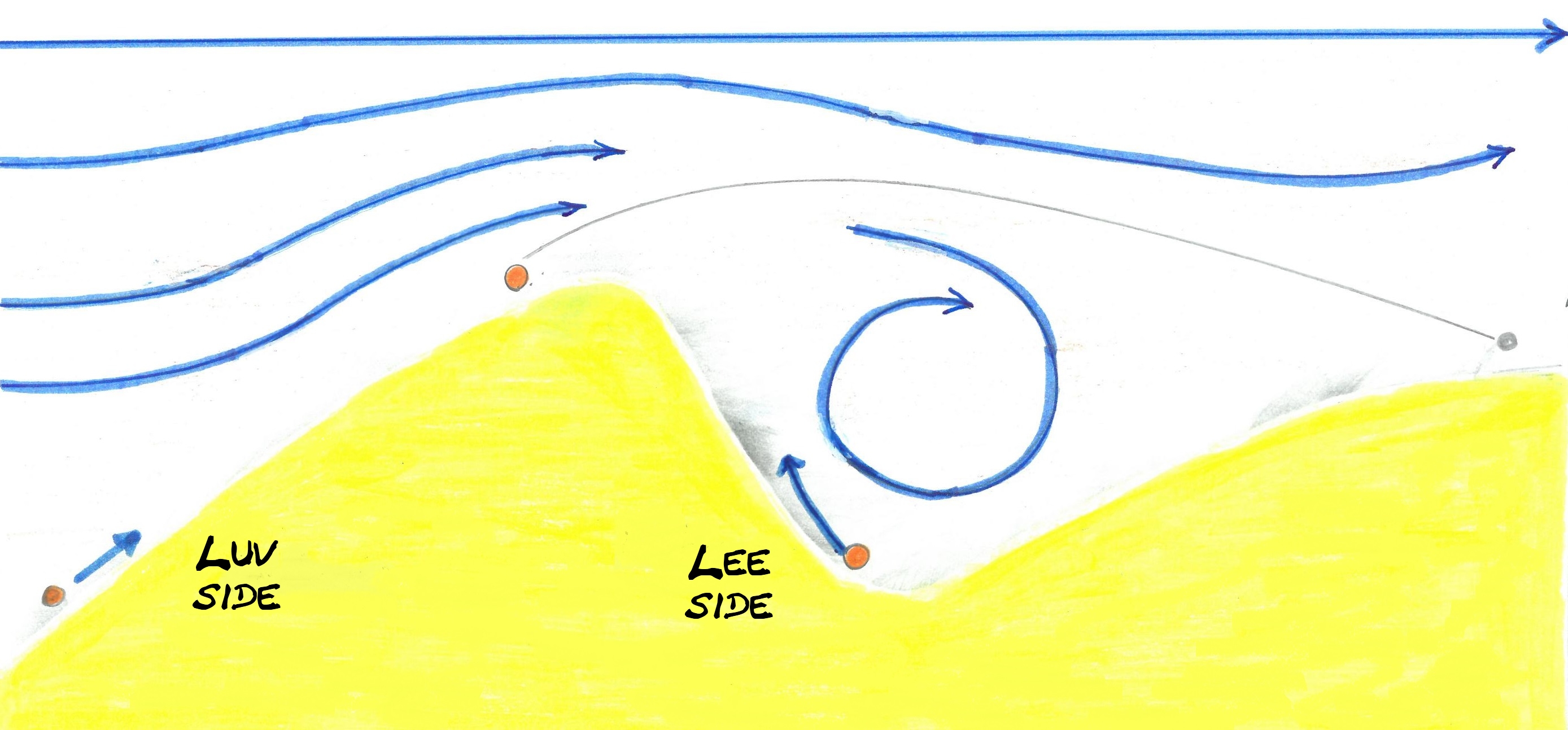
As soon as a flow exceeds a critical velocity at the boundary surface, sand grains entrained. Everything begins with a random bump, a shell, a small stone, or a small sand accumulation. The sand grains entrained by the flow remain attached to the obstacle and the accumulation increases. A self-reinforcing process is set in motion. The larger the obstacle, the more sand grains are deposited. On the downstream side, the lee side, there is a lower pressure. There a small vortex forms, which leads to a depression in the sand and drives further grains of the Leesite up. - a ripple arises.
From a certain height, the current at the top of the hill becomes so strong that sand grains immediately move on and the ripple no longer grows. At a short distance and perpendicular to the direction of flow, the entrained sand grains sink to the ground and the ripple formation process begins anew.
Thus, two typical combing processes can arise:
1.Flow ripple:
Flow ribs formed by / in continuous flow from one direction. Usually, parallel wave patterns with asymmetrical wave mountains arise. The windward side (directed towards the current) ascending long and flat, while the lee side falls markedly steeper.
Flow ripple
2.Oscillation ripple:
In contrast to flow ripples, oscillating ripples arise when the flow changes its direction repeatedly - oscillates. Intertwined wave patterns with symmetrical waves are the result. The average height is between 3 and 5 cm. The distance from wave peak to wave trough (the wavelength) is 4-60 cm.
Oscillation ripple
Source: Wikipedia, Welt der Physik, Spektrum
Log condition:
1) Determine the current wind direction. Which method did you apply?
2) Please check the ripples between Prasonisi and Rhodes. What kind of ripple can you find?
3) Which factors determine the waveform and size?
You can log in immediately. If something is wrong, I'll sign up. We are very looking forward to pictures.
ARNJCT
########### GERMAN ###########
Prasonisi ist eine ca. 3 km² kleine Insel, die durch eine Sandbank mit Rhodos verbunden ist.
Der engste Punkt dieser Bank wird als Isthmus bezeichnet und trennt das Mittelmeer vom ägäischen Meer.
Die regelmäßige Überflutung der dynamischen Struktur wird durch zwei Arten bestimmt:
1.Eine Großflächige Überflutung:
Mehrmals pro Jahr wird die Sandbank bei starken Stürmen großflächig überflutet. Große Wellen überwinden die sehr flache und niedrig gelegene Sandbank und setzen sie binnen weniger Stunden unter Wasser. Die Wassertiefe beträgt dabei zwischen ca. 10 und 30 cm. Eine Strömung entsteht hierbei kaum und ist damit relativ ungefährlich. Das Wasser läuft dann innerhalb einer Woche von selbst wieder ab.
2.Der Kanal-Durchbruch:
In manchen Jahren entsteht durch starke Winterstürme ein Durchbruch durch die Sandbank. Die felsige Halbinsel Prasonisi wird dadurch zur Insel. Der Kanal kann dann für Monate oder Jahre offen sein und wird zeitweise so tief, dass man ihn nur schwimmend überwinden kann. Durch den Wind herrscht in der Verengung eine sehr starke Strömung. In dieser Zeit herrscht Lebensgefahr!
Der Sand ist durchgängig feinsandig, nahezu ohne Steine und bietet durch die große Fläche optimale Bedingungen zur Entstehung von Wellen. Die Wellenmuster werden in Fachkreisen auch Rippelmarken oder kurz Rippel genannt, nach dem englischen Wort "ripple", das so viel wie "kleine Welle" bedeutet.
Die kleine Welle wird durch ein strömendes Medium (Luft oder Wasser) hervorgerufen und definiert. Geometrischen Elemente wie der Rippelkamm, der Trog, die Höhe und die Länge bestimmen die Sedimentstruktur.

Entstehung von Wellen:
Sobald eine Strömung eine kritische Geschwindigkeit an der Grenzfläche übersteigt, werden Sandkörner mitgerissen. Alles nimmt seinen Anfang mit einer zufälligen Unebenheit, einer Muschel, einem kleinen Stein oder einer kleinen Sandanhäufung. Die von der Strömung mitgerissenen Sandkörner bleiben am Hindernis hängen und die Anhäufung vergrößert sich. Ein selbstverstärkender Prozess wird in Gang gesetzt. Je größer das Hindernis wird, desto mehr Sandkörner lagern sich an. Auf der Strömungsabgewandten Seite, der Leeseite, herrscht ein niedrigerer Druck. Dort bildet sich ein kleiner Wirbel, der zu einer Vertiefung im Sand führt und weitere Körner der Leeseite hinauf treibt - ein Rippel entsteht.
Ab einer gewissen Höhe wird die Strömung an der Spitze des Hügels so stark, dass Sandkörner gleich weiter bewegt werden und der Rippel nicht mehr wächst. In kurzer Entfernung und senkrecht zur Strömungsrichtung sinken die mitgerissenen Sandkörner zu Boden und der Rippelbildungsprozess beginnt von neuem.
So können zwei typische Kammverläufe entstehen:
1.Strömungsrippel:
Strömungsrippel bilden sich durch/bei kontinuierliche Strömung aus einer Richtung. Dabei entstehen meist parallele Wellenmuster mit asymmetrischen Wellenbergen. Die Luvseite (zur Strömung hin gerichtet) ist lang und flach ansteigend, während die Leeseite deutlich steiler abfällt.
Strömungsrippel
2.Oszillationsrippel:
Im Gegensatz zu Strömungsrippel entstehen Oszillationsrippel, wenn die Strömung immer wieder ihre Richtung ändert, - sie oszilliert. Verschlungene Wellenmuster mit symmetrischen Wellenbergen sind die Folge/das Ergebnis. Die durchschnittliche Höhe liegt zwischen 3 und 5 cm. Der Abstand von Wellenberg zu -tal (die Wellenlänge) liegt zwischen 4-60 cm.
Oszillationsrippel
Quellenhinweis: Wikipedia, Welt der Physik, Spektrum
Logbedingung:
1) Bestimme die aktuelle bzw. die letzte Windrichtung. Welche Methode hast du angewandt?
2) Untersuche bitte die Rippel zwischen Prasonisi und Rhodos.
Um welche Art von Rippel handelt es sich?
3) Durch welche Faktoren werden die Wellenform und -größe bestimmt?
Ihr dürft sofort loggen. Sollte etwas nicht stimmen, melde ich mich. Wir freuen uns sehr auf Bilder.