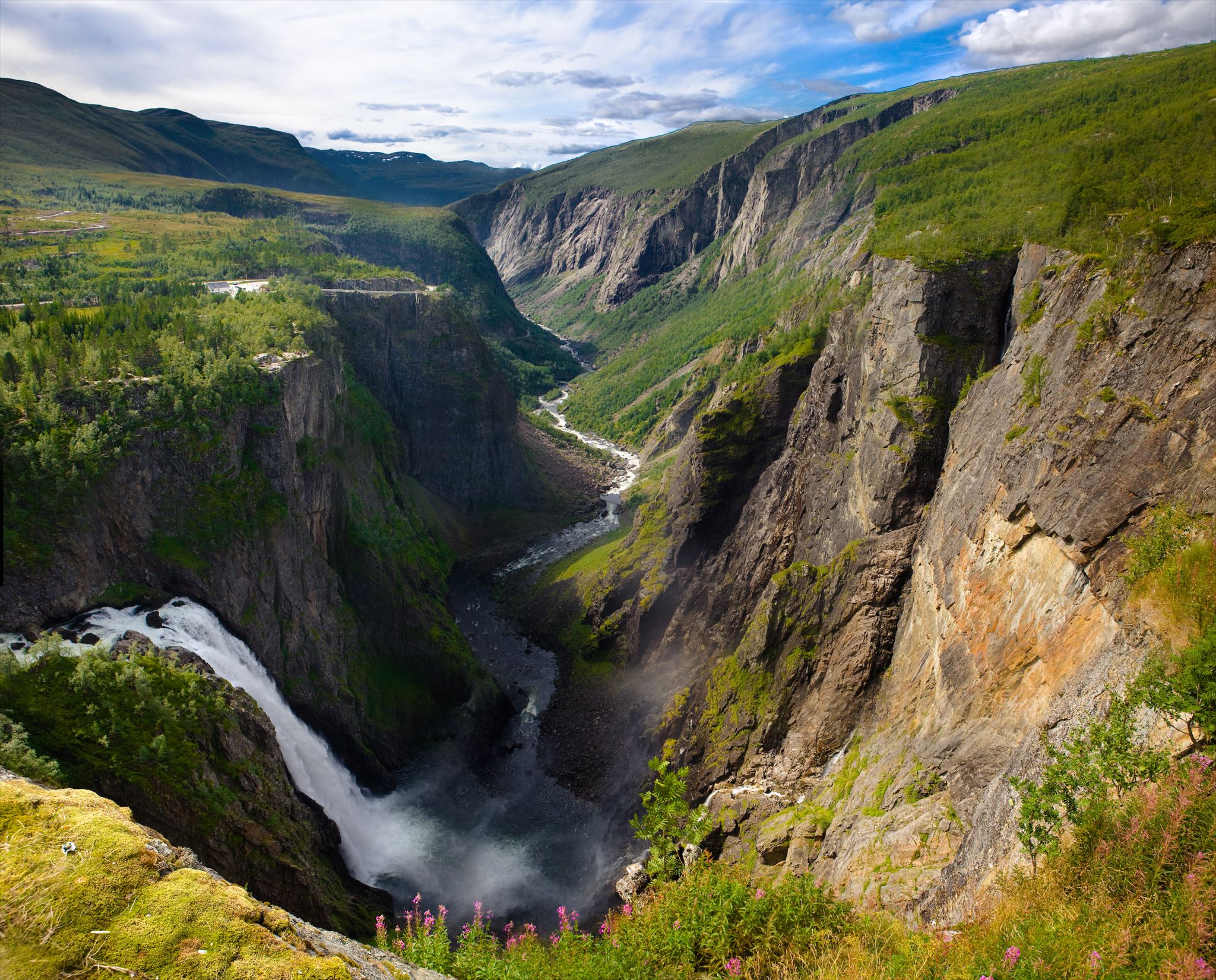
Vøringsfossen i Måbødalen - EarthCache
Den faste fjellgrunnen Måbødalen er graven ut i, er todelt. Det meste av dalen er skore i grå granitt og gneisar laga ved omdanning av granitt seint i grunnfjellstida, delvis ved oppattsmelting og plastisk folding av mørke og ljose parti.
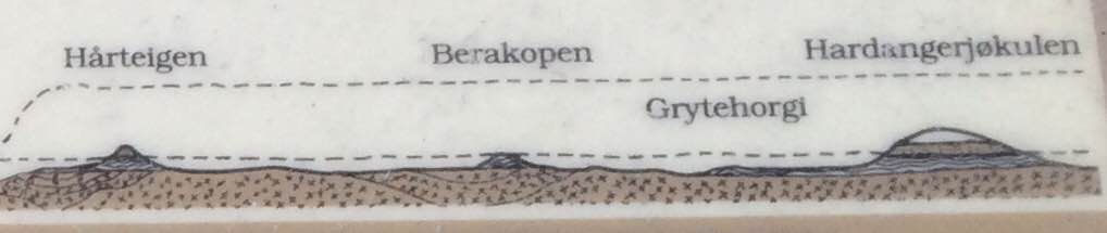
I toppane mellom 1000 og 1100 m.o.h. ligg yngre bergartar over grunnfjellsgneisane. Det er svart og grå skifer med kalksteinsoner i. Grenseflata mellom desse store bergart-einingane, med gneis nedst og skifer øvst, er svært tydeleg i sørvest-stupet av Grytehorgi. For 450-550 millionar år sidan, kambrisk tid, var denne grenseflata ei gamal landflate som vart botn i eit hav der skifer og kalk vart avsett.
I nyare geologiske periodar vart den faste fjellgrunnen broten opp med store sprekkar og forkastingar. Knust fjell langs desse brotflatene har letta og styrt utforminga av Måbødalen.
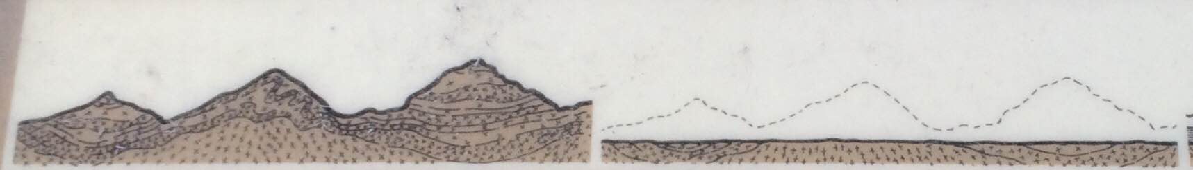
Det eldste landskapet vi anar konturane av i dette området, er restane av eit sletteland i 1200-1300 meters høgde. Dette ser vi om vi knyter saman topphøgder inpå dalsidene og innover Hardangervidda. I tertiærtida vart detta slettelandet lyft steg for steg frå ein lågare posisjon over havet og opp dit det ligg no.
Før og under landhevinga grov elvar i lang tid ut i breie, opne dalar i dette slettelandet. Sysendalen er ein slik dal. Fleire istider med nedising og avsmeiting har dei siste 2 millionar år, kvartærtida, grave ut skarpt nedskorne dalar, som Måbædalen og Hjølmodalen, i fara etter dei breie dalane. To dalgenerasjonar er såleis representerte her.
Danning av Vøringsfossen
URTID/GRUNNFJELLSTID (meir ann 1500 mill. år frå notid)
Grunnfjellet vart danna av størkna steinsmelte (lava) og omkystallisering i lag djupt under jordoverflata. Grunnfjellet vart seinare folda saman til ei fjellkjede. I omlag 350 mill. år vart denne urtidsfjellkjeden av granitt og gneis utsett for erosjon og brote ned til eit nesten flatt landskap nær havnivå.
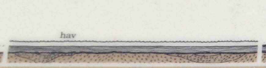
KAMBRISK TID OG ORDOVICIUM (600-450 mill. år frå notid)
Det flate landskapet vart langsamt fløymd over av hav. Store mengder leire, sand og grus vart ført med elvane og avsett (sedimentert) på grunnfjellet som no var havbotn.
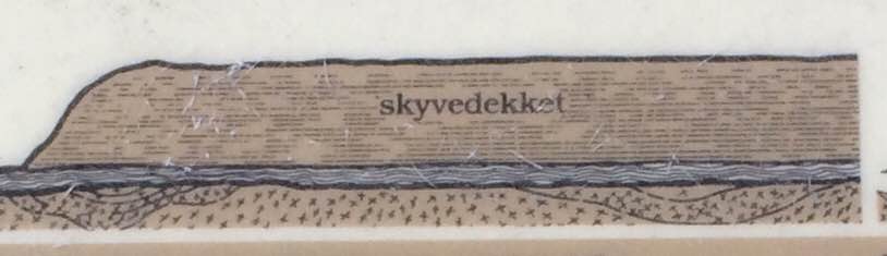
SILUR OG DEVONTID (450-350 mill. år frå notid)
Store flak av grunnfjell (“Jotundekket”) kom sigande frå nordvest og la seg over havsedimenta, som dermed vart utsette for eit voldsomt trykk og omdanna til fylitt. Området var no bygd opp av grunnfjell i botnen og på toppen, med havsediment i midten.
KARBON, PERM, TRIAS, JURA OG KRITT (350-60 mill. år frå notid)
Fjellmassene i denne lagdelte overflata vart utsette for nedbrytande krefter slik at berre restar av havsedimenta og skyvedekket over urtidsfjellkjeden står att.
TERTIÆR OG KVARTÆRTID
60 og 2 millionar år frå notid
Tidleg i tertiærtida heva landet seg. Elvar grov i lang tid ut breie, opne dalar i dette slettelandet. I kvartærtid har is og smeltevatn skore inn tronge og djupe dalar i det eldre dalsystemet.
GJELET VED VØRINGSFOSSEN
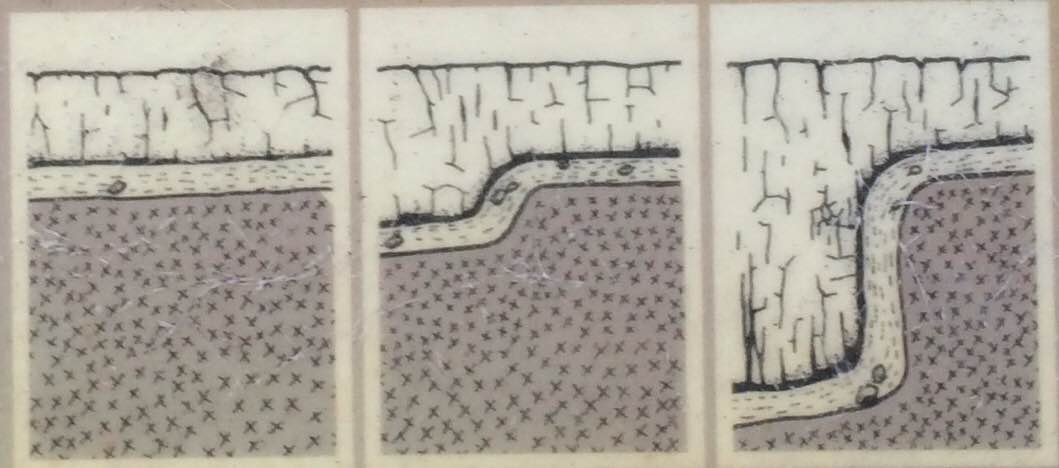
Gjelet og jettegrytene aust for elveleiet ovanfor Vøringsfossen er spor etter den gravande verksemda til smeltevassløp under is. Dei store smeltevassmengdene som fann veg under isen grov også ut gjelet ved Vøringsfossen.
EarthCachen
Hvis du ønsker å logge dette EarthCache som finnes, så må du besøk dalen og svar på spørsmålene. Send dine svar til meg via e-post eller meldingssentralen. Hvis du er flere geocachere som logger dette EarthCache sammen, da bare en av dere må sende inn svar. Hvis svarene er ikke akseptabelt så vil jeg kontakte deg. Så du kan logge cachen direkte når du har send meg svar, trenger du ikke å vente på svaret mitt.
Spørsmålene:
1. Se på steiner som du kan finne på stedet. Hvordan ser de ut? Hvordan har dem blitt dannet? Hvordan kan du være sikker på det?
2. Er steinene som du finner på denne plass representative for dalen? Tror du at disse typer av bergarter opptrer mye i vally eller er de sjeldne? Hvorfor tror du det?
3. Bergartene i dalen består hovedsakelig av magmatiske og metamorfe bergarter. Hvordan kan du være sikker på det? Hvordan ville dalen se om den besto hovedsakelig av sedimentære bergarter?
4. Valgfritt: Last opp et bilde av deg og / eller din GPSr på stedet til loggen. Dette er helt valgfri og er ikke et krav logging.
[ENG]
Vøringsfossen i Måbødalen - EarthCache
Clearly visible layering or stratification is one of the chief characteristics of the bedrock that the Måbødal is carved from. Common grey granite and mineral masses formed by the transmutation of granite under conditions of extreme heat and pressure compose the greatest part of the valley. Between 1000 and 1100 meters, however, "younger" rock types form the summits which cap this granite/mineral base. This is shale, black and grey, which typically contains belts of limestone.
The borderline between these distinct strata - granite and mineral underneath, and shale above, is clearly visible on the southwest escarpment of the Grytehorgi Mountain. This same borderline was once an ancient plain that came to be covered, in the Cambrian period, by an ocean Deposits of mud or clay (shale) and lime gradually accumulated there between 550 and 450 million years ago.
In more recent geological periods the area's rock formations have been subject to extensive fissuring and other geological dislocations. Fractured rock masses along exterior crack-lines have played an important role in "easing" the shaping of the valley.
Contours of the oldest landscape in this area that are perceivable today are those of a former plateau, lying at an altitude of between 1200 and 1300 meters. We see this if we connect with our imaginations the tops of the valleys, in a broad movement sweeping towards the Hardangervidda Mountain Plateau. This plateau was raised little by little, during the Tertiary period, from a much lower altitude to where it may still now be traced.
Before and during these great upheavals of the earth's crust, rivers gouged out broad valleys in this former plateauland. The Sysendal Valley is an example of this process. Several glacial periods of concurrent freeze and thaw, have during the Quaternary period (the last 2 million years) carved out the sharply eroded valley systems. Two quite distinct "generations" of valleys are thus represented in this area.
Creation of the Vøringsfossen
PRIMORDIAL OR BEDROCK ERA (more than 1500 million years from now)
The bedrock was created by solidified magma (lava) and changed in layers deep under the earth's surface. The bedrock was later folded together into a mountain range. In about 350 million years this bedrock mountain range of granite and gneiss was exposed to erosion and broke down to an almost flat landscape near sea level.
CAMBRIAN AND ORDOVICIAN TIME (600-450 million years from now)
The flat landscape was during a long time covered by the sea. Large quantities of clay, sand and gravel were brought with the streams and settled on the bedrock that now was the oceanfloor.
SILURIAN AND DEVONIAN TIME (450-350 million years from now)
Large pieces of bedrock ( "Jotun Deck") came from northwest and settled over ocean sediments, which then was exposed to tremendous pressure and metamorphose and was formed into phyllite. The area was now built up of bedrock in the bottom and on top, with ocean sediments in the middle.
CARBON, PERM, TRIAS, JURASSIC AND CRETACEOUS TIME (350-60 million years from now)
Mountain Masses in this layered surface-quarter was exposed to disruptive forces, leaving only the remains of ocean sediments and the bedrock cover.
TERTIARY AND QUATERNARY (60 and 2 million years from now)
Early in the Tertiary era tha land brought itself up. Rivers carved for a long time out broad, open valleys in this plain. In quaternary time the ice and meltwater cut into narrow and deep valleys in the elderly valleysystem.
THE RAVINE AT VØRINGSFOSS
Canyon and potholes east of the riverbed above the Vøringsfossen are traces of the carving activities of the meltwater under the inland ice. The large amounts of meltwater found it's way under the ice carved also the ravine at Vøringsfossen.
This EarthCache
If you want to log this EarthCache as a found, then you have to visit the valley and answer the questions. Send your answers to me through e-mail or message center. If you are several geocachers who are logging this EarthCache together, then only one of you have to send in answers. If your answers are not acceptable then I will contact you. So you can log the cache directly when you have send me answers, you do not need to wait for my reply.
The questions:
1. Look at the rocks that you can find at the site. How do they look like? How have them been created? How can you be sure of that?
2. Are the rocks which you can find at this site representative of the valley? Do you think that these types of rocks occur a lot in the vally or are they rare? Why do you think that?
3. The rocks in the valley consists mainly of magmatic and metamorphic rocks. How can you be sure of that? How would the valley look if it consisted mainly of sedimentary rocks?
4. Optional: Upload a picture of you and/or your GPSr at the site to your log. This is completely optional and is not a logging requirement.