東京から2時間半。久米島!
Description / 詳細
- What is Coral reef? / サンゴ礁とは
The coral reef is the topography created by coral.There is the Japanese coral reef in Okinawa and Ogasawara Islands mainly.
Coral reefs are built by colonies of tiny animals found in marine waters that contain few nutrients. Most coral reefs are built from stony corals, which in turn consist of polyps that cluster in groups. The polyps belong to a group of animals known as Cnidaria, which also includes sea anemones and jellyfish. Unlike sea anemones, corals secrete hard carbonate exoskeletons which support and protect the coral polyps. Most reefs grow best in warm, shallow, clear, sunny and agitated waters.
サンゴ礁とは造礁サンゴの群落によって作られた地形の一つです。 熱帯の外洋に面した海岸によく発達しています。
日本では主に沖縄や小笠原諸島でみることができます。
ちなみにサンゴと聞いて一般にイメージする赤などのカラフルなサンゴは宝石サンゴといい種類が違います。
The coral reefs are classified in three types mainly.
サンゴ礁は主に3タイプに分類されます。
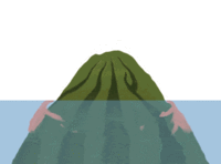
- Fringing Reef / 裾礁(きょしょう)
Coral colonizes around the volcanic island made midmost of the sea, and coral reef grows up as if surrounding it around an island. The formed coral spreads to the outside.
裾礁とは海の真ん中にできた火山島をよりどころとしてサンゴが定着し、島の周りを取り囲むようにしてサンゴ礁が成長していったものです。形成されたサンゴは外側へと広がり発達していきます。
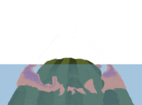
- Barrier Reef / 堡礁(ほしょう)
The sedimentation of the island advances. On the other hand, the coral reef continues growing up. A lagoon occurs between an island and leaves.
堡礁とは年月の経った裾礁の中央部の島が沈みつつも、サンゴ礁だけはどんどん大きくなったものです。潮辺りのいい外洋側は成長が早いため、サンゴ礁の縁(礁原・リーフ)は外へと広がります。こうしてサンゴ礁だけが残され、島と礁原の間に礁湖・ラグーン(サンゴ礁や島嶼に囲まれた海)が形成されます。
- Atoll / 環礁(かんしょう)
An island completely sets, and a doughnut-formed leaf is left. The central part becomes the huge lagoon. Fragments of the coral are piled up, and, on the coral reef, small islands are made.
堡礁の状態から完全に島が沈んでしまうと、ドーナツ状の礁原がだけが残されます。これが環礁です。中央部は巨大な礁湖となり、サンゴ礁上には、サンゴのかけらが積もり積もって小さな島々が見られるようになります。
- Coral reef and plate motion / サンゴ礁とプレート運動
Why will three types be in the coral reef?Plate movement of earth is related.
In the process that an island enacted by a volcano moves by plate motion in the deep sea
A coral reef changes with a Fringing Reef, Barrier Reef, an Atoll.
When a volcanic island is made in the tropical zone, a coral reef is born in the outskirts. This is a Fringing reef.
The volcanic island horizontally moves it by plate motion. The bottom of the sea is deepened, and an island starts sedimentation. This is Barrier reef.
Furthermore, the horizontal mobility of the volcanic island advances. An island completely subsides. The coral reef continues growing up. This is an atoll.
The horizontal mobility of the volcanic island continues. The coral reef finally sets in the sea, too. The coral reef is taken in the stratum as a huge rock lump of the limestone.
何故サンゴ礁には3つのタイプがあるのでしょうか? これは地球のプレート運動が関係しているといわれています。
すなわち、火山によりできた島がプレート運動により深海に移動していく過程で 裾礁、堡礁、環礁と姿を変えていくという説が有力です。
つまり、火山島が生まれた場所が熱帯であると、その周辺にサンゴ礁ができる。これが裾礁です。
そして火山島はプレート運動により水平移動し、海底は深くなっていくので島が沈降し始める。これが堡礁です。
さらに火山島の水平移動が進み、島が完全に沈降してもサンゴ礁は成長を続ける。これが環礁です。
最終的に火山島の水平移動が続くと、サンゴ礁は海溝に落ち込み、石灰岩の巨大な岩塊として地層に取り込まれます。
(これが改めて地表に出てきたのが秋吉台です)

(秋吉台科学博物館『生い立ちと地質』を加工)
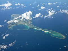
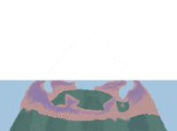
- Illustration of Kumejima / 久米島図解
A lagoon is in the southeastern part of Kumejima.
A lagoon is area of the sea surrounded by the edge made of coral reefs.
The lagoon is the rare topography in Japan. Geographical Survey Institute introduces Kumejima in a site.
久米島南東部海岸域の海域には礁湖が広がっています。
礁湖とは英語でリーフラグーンともいい、環礁・堡礁・裾礁の礁縁部分(礁原)によって取り囲まれた水域です。
これほどの規模の礁湖は日本では珍しく、国土地理院のサイトでも日本の典型地形として紹介されています。

(国土地理院の地図を加工)
Logging tasks / 宿題
Please send email the answer to following Logging tasks to cache owner.
以下の宿題の回答をキャッシュオーナーにメールしてください。
- You take the photograph GPSr or yourself on Hatenohama, and please upload it.(*Optional)
はての浜に上陸してGPSrかあなたを写真に撮ってアップロードしてください。(※オプションです。)
- Which is the type of the coral reef of Hatenohama? Fringing Reef? Barrier Reef? Atoll? Please reply it in conjunction with a reason.
はての浜はサンゴ礁の3つのタイプのうち、どれにあたりますか?裾礁、堡礁、環礁の中から理由と合わせて回答して下さい。
- The sand of the sandy beach with the coral reef such as Hate no Hama is comprised of a foraminifer and coral, a shell mainly.
Above all, particularly much one is the husks of the foraminifer. A foraminifer is an amoebic protist having a calcic husk and inhabits reef flat in particular in the coral reef.
If you arrive at Hate no Hama, you will observe sand. What are most things?Is it coral? Shell? Foraminifer?
Why is the reason if different from a general sandy beach?
You observe Hate no Hama and the outskirts and will find an answer.
はての浜のようなサンゴ礁のある砂浜の砂は主に有孔虫の殻や、サンゴが砕けたもの、貝殻片などで構成されています。
中でも特に多いのが有孔虫の殻です。有孔虫とは、石灰質の殻を持つアメーバのような原生生物でサンゴ礁においては特に礁原に生息しています。
はての浜に着いたら、砂を採って観察してみましょう。有孔虫殻、サンゴ、貝殻片のうちどれが一番多いですか?
もし、一般的な砂浜と違うならばその理由は何故でしょうか?はての浜とその周辺を観察して答えを見つけて下さい。
Access / アクセス
You must get into a boat to go to the Hatenohama.
はての浜へ行くには船が必要です。半日ほどのツアーがたくさんありますので、それに参加するのがおすすめです。