My point of view -MIA (Bonifacio)
Bonifacio is a commune at the southern tip of the island of Corsica, in the Corse-du-Sud department of France. Bonifacio is the setting of Guy de Maupassant's short story, Vendetta. The French leg of the Red Bull Cliff Diving World Series takes place in Bonifacio. Bonifacio is located directly on the Mediterranean Sea, separated from Sardinia by the Strait of Bonifacio.
The islands are part of the French portion, 794.6-square-kilometre (196,300-acre), of the international Bouches de Bonifacio ("Strait of Bonifacio") marine park, a nature reserve, signed into legal existence by France and Italy in 1993 for the protection of the strait against passage of ships bearing dangerous chemicals, and implemented in France by a ministerial decree of 1999 detailing the land to be included in the réserve naturelle de Bouches de Bonifacio for the preservation of wild birds, other fauna and flora, fish and nature in general.
The southern coast in the vicinity of Bonifacio is an outcrop of chalk-white limestone, precipitous and sculpted into unusual shapes by the ocean. Slightly further inland the limestone adjoins the granite of which the two islands, Sardinia and Corsica, are formed. The port of Bonifacio is placed on the Bay of Bonifacio, a drowned ravine of a fjord-like appearance separated from the ocean by a finger-like promontory 1,500 meters (4,900 ft) long and 200 meters (660 ft) wide. In prehistoric post-glacial times when sea levels were low and the islands were connected, the ravine was part of a valley leading to upland Corsica. The maximum draught supported by the harbor is 3.5 meters (11 ft), more than ample for ancient ships and modern small vessels.
The city of Bonifacio is split into two sections. The vieille ville (old town), or la Haute Ville (the Upper city), on the site of a citadel, is located on the promontory overlooking the Mediterranean Sea. The citadel was built in the 9th century with the foundation of the city. The Citadel has been reconstructed and renovated many times since its construction and most recently was an administrative center for the French Foreign Legion. Today it is more of a museum. Historically most of the inhabitants have resided in the Haute ville under the immediate protection of the citadel.
The city and its fortifications also extend for some distance along the cliff-tops, which are at about 70 meters (230 ft) elevation. The cliffs have been undercut by the ocean so that the buildings, which have been placed on the very lip of the precipice, appear to overhang it. The appearance from the sea is of a white city gleaming in the sun and suspended over the rough waters below.
Prehistoric period
Bonifacio has two prehistoric sites of some importance: the ancient cave shelter of Araguina-Sennola near the village of Capello on Route N96 just north of the city and a chambered tomb of Vasculacciu further north near Figari. The first is the site of the notable Lady of Bonifacio, a female burial carbon-dated to about 6570 BC, which is either late Mesolithic or Early Neolithic, and the second belongs to the Megalithic Culture and is dated to the Middle Neolithic. The alignment of the two and the extensive use of chert from Monte Arci in Sardinia shows that the Bay of Bonifacio was a route to inland Corsica from the earliest times.
Roman period
The only record of southernmost Corsica in Roman times comes from the geographer Ptolemy. He reports the coordinates of Marianum Promontory and town, which, plotted on a map, turn out to be the farthest south of Corsica. After listing the peoples of the east coast he states that the Subasani (ancient Greek Soubasanoi) were "more to the south."
The people do not appear subsequently and the town and promontory have not been identified, nor do any Roman roads point to it. The only official road, the Via Corsica, ran between the Roman castra of Mariana and Aleria on the east coast and further south to Pallas, according to the Antonine Itinerary. Ptolemy places Pallas unequivocally on the east coast north of Marianum. Although unrecorded tracks and paths to the far south are possible, it is unlikely they would have carried any significant Roman traffic.
Maritime traffic through the strait however was significant and it could hardly have neglected the fine harbor at Bonifacio. The most popular choice for Marianum Promontory therefore is Cape Pertusato, southernmost point of Corsica island, about 9 kilometers (6 mi) east of the harbor, with Bonifacio itself as Marianum town. A second possibility would be the first century AD Roman ruins adjoining Piantarella Beach near the village of Ciappili and next to the grounds of Sperone golf course, a recreational suburb to the west of Bonifacio, but those ruins appear to represent a Roman villa and the beach though eminently suitable for recreation is of little value as a port. More likely the villa belonged to a citizen of Bonifacio as Marianum.
Tuscan period
Corsica was taken from the Roman Empire in 469 AD by Genseric, king of the Vandals, and recovered by the Eastern Empire in 534. The Lombards having taken it again in 725, Charlemagne cleared them out by 774 and handed the island over to the Papacy, which had been the most powerful complainant of the island's devastation by Germanics. Starting in 806 the Moors of Spain began to contend for the island and held it for a short time but in 828 the Papacy assigned its defense to the margrave of Tuscany, a powerful state of the Holy Roman Empire nominally under the Kingdom of Italy.
The city in evidence today was founded as a fortress by and subsequently named after Boniface II of Tuscany in 828. He had led a naval expedition to suppress the Saracens of North Africa and returned to build an unassailable fortress and naval base from which the domains of Tuscany could be defended at the outermost frontier. Most of the citadel postdates the 9th century or is of uncertain date but Il Torrione, a round tower, was certainly part of the original citadel.
The cache
Caches get missing in action every day. They get muggled, eaten by wildlife or just disappear. It’s something a CO has to learn to live with. It’s “part of the game” so to speak. In most cases these caches are in action for quite some time. Is some cases caches disappear shortly after they are published. But the coordinates always remain. Only in very rare situations cache and coordinates disappear together. This is one of this situations …
Some time ago I came to (what I found) a perfect spot for a new cache. It had an awesome view of The coastline of Bonifacio and not an active cache within 161 meters. I found I nice spot for my green waterproof micro and hit it while two girls were enjoying the view of their telephone. I made some pictures of the view and of the hiding place so I had a spoiler in case that was needed. Off course I did not forget to make a screenshot of the GC app for my location for the coordinates. Or did I ? At least I did not write down the right coordinates.
I planned to check for the right coordinates soon. But by the time I found time to do so, I could not figure out where the cache was … I checked my pictures, my telephone (why did I not bring my GPS in the first place), Google and Garmin maps. All in vain. Since I badly want to find back my cache I hope you can help me. I will provide you with all the information I have. I hope you succeed to find back this cache that’s got “missing in action”. If you do find it, please send me the coordinates by mail so I will be able to find it too. This is what I got so far.
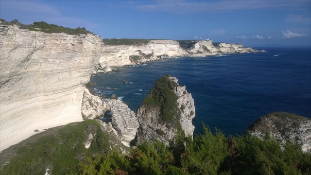
I parked my car at the parking lot close to the harbour at N41 23.308 E9 09.969 and walked for about 70 meters in direction 266 degrees. There I continued in direction south-west for about 250 meters. I then took a smaller road heading 220 degrees for about 30 meters. That road continued in direction 130 degrees for about 160 meters. From there I had a great view at the cliffs and the ocean. I took a couple of nice pictures here.
This is a picture I took that day. I’m quite sure I took it at this point. But since I took quite a few pictures that day, I’m not 100% sure. I’m quite sure there was a warning sign for dangerous cliffs here.
Then I continued my way to the east at the path closest to the sea (I think). From that point my GPS ran out of batteries …
I continued with my telephone as backup GPS. The path became steeper and smaller. At some point I took a turn right (I think) and found myself in the middle of high vegetation. I don’t remember seeing much motorized traffic here. I’m quite sure I passed a couple of spots with a nice view that I did not find suitable because they were to crowded (I believe it’s better to hide caches were you can search without being seen – too quickly). There were many small paths there and I took one that would bring me further to the coast.
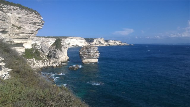
At one point I walked down a bit (as I’m not mistaken) and from there I had a very nice view of the ocean and the cliffs. It got even better when I noticed there was a sort of stone balcony were you could safely enjoy the view even more close to the side of the cliff. I made some nice pictures there. I am pretty sure this is one of them, but again not 100%, since I took quite a few pictures that day.
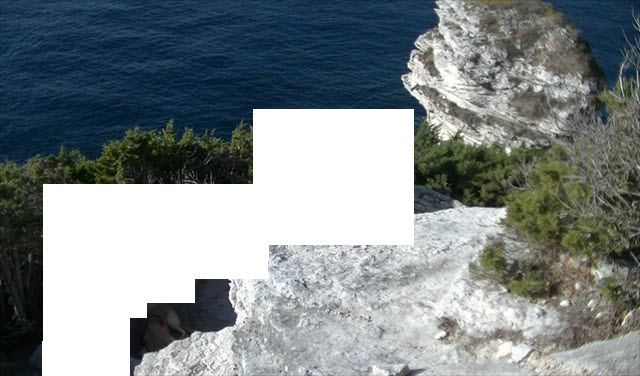
I also took a picture of the hiding place, as a spoiler.

Then I had to leave because my family was waiting (they had visited an old (?) abandoned building further up the hill. I later found out there was actually a cache there that I could have logged – if I did not choose to hide one myself).
After a few minutes I choose to back to make a picture for another spoiler. Just to be sure. By then a couple with a dog had arrived and since I could not wait longer I decided to make a picture with the couple on it. But because I did not find it appropriate to publish of a person without his consent I removed them (sorry ;-) I left the dog however).
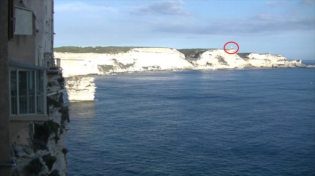
Perhaps you find it useful to know that from my point of view to the south-east I could see something that looked like a lighthouse just between two big rocks. To the north I could see a somewhat taller house in front of the harbour with the harbour behind it.
This is a picture of the lighthouse. Bear in mind that I took this pictures later that day from the village and not from the place of the cache.
This is a picture of the building in the harbour I took this picture from the place of the cache.

Well, that’s all. I hope you succeed. Since I did not … Please do not refer to the coordinates or to the solution in your log. It’s I private matter ;-) .
Put the cache back the way you found it (or better if it was visible).
Though it can be really quiet here, there are also moments there are muggles around. So use stealth when needed…
Happy caching!
Marrakesj
P.S. I had some trouble with editing some of the images after uploading. That’s is why some of them look slightly different than the original. Sorry for that.