This EarthCache is located in a portion of the Morgan Run Natural Environmental Area, with the permission of the Maryland Department of Natural Resources. Please park at the provided parking coordinates, and leave nothing behind but your footprints when you visit.
Note that you will likely need to get your feet wet in order to complete the required tasks to complete this EarthCache, as the posted coordinates and areas of interest are located in the stream bed. Please be careful on the rocks, which can be quite slick when wet, and use good judgement as to whether or not it is safe to pursue this cache when you go. If the river is up do to recent rains, you may not be able to reach ground zero safely.
Morgan Run is a small tributary of the Patapsco River. It flows generally eastward, and discharges into Liberty Lake, which was formed by Liberty Dam. Geologically, the entire watershed of Morgan Run is within the Piedmont Province of Maryland. The Maryland Geologic Survey provides an excellent description of each of the physiographic provinces of Maryland here:
http://www.mgs.md.gov/geology/
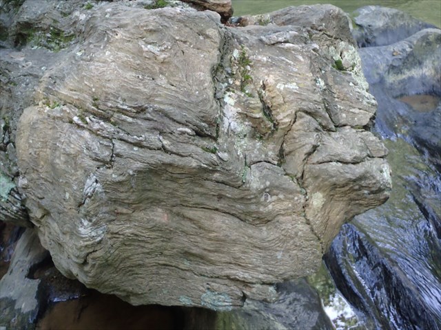
It is important to understand the underlying nature of the exposed bedrock as that contributes directly to the process by which potholes are formed. The exposed bedrock at the published coordinates of this earth cache consists of wavy schist, a metamorphosed sedimentary rock that has been folded and heated over time. There is a large, log-like boulder (a fallen column if you will) laying in the stream bed here whose end faces downstream. You can see some of the folds in the downstream end of this boulder if you look closely. White quartz crystals are also embedded in this boulder, which is of the same material as the bedrock upon which it rests. The exposed bedrock in the stream, and many of the larger boulders and outcroppings you see nearby consist of this material. It is important to note that there are other minerals present here as well, particularly an abundance of white quartz, much of which has likely eroded out of the schist over time.
As defined in the Glossary of Geology, “schist is a strongly foliated medium-grade metamorphic rock. It is characterized by an abundance of platy or elongated minerals (micas, chlorite, talc, graphite, amphiboles) in a preferred orientation. Varieties of this rock type share similarities in appearance (schistosity) but may be highly variable in composition. Individual mineral grains are discernible by the naked eye. This property sets it apart from slate. Schist is one of the most widespread rock types in the continental crust.”
So now that we know what we’re looking at, let’s talk a bit about erosion processes.
Riverine erosion is most simply defined as the wearing away and removal of sediment. There are four types of erosion processes that can occur:
1 – Hydraulic Action: occurs when sheer force of the river current dislodges rocks from the river banks and river bed and moves it downstream.
2 – Corrosion: occurs when the chemistry of the river water dissolves rocks it encounters, common when the water is acidic, and the rock is limestone.
3 – Attrition: occurs when boulders and stones are knocked together, reducing and grinding particles off of one and other. They become smaller over time as a result.
4 – Corrasion: a form of abrasion that occurs when the river picks up materials and rubs it along its bed and banks, wearing them away by abrasion. This is the major way that a river erodes both vertically and horizontally.
Our focus here will primarily be on potholes, but the broader knowledge of all riverine erosion processes will ultimately be of use to you as well.
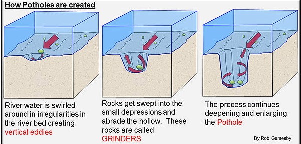
One of the fascinating and unique features of this particular site are the naturally formed potholes. There are three key elements which are required for potholes to form. One is exposed bedrock in the river bed, another is turbulence in the flow of water over that exposed bedrock, and the third is sediment carried by the water that is harder than the underlying bedrock.
Turbulence in the flow of water is caused by obstacles in the path of the flow. These cause ripples, eddies and shed vortices, and the movement of sediment within these currents abrades the adjacent exposed stone either on the river bed or along the bank. Note that this process can be episodic in nature, and more likely occurs at times of high water discharge. (see illustration below).
Potholes will form if the abrasive material (sediment, stones and cobbles) is harder than the bedrock material.
To claim a find for this earth cache, you must make a thorough examination of the area around the published coordinates, and provide answers to the questions below to the cache owner via the email link in our profile. Your answers should be sent before you log the find.
- What are the three key elements required for a pothole to form? Are they still currently present here? Would you expect potholes to continue to form at this site as time goes by?
- Please provide the dimensions (diameter and depth) of the larges pothole you found at the site.
- You are likely to find sediment, stones and other material inside one of the potholes here. Examine some of the stones you remove from a pothole, and compare them to the underlying bedrock material in which the pothole is formed. What differences do you see between the majority of stones you find inside a pothole, and the majority of the material the pothole is made of?
- Dry one of the stones you take from a pothole and scrape it against a dry portion of the exposed bedrock. What result did you expect? Did the result of your experiment match your hypothesis?
- As you examine the exposed rock over which water has flown, there are portions of it that are not as smooth, and seem not to have worn away as much. Can you explain this? What doe the less worn material look like? How does it differ?
Posting photo is optional, but if you can, please post a photo of you or a team member with your GPS at the site.
The cache owners would like to thank Dr. Kim Seelos, Planetary Geologist at the Johns Hopkins University Applied Physics Laboratory for her gracious contribution of time and knowledge in the development of this earth cache.
References:
Means, J. (2010). Roadside Geology of Maryland, Delaware and Washington, D.C. Mountain Press Publishing Company
Beard, R. (2015) Rockhounding Delaware, Maryland, and the Washington, DC Metro Area. Rowman and Littlefield.
Jackson, J. A. (1997). Glossary of Geology, 4th Edition. American Geological Institute.
Pothole illustration provided by Mr. Robert Gamesby, Head of Geography, St. Mary's Catholic School, Newcastle upon Tyne, UK
http://www.mgs.md.gov/geology/