~~A pair of binoculars may be useful for this earthcache,
especially for the extra-credit question.~~
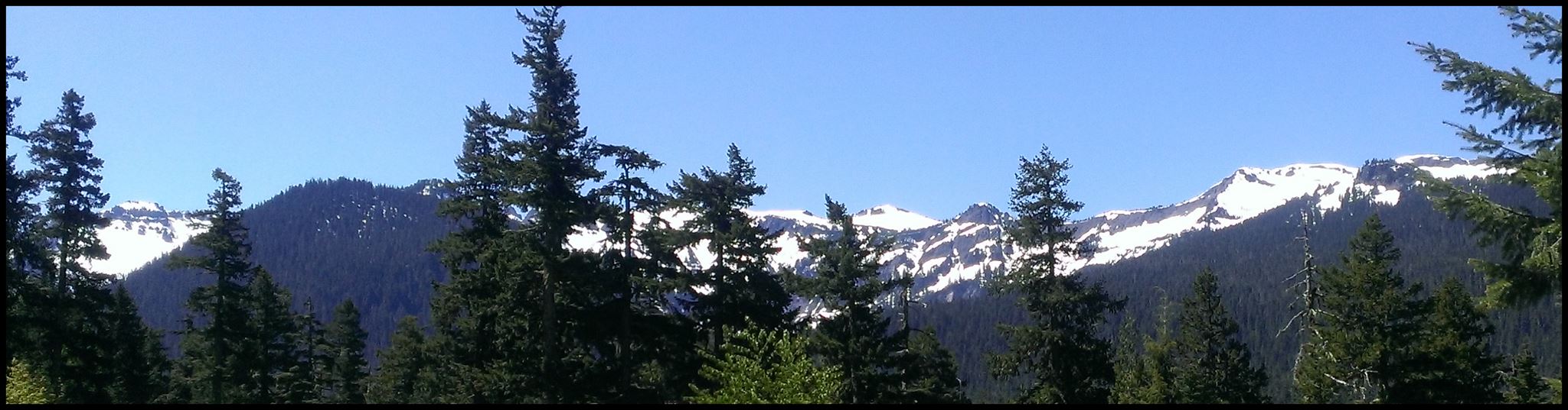
Frequently overshadowed by Mount Rainier and Mount Adams, the Goat Rocks stratovolcano, in the Goat Rocks Wilderness, is well worth a visit, providing you are able to overcome its remoteness. The Goat Rock volcano is roughly midway between Mt. Rainier and Mt. Adams. It lies in an area that has, over time, experienced intermittent volcanism and made many smaller volcanic vents.
Goat Rocks is a member of the Cascade Volcanoes and, as such, was formed by the subduction of the Juan de Fuca plate under the western side of the North American plate. This created the fault known as the Cascadia subduction zone. There are four belts of Cascade Volcanoes in Washington State. Goat Rocks is one part of the Mount Adams belt that includes Tumac Mountain, Mt. Adams itself, and the King Mountain Fissure Zone. This belt contains the second most volcanoes of the four. They are made primarily of calc-alkalic to tholeiitic to basaltic andesite lava. With Mount Adams, Mount Rainier, and Mount St. Helens, the Goat Rocks volcano is part of a triangle of volcanoes, an arrangement not found elsewhere in the Cascades. (Interestingly, all of these volcanoes are stratovolcanoes and are considered active.) The causes of this are not well understood. It could be related to a mid-crust zone with very high electrical conductivity (the Southern Washington Cascades Conductor), or to the idea that the region's volcanism has caused a partial melting of the crust.
The Goat Rocks stratovolcano has a complicated eruption history. It was first active about 3.2 million years ago. It underwent eruptions that produced silicic lava with felsic rocks like rhyolite. One of these eruptions produced 650 meters of tuff that is still visible on the east side of the existing mountain. Three million years ago, its eruptions shifted to mafic volcanism and erupted olivine and basalt. Continuing eruptions produced increasingly andesitic lava flows, which formed the volcano's major edifice, roughly 0.5 to 2.5 million years ago. This volcano's eruptions were very voluminous and reached far from its source, possibly because several satellite vents contributed to the eruptions. At that time, the Goat Rocks Volcano could have resembled present-day Mount Rainier, both in size and shape. About 1 million years ago, Goat Rocks erupted with an andesitic lava flow that stretched 80 km down the Naches and Tieton Rivers. This has been recognized as the longest andesite flow on Earth.
Since this stratovolcano became extinct, possibly as recently as 500,000 years ago, Goat Rocks has been subject to extensive erosion, both from glaciation and hydrothermal alteration. Hydrothermal alteration has impacted the volcano's interior, while glaciation has stripped away layers of volcanic ash deposits and lava flows. This has uncovered rocky lava spines where magma cooled and hardened in the volcano's conduits. Nearly all that remains of the volcanic debris has been partially covered by a younger layer of rock.
Glaciers erode terrain through two main processes: abrasion and plucking. Plucking is started when subglacial water penetrates the rock below it through fractures or breaks. This water subsequently freezes and expands. This expansion makes the ice act as a lever, which loosens the rock and lifts it. Abrasion happens when the ice, with its load of rock, slides over bedrock below it, functioning similarly to sandpaper. This action produces what is known as rock flour, tiny pieces of rock between 0.002 and 0.00625 mm in size. Valleys created by glaciers are usually characterized by a U shape, while a river valley has a more typical V shape. Along with numerous smaller snowfields, glaciers are still present on the north and northeast slopes of the Goat Rocks peaks: Conrad Glacier, McCall Glacier, Meade Glacier, and Packwood Glacier.
About the Goat Rocks Wilderness: Named for the animals that live there, Goat Rocks Wilderness is approximately 108,000 acres. A smaller part of this area was initially protected by the USDA in 1931. Its size was increased in 1935 and again in 1941. Goat Rocks Wilderness was officially created by Congress in 1964 and its management was turned over to the Forest Service. The wilderness area is frequented by hikers, but is considered remote. A free permit is required for entry.
Glossary of Terms:
- andesitic: a dark-colored volcanic rock composed essentially of plagioclase feldspar and one or more mafic minerals, as hornblende or biotite
- basalt: the dark, dense igneous rock of a lava flow or minor intrusion, composed essentially of labradorite and pyroxene and often displaying a columnar structure
- calc-alkalic: the name given to a suite of rocks comprising the volcanic association basalt-andesite-dacite-rhyolite; these types of rocks are typically developed on the continental side of plate subduction zones
- felsic: (of rocks) consisting chiefly of feldspars, feldspathoids, quartz, and other light-colored minerals
- hydrothermal alteration:hydrothermal alteration occurs when the minerals in the old rock are changed because a change in the conditions; these changes could be in temperature, pressure, chemical conditions, or any number of these; hydrothermal alteration is the change of a mineral composition when it has come in contact with hot water fluids called, hydrothermal fluids
- mafic: of or relating to rocks rich in dark, ferromagnesian minerals
- olivine: any of a group of magnesium iron silicates, occurring in olive-green to gray-green masses as an important constituent of basic igneous rocks
- rhyolite: a fine-grained igneous rock rich in silica; the volcanic equivalent of granite
- silicic: of or relating to silica or acids derived from it
- stratovolcano: a large, steep volcano built up of alternating layers of lava and ash or cinders
- subduction: the process by which collision of the earth's crustal plates results in one plate's being drawn down or overridden by another, localized along the juncture (subduction zone) of two plates
- tholeiitic: any of a series of igneous rocks similar in composition to basalt but having more silica and iron, and less aluminum
- tuff: a fragmental rock consisting of the smaller kinds of volcanic detritus, as ash or cinder, usually more or less stratified
- volcanic vents: openings in the earth's crust that allow for volcanic materials to spew out
More about this earthcache:
- There is more than enough parking here. My thought is, if your rig doesn't fit here, then it may not be legal! LOL!
- There is no need to leave the gravel parking area or viewpoint to complete the questions for this earthcache. The questions to complete this earthcache are below. They are not meant to be difficult.
- This site is typically closed by snow during the winter months from December through April.
- If you are interested in actually hiking into the wilderness to see some of the geology mentioned above, the local Cowlitz Valley Ranger District office in Randle is a good source for information, maps, road and trail conditions, etc. Another great source, although a bit dated, is Washington's South Cascades' Volcanic Landscapes, by Marge & Ted Mueller, and published by The Mountaineers.
The questions: Please email me the answers to the following questions on the same day that you log your successful find of this earthcache. Do not include the answers in your online log. Online logs without the answers emailed to me on the same day risk deletion. If you are concerned that there could be an issue, save your answers in the "Personal Cache Note" section near the top of the cache page. (That might be good general practice, anyway.)
- Why is this stratovolcano shaped differently than its nearby cousins Mt. Rainier and Mt. Adams?
- Although you might not have the best view of them, what shape might you expect the valleys in the Goat Rocks area to have? Why?
- Extra Credit Question: Were you able to seek any glaciers or goats on Goat Rocks?
Resources consulted for this earthcache included:
- https://en.wikipedia.org/wiki/List_of_stratovolcanoes
- https://en.wikipedia.org/wiki/Goat_Rocks
- Washington's South Cascades' Volcanic Landscapes by Marge & Ted Mueller
- http://www.fs.usda.gov/recarea/giffordpinchot/recarea/?recid=79414
- http://america.pink/goat-rocks_1755442.html
- www.thefreedictionary.com, www.encylopedia.com, & www.dictionary.com
2016 was the 100th anniversary of the National Park Service, and to celebrate, Visit Rainier and WSGA hosted the Visit Rainier Centennial GeoTour - 100 caches placed in and around Mount Rainier National Park. The geocaches highlighted the rich history, scenic wonders, quaint communities, and hidden gems of the Rainier region. Participants received geocoin and pathtag prizes for finding all the caches.

